Gharb-chrarda-beni Hssen - Kenitra
Airport details
| Country | Morocco |
| State | Kénitra Province |
| Region | |
| Airspace | Casablanca Ctr |
| Municipality | Kenitra |
| Elevation | 16ft (5m) |
| Timezone | GMT +0 |
| Coordinates | 34.29954, -6.59445 |
| Magnetic var | |
| Type | land |
| Available since | X-Plane v10.40 |
| ICAO code | GMMY |
| IATA code | NNA |
| FAA code | n/a |
Communication
Nearby Points of Interest:
La Mamora
-Bouknadel Gardens
-Borj El kébir
-Zawiya en-Noussak
-Medina of Salé
-Madrasa Bou Inaniya (Salé)
-Marinid Madrasa of Salé
-Enclosure of the Medina of Salé
-Bab Bouhaja
-Bab el-Mrissa
-Bab Dar Assinaa
-Borj Sidi Makhlouf
-Medina of Rabat
-Borj Lalla Qadiya
-Great Mosque of Rabat
-Borj Sirat
-Agency for the development of the Bouregreg valley
-Rabat-City train station
-As-Sunna Mosque (Rabat)
-Moulay Youssef College
-M'hammed Guessous School
-Dar al-Makhzen
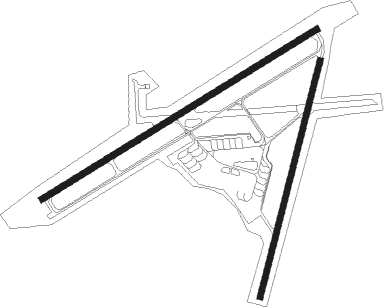
Runway info
Runway 07 / 25  | ||
| length | 2434m (7986ft) | |
| bearing | 67° / 247° | |
| width | 46m (150ft) | |
| surface | concrete | |
| Runway 03 / 21 | ||
| length | 1838m (6030ft) | |
| bearing | 22° / 202° | |
| width | 46m (150ft) | |
| surface | asphalt | |
Nearby beacons
| code | identifier | dist | bearing | frequency |
|---|---|---|---|---|
| CNL | KENITRA NDB | 1.4 | 245° | 380 |
| SBI | RABAT NDB | 8.1 | 210° | 332 |
| RBT | RABAT VOR/DME | 16.7 | 211° | 116.50 |
| SMN | SIDI SLIMANE VOR/DME | 27.1 | 97° | 115.50 |
| CAE | BENSLIMANE NDB | 48.5 | 217° | 275 |
| BNS | BENSLIMANE VOR/DME | 49.9 | 223° | 117.45 |
Disclaimer
The information on this website is not for real aviation. Use this data with the X-Plane flight simulator only! Data taken with kind consent from X-Plane 12 source code and data files. Content is subject to change without notice.