Zouérate - Zouerate Tazadit
Airport details
| Country | Mauritania |
| State | Tiris Zemmour |
| Region | GQ |
| Airspace | Dakar Ctr |
| Municipality | Zouérat |
| Elevation | 1127ft (344m) |
| Timezone | GMT +0 |
| Coordinates | 22.75805, -12.46861 |
| Magnetic var | |
| Type | land |
| Available since | X-Plane v10.40 |
| ICAO code | GQPZ |
| IATA code | OUZ |
| FAA code | n/a |
Communication
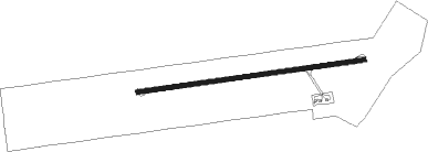
Runway info
| Runway 09 / 27 | ||
| length | 2493m (8179ft) | |
| bearing | 87° / 267° | |
| width | 45m (149ft) | |
| surface | asphalt | |
Nearby beacons
| code | identifier | dist | bearing | frequency |
|---|---|---|---|---|
| ZRT | ZOUERATE VOR | 0.3 | 86° | 112.70 |
Disclaimer
The information on this website is not for real aviation. Use this data with the X-Plane flight simulator only! Data taken with kind consent from X-Plane 12 source code and data files. Content is subject to change without notice.