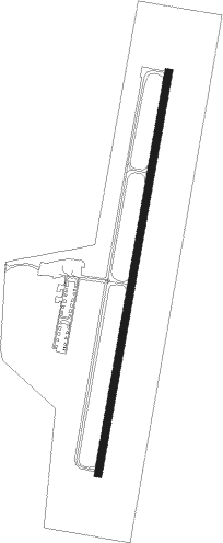
Fredericktown - Fredericktown Regnl
Airport details
| Country | United States of America |
| State | Missouri |
| Region | K3 |
| Airspace | Kansas City Ctr |
| Municipality | Madison County |
| Elevation | 878ft (268m) |
| Timezone | GMT -6 |
| Coordinates | 37.60564, -90.28748 |
| Magnetic var | |
| Type | land |
| Available since | X-Plane v10.40 |
| ICAO code | H88 |
| IATA code | n/a |
| FAA code | n/a |
Communication
| Fredericktown Regnl CTAF/UNICOM | 122.800 |
Nearby Points of Interest:
Fredericktown Missouri Pacific Railroad Depot
-Fredericktown Courthouse Square Historic District
-Madison County Courthouse
-Courthouse Square Historic District
-East Columbia Historic District
-St. Francois County Jail and Sheriff's Residence
-James Robinson McCormick House
-Presbyterian Orphanage of Missouri
-St. Paul's Episcopal Church
-Iron County Courthouse
-Ironton Lodge Hall
-Fort Davidson
-Immanuel Evangelical Lutheran Church (Pilot Knob, Missouri)
-St. Mary's of the Barrens Catholic Church
-Shelby-Nicholson-Schindler House
-Doerr–Brown House
-Perry County Courthouse
-Bonne Terre Depot
-Amoureux House
-Jacques Guibourd Historic House
-Madison County Sheriff's House and Jail
-Harrison Queen House
-Old Appleton Bridge
-Pierre Menard House
-Frederick Weistar House
Nearby beacons
| code | identifier | dist | bearing | frequency |
|---|---|---|---|---|
| FAM | FARMINGTON VORTAC | 4.8 | 38° | 115.70 |
| CG | DUTCH (CAPE GIRARDEAU) NDB | 35 | 121° | 248 |
| CGI | GIRARDEAU DME | 40.9 | 118° | 112.90 |
| CP | ACORE (CAHOKIA/ST LOUIS) NDB | 55.9 | 14° | 350 |
| JD | GOOEY (BELLEVILLE) NDB | 58.4 | 32° | 385 |
| SKE | SCOTT (BELLEVILLE) TACAN | 60 | 25° | 112.20 |
Instrument approach procedures
| runway | airway (heading) | route (dist, bearing) |
|---|---|---|
| RW01 | GUCFY (18°) | GUCFY 3300ft |
| RNAV | GUCFY 3300ft YUXTI (5mi, 18°) 2600ft ZIKTO (3mi, 18°) 1580ft H88 (2mi, 18°) 915ft (5419mi, 113°) 1161ft GIFYO (5416mi, 293°) 3300ft GIFYO (turn) | |
| RW19 | GIFYO (198°) | GIFYO 3300ft |
| RNAV | GIFYO 3300ft YONVY (5mi, 198°) 2600ft WEPIG (2mi, 198°) 1800ft H88 (3mi, 198°) 917ft (5419mi, 113°) 1161ft GUCFY (5421mi, 293°) 3300ft GUCFY (turn) |
Disclaimer
The information on this website is not for real aviation. Use this data with the X-Plane flight simulator only! Data taken with kind consent from X-Plane 12 source code and data files. Content is subject to change without notice.
