Bujumbura - Bujumbura Intl
Airport details
| Country | Burundi |
| State | Bujumbura Mairie |
| Region | HB |
| Municipality | Bujumbura |
| Elevation | 2582ft (787m) |
| Timezone | GMT +2 |
| Coordinates | -3.32067, 29.31760 |
| Magnetic var | |
| Type | land |
| Available since | X-Plane v10.40 |
| ICAO code | HBBA |
| IATA code | BJM |
| FAA code | n/a |
Communication
| Bujumbura Intl Ground Control | 121.900 |
| Bujumbura Intl Tower | 118.100 |
| Bujumbura Intl Approach | 119.700 |
Approach frequencies
| ILS-cat-I | RW17 | 110.1 | 18.00mi |
| 3.2° GS | RW17 | 110.1 | 18.00mi |
Nearby Points of Interest:
Mugamba
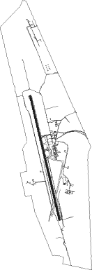
Runway info
| Runway 17 / 35 | ||
| length | 3626m (11896ft) | |
| bearing | 171° / 351° | |
| width | 45m (148ft) | |
| surface | asphalt | |
| blast zone | 18m (59ft) / 18m (59ft) | |
Nearby beacons
| code | identifier | dist | bearing | frequency |
|---|---|---|---|---|
| BJA | BUJUMBURA VOR/DME | 1.5 | 170° | 112.30 |
| BS | BUJUMBURA NDB | 1.6 | 170° | 285 |
| BN | BUJUMBURA NDB | 4.3 | 351° | 255 |
| KW | BUJUMBURA NDB | 11.4 | 351° | 385 |
| RG | RWEGURA NDB | 27.1 | 26° | 305 |
| GI | GITEGA NDB | 36.2 | 99° | 360 |
| BU | BUTARE NDB | 49.9 | 30° | 340 |
| YI | RUYIGI NDB | 56.5 | 99° | 275 |
| DO | KIRUNDO NDB | 66.2 | 45° | 295 |
Disclaimer
The information on this website is not for real aviation. Use this data with the X-Plane flight simulator only! Data taken with kind consent from X-Plane 12 source code and data files. Content is subject to change without notice.