Lamu - Lamu Manda
Airport details
| Country | Kenya |
| State | Lamu |
| Region | HK |
| Airspace | Nairobi Ctr |
| Elevation | 20ft (6m) |
| Timezone | GMT +3 |
| Coordinates | -2.25234, 40.91311 |
| Magnetic var | |
| Type | land |
| Available since | X-Plane v10.40 |
| ICAO code | HKLU |
| IATA code | LAU |
| FAA code | n/a |
Communication
Nearby Points of Interest:
Lamu Fort
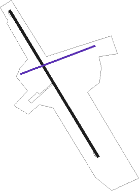
Runway info
Runway 15 / 33  | ||
| length | 2012m (6601ft) | |
| bearing | 153° / 333° | |
| width | 30m (98ft) | |
| surface | asphalt | |
| Runway 08 / 26 | ||
| length | 932m (3058ft) | |
| bearing | 74° / 254° | |
| width | 14m (46ft) | |
| surface | dirt | |
Instrument approach procedures
| runway | airway (heading) | route (dist, bearing) |
|---|---|---|
| RW15 | AXOLU (126°) | AXOLU OKSEG (6mi, 71°) 1700ft |
| RW15 | USUKU (153°) | USUKU OKSEG (7mi, 153°) 1700ft |
| RNAV | OKSEG 1700ft OKDIL (5mi, 153°) 1700ft HKLU (6mi, 153°) 67ft (2460mi, 273°) 1000ft AXOLU (2449mi, 93°) AXOLU (turn) | |
| RW33 | APGOG (3°) | APGOG OKNIS (6mi, 65°) 1700ft |
| RW33 | UTOXI (333°) | UTOXI OKNIS (6mi, 333°) 1700ft |
| RNAV | OKNIS 1700ft XABOR (5mi, 333°) 1700ft HKLU (6mi, 333°) 68ft (2460mi, 273°) 1000ft APGOG (2460mi, 93°) APGOG (turn) |
Disclaimer
The information on this website is not for real aviation. Use this data with the X-Plane flight simulator only! Data taken with kind consent from X-Plane 12 source code and data files. Content is subject to change without notice.