Nairobi - Nairobi Eastleigh
Airport details
| Country | Kenya |
| State | Nairobi Province |
| Region | HK |
| Airspace | Nairobi Ctr |
| Municipality | Nairobi |
| Elevation | 5334ft (1626m) |
| Timezone | GMT +3 |
| Coordinates | -1.27460, 36.86174 |
| Magnetic var | |
| Type | land |
| Available since | X-Plane v10.40 |
| ICAO code | HKRE |
| IATA code | n/a |
| FAA code | n/a |
Communication
| Nairobi Eastleigh EASTLEIGH Tower | 124.300 |
Nearby Points of Interest:
Olorgesailie
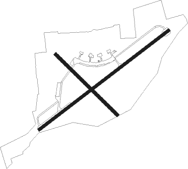
Runway info
Runway 06 / 24  | ||
| length | 2440m (8005ft) | |
| bearing | 57° / 237° | |
| width | 46m (151ft) | |
| surface | asphalt | |
| Runway 13 / 31 | ||
| length | 1289m (4229ft) | |
| bearing | 139° / 319° | |
| width | 50m (164ft) | |
| surface | dirt | |
Nearby beacons
| code | identifier | dist | bearing | frequency |
|---|---|---|---|---|
| NO | NAIROBI NDB | 5.4 | 179° | 278 |
| NV | NAVEX VOR/DME | 5.7 | 105° | 113.10 |
| GV | NGONG VOR | 15.3 | 241° | 115.90 |
| TH | ATHI RIVER (NAIROBI) NDB | 16.6 | 145° | 329 |
| TV | STONY VOR | 16.7 | 145° | 115.50 |
| NAK | LANET VOR/DME | 72 | 324° | 115.10 |
Disclaimer
The information on this website is not for real aviation. Use this data with the X-Plane flight simulator only! Data taken with kind consent from X-Plane 12 source code and data files. Content is subject to change without notice.