Gisenyi
Airport details
| Country | Rwanda |
| State | Western Province |
| Region | HR |
| Municipality | Gisenyi |
| Elevation | 5082ft (1549m) |
| Timezone | GMT +2 |
| Coordinates | -1.67667, 29.25917 |
| Magnetic var | |
| Type | land |
| Available since | X-Plane v10.40 |
| ICAO code | HRYG |
| IATA code | GYI |
| FAA code | n/a |
Communication
| Gisenyi Tower | 121.800 |
| Gisenyi GOMA Approach | 118.700 |
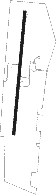
Runway info
| Runway 01 / 19 | ||
| length | 1020m (3346ft) | |
| bearing | 10° / 190° | |
| width | 23m (75ft) | |
| surface | asphalt | |
Nearby beacons
| code | identifier | dist | bearing | frequency |
|---|---|---|---|---|
| GOM | GOMA VOR/DME | 1.1 | 264° | 116.50 |
| GS | GOMA NDB | 1.7 | 217° | 397 |
| KS | KISORO NDB | 36.2 | 49° | 258 |
| BKV | BUKAVU NDB | 46.8 | 215° | 514 |
| KNM | KIGALI VOR/DME | 56.1 | 108° | 114.90 |
| BU | BUTARE NDB | 62.3 | 153° | 340 |
| DO | KIRUNDO NDB | 72.7 | 136° | 295 |
Disclaimer
The information on this website is not for real aviation. Use this data with the X-Plane flight simulator only! Data taken with kind consent from X-Plane 12 source code and data files. Content is subject to change without notice.