Wadi Halfa
Airport details
| Country | Sudan |
| State | Northern State |
| Region | HS |
| Airspace | Khartoum Ctr |
| Elevation | 960ft (293m) |
| Timezone | GMT +3 |
| Coordinates | 21.80572, 31.52766 |
| Magnetic var | |
| Type | land |
| Available since | X-Plane v10.40 |
| ICAO code | HSSW |
| IATA code | WHF |
| FAA code | n/a |
Communication
Nearby Points of Interest:
Nubian Monuments from Abu Simbel to Philae
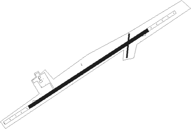
Runway info
Runway 06 / 24  | ||
| length | 2057m (6749ft) | |
| bearing | 63° / 243° | |
| width | 46m (151ft) | |
| surface | dirt | |
| displ threshold | 33m (108ft) / 21m (69ft) | |
| blast zone | 255m (837ft) / 255m (837ft) | |
| Runway 01 / 19 | ||
| length | 345m (1132ft) | |
| bearing | 11° / 191° | |
| width | 17m (56ft) | |
| surface | dirt | |
| displ threshold | 12m (39ft) / 13m (43ft) | |
Nearby beacons
| code | identifier | dist | bearing | frequency |
|---|---|---|---|---|
| SML | ABU SIMBEL VOR/DME | 33.4 | 10° | 113.50 |
Disclaimer
The information on this website is not for real aviation. Use this data with the X-Plane flight simulator only! Data taken with kind consent from X-Plane 12 source code and data files. Content is subject to change without notice.