Tanga
Airport details
| Country | Tanzania |
| State | Tanga Region |
| Region | HT |
| Airspace | Dar-es-salaam Ctr |
| Municipality | Tanga |
| Elevation | 127ft (39m) |
| Timezone | GMT +3 |
| Coordinates | -5.09211, 39.07159 |
| Magnetic var | |
| Type | land |
| Available since | X-Plane v10.40 |
| ICAO code | HTTG |
| IATA code | TGT |
| FAA code | n/a |
Communication
| Tanga INFO | 122.100 |
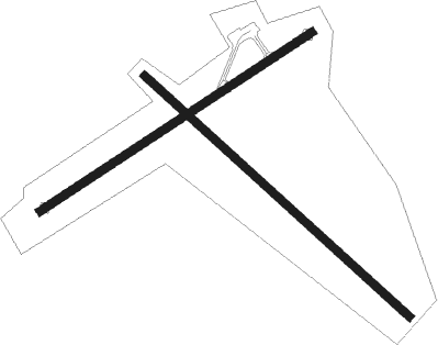
Runway info
Runway 06 / 24  | ||
| length | 1260m (4134ft) | |
| bearing | 61° / 241° | |
| width | 31m (102ft) | |
| surface | asphalt | |
| Runway 14 / 32 | ||
| length | 1386m (4547ft) | |
| bearing | 137° / 317° | |
| width | 30m (98ft) | |
| surface | grass | |
Nearby beacons
| code | identifier | dist | bearing | frequency |
|---|---|---|---|---|
| TG | TANGA NDB | 0.2 | 24° | 407 |
| PA | PEMBA NDB | 45.5 | 103° | 345 |
Disclaimer
The information on this website is not for real aviation. Use this data with the X-Plane flight simulator only! Data taken with kind consent from X-Plane 12 source code and data files. Content is subject to change without notice.