Hazard - Wendell H. Ford
Airport details
| Country | United States of America |
| State | Kentucky |
| Region | K5 |
| Airspace | Indianapolis Ctr |
| Municipality | Perry County |
| Elevation | 1255ft (383m) |
| Timezone | GMT -5 |
| Coordinates | 37.38736, -83.26161 |
| Magnetic var | |
| Type | land |
| Available since | X-Plane v10.40 |
| ICAO code | K20 |
| IATA code | n/a |
| FAA code | CPF |
Communication
| Wendell H. Ford AWOS 3 | 119.025 |
| Wendell H. Ford CTAF/UNICOM | 122.700 |
Nearby Points of Interest:
Buckhorn Presbyterian Church and the Greer Gymnasium
-Roderick McIntosh Farm
-M.E. Church, South
-Breathitt County Jail
-Jackson Commercial District
-Wooton Presbyterian Center
-Bolen Building
-Hindman Ben Franklin
-Hindman Historic District
-Salyersville National Bank
-Beattyville Grade School
-St. Thomas Episcopal Church
-John Shell Cabin
-William L. Hurst Law Office
-Whitesburg Historic District
-Cumberland Central Business District
-Methodist Episcopal Church, South (Prestonsburg, Kentucky)
-Samuel May House
-Benham Historic District
-Lynch Historic District
-Red River Gorge
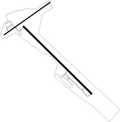
Runway info
Runway 14 / 32  | ||
| length | 1676m (5499ft) | |
| bearing | 132° / 312° | |
| width | 30m (100ft) | |
| surface | asphalt | |
| Runway 6 / 24 | ||
| length | 986m (3235ft) | |
| bearing | 65° / 245° | |
| width | 18m (60ft) | |
| surface | asphalt | |
| displ threshold | 64m (210ft) / 81m (266ft) | |
Nearby beacons
| code | identifier | dist | bearing | frequency |
|---|---|---|---|---|
| AZQ | DME | 0.2 | 340° | 111.20 |
| LOZ | LONDON VOR/DME | 45.8 | 247° | 116.55 |
| ECB | DME | 49.2 | 25° | 110.40 |
| IOB | MOUNT STERLING NDB | 52.9 | 313° | 210 |
| RVN | ROGERSVILLE NDB | 58.7 | 158° | 329 |
| TR | MOCCA(BRISTOL-JOHNSON-KINGSPOR NDB | 67.4 | 131° | 299 |
| BO | BOOIE (BRISTOL) NDB | 69.8 | 142° | 221 |
Disclaimer
The information on this website is not for real aviation. Use this data with the X-Plane flight simulator only! Data taken with kind consent from X-Plane 12 source code and data files. Content is subject to change without notice.