Airports for X-Plane offers a convenient way to explore airports and their related communication information for the X-Plane flight simulator. It only uses data from the X-Plane flight simulator itself, and is therefore more reliable than the data that comes from real aviation websites. You can search for airports by using the ICAO code, or browse for airports per country and state. The information displayed is categorized by airport details, runway information, airport communication, approach frequencies (ILS and Glidepath details), details of nearby beacons, SIDs, STARs and approach procedures.

airfield airstrip warfare takeoff immigration airport authority commuter seaplanes arriving airplane regional flown automated airport weather station concrete drome airliner air terminal non-towered airport international passengers

Osborne - Osborne Muni

Airport details

CountryUnited States of America
StateKansas
RegionK3
AirspaceKansas City Ctr
MunicipalityOsborne County
Elevation1563ft (476m)
TimezoneGMT -6
Coordinates39.43330, -98.68003
Magnetic var
Typeland
Available sinceX-Plane v10.40
ICAO codeK75
IATA coden/a
FAA coden/a

Communication

Osborne Muni CTAF122.900
Nearby Points of Interest:
Old Cawker City Library
-
Meades Ranch Triangulation Station
-
E. W. Norris Service Station
-
Natoma Presbyterian Church
-
Paradise Water Tower
-
Pottawatomie County Fair Pavilion
-
Kirwin City Hall
-
Mitchell County Courthouse
-
St. John the Baptist Catholic Church
-
Rooks County Courthouse
-
Danske Evangelist Lutheran Kirke
-
Home on the Range Cabin
-
Jewell County Courthouse

Runway info

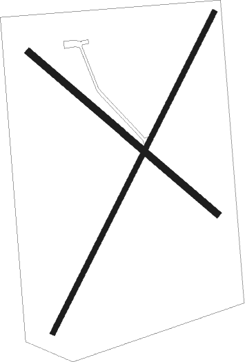
Runway 2 / 20  
 length1284m (4213ft)
 bearing38° / 218°
 width18m (60ft)
 surfaceasphalt
 displ threshold30m (98ft) / 49m (161ft)
Runway 12 / 30  
 length887m (2910ft)
 bearing128° / 308°
 width24m (80ft)
 surfacegrass

Airport layout


Parking locations

Nearby beacons

codeidentifierdistbearingfrequency
TKOMANKATO VORTAC29.648°109.80
HYSHAYS VORTAC44.8226°110.40
HYNETTE (HAYS) NDB47.9221°374

Disclaimer

The information on this website is not for real aviation. Use this data with the X-Plane flight simulator only! Data taken with kind consent from X-Plane 12 source code and data files. Content is subject to change without notice.