Allentown - Lehigh Valley Intl
Airport details
| Country | United States of America |
| State | Pennsylvania |
| Region | K6 |
| Airspace | New York Ctr |
| Municipality | Hanover Township |
| Elevation | 394ft (120m) |
| Timezone | GMT -5 |
| Coordinates | 40.65236, -75.44041 |
| Magnetic var | |
| Type | land |
| Available since | X-Plane v10.40 |
| ICAO code | KABE |
| IATA code | ABE |
| FAA code | ABE |
Communication
| Lehigh Valley Intl ATIS | 126.975 |
| Lehigh Valley Intl UNICOM | 122.950 |
| Lehigh Valley Intl Flight Service | 122.200 |
| Lehigh Valley Intl Clearance DEL | 124.050 |
| Lehigh Valley Intl Ground Control | 121.900 |
| Lehigh Valley Intl Tower | 120.500 |
| Lehigh Valley Intl Approach/Departure | 119.650 |
| Lehigh Valley Intl Approach/Departure | 124.450 |
Approach frequencies
| ILS-cat-I | RW06 | 110.7 | 18.00mi |
| ILS-cat-I | RW13 | 111.9 | 18.00mi |
| ILS-cat-I | RW24 | 108.55 | 18.00mi |
| 3° GS | RW06 | 110.7 | 18.00mi |
| 3° GS | RW13 | 111.9 | 18.00mi |
| 3° GS | RW24 | 108.55 | 18.00mi |
Nearby Points of Interest:
Biery's Port Historic District
-Coopersburg Historic District
-Catasauqua Residential Historic District
-Dent Hardware Company Factory Complex
-Neuweiler Brewery
-Helfrich's Springs Grist Mill
-Coplay Cement Company Kilns
-Bethlehem Silk Mill
-Bethlehem Armory
-Old Lehigh County Courthouse
-Allentown National Bank
-Gristmiller's House
-Zollinger-Harned Company Building
-Bethlehem Waterworks
-Dime Savings and Trust Company
-Central Bethlehem Historic District
-Historic Moravian Bethlehem Historic District
-Lehigh Valley Railroad Headquarters Building
-Fountain Hill Historic District
-Gauff-Roth House
-Bethlehem Steel Lehigh Plant Mill No. 2 Annex
-Lehigh Valley Silk Mills
-Albertus L. Meyers Bridge
-South Bethlehem Downtown Historic District
-Pembroke Village
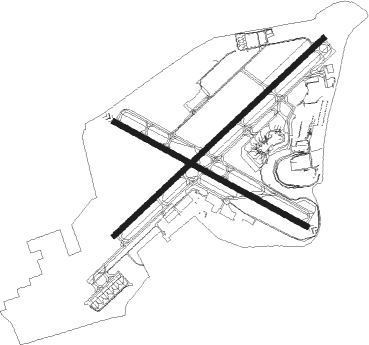
Runway info
Runway 6 / 24  | ||
| length | 2318m (7605ft) | |
| bearing | 59° / 239° | |
| width | 46m (150ft) | |
| surface | asphalt | |
| displ threshold | 0m (0ft) / 152m (499ft) | |
| blast zone | 7m (23ft) / 60m (197ft) | |
| Runway 13 / 31 | ||
| length | 1765m (5791ft) | |
| bearing | 116° / 296° | |
| width | 46m (150ft) | |
| surface | asphalt | |
| blast zone | 11m (36ft) / 9m (30ft) | |
Nearby beacons
| code | identifier | dist | bearing | frequency |
|---|---|---|---|---|
| FJC | ALLENTOWN VORTAC | 4.5 | 349° | 117.50 |
| ETX | EAST TEXAS VOR/DME | 11.9 | 254° | 110.20 |
| PTW | POTTSTOWN VORTAC | 26.4 | 196° | 116.50 |
| BWZ | BROADWAY (SCHOOLEY'S MT) VOR/DME | 29.4 | 77° | 114.20 |
| SBJ | SOLBERG VOR/DME | 32.1 | 96° | 112.90 |
| ING | AMBLER NDB | 32.4 | 164° | 275 |
| STW | STILLWATER VOR/DME | 33.1 | 59° | 109.60 |
| ARD | YARDLEY VOR/DME | 34.1 | 127° | 108.20 |
| LVZ | WILKES-BARRE VORTAC | 38.9 | 338° | 111.60 |
| MXE | MODENA VORTAC | 45.3 | 197° | 113.20 |
| SAX | SPARTA VORTAC | 47.9 | 65° | 115.70 |
| LRP | LANCASTER VOR/DME | 50.3 | 238° | 117.30 |
| RBV | ROBBINSVILLE VORTAC | 50.9 | 115° | 113.80 |
| GXU | MC GUIRE (WRIGHTSTOWN) VORTAC | 54.6 | 127° | 110.60 |
| DQO | DUPONT (WILMINGTON) VORTAC | 59 | 190° | 114 |
| HUO | HUGUENOT VOR/DME | 59.5 | 48° | 116.10 |
Instrument approach procedures
| runway | airway (heading) | route (dist, bearing) |
|---|---|---|
| RW06 | ARD (307°) | ARD HADAD (31mi, 283°) 4000ft JISTO (8mi, 313°) 3000ft |
| RW06 | BEERS (175°) | BEERS SAYOV (21mi, 233°) 4000ft JISTO (9mi, 133°) 3000ft |
| RW06 | DUMMR (75°) | DUMMR SAYOV (17mi, 63°) 4000ft JISTO (9mi, 133°) 3000ft |
| RNAV | JISTO 3000ft SHAGY (7mi, 58°) 2400ft GEBLE (3mi, 59°) 1400ft KABE (4mi, 59°) 450ft (4745mi, 118°) 594ft FONUP (4737mi, 298°) 3000ft FONUP (turn) | |
| RW13 | BEERS (175°) | BEERS TIKLE (8mi, 261°) 4000ft LOCID (6mi, 191°) 3000ft |
| RW13 | DUMMR (75°) | DUMMR JAREV (21mi, 56°) 4000ft LOCID (6mi, 64°) 3000ft |
| RW13 | ROCOY (176°) | ROCOY TIKLE (14mi, 222°) 4000ft LOCID (6mi, 191°) 3000ft |
| RNAV | LOCID 3000ft MOOVY (5mi, 116°) 2400ft IZKIP (4mi, 116°) 1260ft KABE (3mi, 115°) 439ft (4745mi, 118°) 586ft KOCEC (4741mi, 298°) LIZZI (10mi, 76°) 3000ft LIZZI (turn) | |
| RW24 | DUMMR (75°) | DUMMR BEERS (39mi, 58°) 4000ft RIRAE (8mi, 81°) 4000ft CICAT (4mi, 156°) 3700ft FONUP (4mi, 156°) 3000ft |
| RW24 | SBJ (276°) | SBJ PIMUE (17mi, 289°) 4000ft FONUP (8mi, 295°) 3000ft |
| RNAV | FONUP 3000ft MUSYK (5mi, 239°) 2400ft KABE (7mi, 238°) 436ft (4745mi, 118°) 581ft SURGE (4747mi, 298°) ETX (9mi, 258°) 3000ft ETX (turn) | |
| RW31 | ARD (307°) | ARD BURAY (21mi, 314°) 3000ft |
| RW31 | BEERS (175°) | BEERS FINRA (22mi, 124°) 4000ft BURAY (8mi, 221°) 3000ft |
| RW31 | DUMMR (75°) | DUMMR FONUP (44mi, 71°) 4000ft FINRA (10mi, 134°) 4000ft BURAY (8mi, 221°) 3000ft |
| RNAV | BURAY 3000ft BEHEM (6mi, 296°) 2400ft ASOMY (3mi, 296°) 1540ft KABE (4mi, 297°) 434ft (4745mi, 118°) 630ft LOCID (4756mi, 298°) 3000ft LOCID (turn) |
Disclaimer
The information on this website is not for real aviation. Use this data with the X-Plane flight simulator only! Data taken with kind consent from X-Plane 12 source code and data files. Content is subject to change without notice.