Arcata/eureka - Cali Redwood Humboldt Co
Airport details
| Country | United States of America |
| State | California |
| Region | K2 |
| Airspace | Seattle Ctr |
| Municipality | Humboldt County |
| Elevation | 222ft (68m) |
| Timezone | GMT -8 |
| Coordinates | 40.97783, -124.10847 |
| Magnetic var | |
| Type | land |
| Available since | X-Plane v10.40 |
| ICAO code | KACV |
| IATA code | ACV |
| FAA code | ACV |
Communication
| Cali Redwood Humboldt Co ASOS | 118.525 |
| Cali Redwood Humboldt Co CTAF/UNICOM | 123.000 |
Approach frequencies
| ILS-cat-I | RW32 | 109.5 | 18.00mi |
| 3° GS | RW32 | 109.5 | 18.00mi |
Nearby Points of Interest:
Trinidad Head Light
-Pythian Castle
-Old Jacoby Creek School
-George McFarlan House
-E. Janssen Building
-Odd Fellows Hall
-United States Post Office and Courthouse
-Eureka
-Eureka Theater
-Carnegie Free Library
-Thomas F. Ricks House
-William S. Clark House
-Humboldt Bay Woolen Mill
-Ferndale Main Street Historic District
-Prairie Creek Fish Hatchery
-Fernbridge
-F. W. Andreasen-John Rossen House
-Ferndale Library
-Alford-Nielson House
-Shaw House
-A. Berding House
-Masonic Temple
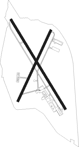
Runway info
Runway 14 / 32  | ||
| length | 1844m (6050ft) | |
| bearing | 146° / 326° | |
| width | 46m (150ft) | |
| surface | asphalt | |
| displ threshold | 75m (246ft) / 61m (200ft) | |
| blast zone | 114m (374ft) / 61m (200ft) | |
| Runway 1 / 19 | ||
| length | 1373m (4505ft) | |
| bearing | 37° / 217° | |
| width | 46m (150ft) | |
| surface | asphalt | |
Nearby beacons
| code | identifier | dist | bearing | frequency |
|---|---|---|---|---|
| ACV | ARCATA VOR/DME | 0.2 | 3° | 115.05 |
| FOT | FORTUNA VORTAC | 19.2 | 202° | 114 |
| CEC | CRESCENT CITY VORTAC | 48.5 | 351° | 109 |
Departure and arrival routes
| Transition altitude | 18000ft |
| Transition level | 18000ft |
| SID end points | distance | outbound heading | |
|---|---|---|---|
| RW01 | |||
| HOCUT5 | 19mi | 202° | |
| RW14 | |||
| HOCUT5 | 19mi | 202° | |
| RW19 | |||
| HOCUT5 | 19mi | 202° | |
| RW32 | |||
| HOCUT5 | 19mi | 202° | |
Instrument approach procedures
| runway | airway (heading) | route (dist, bearing) |
|---|---|---|
| RW01 | SEGVE (37°) | SEGVE 3000ft |
| RNAV | SEGVE 3000ft OGMOW (6mi, 37°) 1900ft KACV (6mi, 37°) 230ft (6909mi, 108°) 622ft HIPGI (6906mi, 288°) CULDU (11mi, 304°) 3200ft CULDU (turn) | |
| RW14 | CULDU (146°) | CULDU 3000ft |
| RNAV | CULDU 3000ft UYFOR (6mi, 146°) 2100ft KACV (6mi, 146°) 235ft (6909mi, 108°) 455ft SEGVE (6919mi, 288°) 3000ft SEGVE (turn) | |
| RW32 | ACV (183°) | ACV VOMAC (19mi, 146°) 5700ft VOMAC (turn) 5700ft |
| RW32 | FOT (22°) | FOT VOMAC (14mi, 84°) 5700ft VOMAC (turn) 5700ft |
| RW32 | HOCUT (89°) | HOCUT VOMAC (22mi, 131°) 5700ft VOMAC (turn) 5700ft |
| RW32 | YAGER (326°) | YAGER VOMAC (10mi, 326°) 5700ft |
| RNAV | VOMAC 5700ft JEBGA (3mi, 326°) 4700ft SAWGU (3mi, 326°) 3700ft VOLEW (2mi, 326°) 3200ft ZUVKU (3mi, 326°) 2300ft ULAMY (1mi, 326°) 1860ft KACV (5mi, 326°) 268ft (6909mi, 108°) 441ft CULDU (6910mi, 288°) 3000ft CULDU (turn) |
Disclaimer
The information on this website is not for real aviation. Use this data with the X-Plane flight simulator only! Data taken with kind consent from X-Plane 12 source code and data files. Content is subject to change without notice.