Atlantic City - Atlantic City Intl
Airport details
| Country | United States of America |
| State | New Jersey |
| Region | K6 |
| Airspace | Washington Ctr |
| Municipality | Egg Harbor Township |
| Elevation | 75ft (23m) |
| Timezone | GMT -5 |
| Coordinates | 39.45758, -74.57716 |
| Magnetic var | |
| Type | land |
| Available since | X-Plane v10.30 |
| ICAO code | KACY |
| IATA code | ACY |
| FAA code | ACY |
Communication
| Atlantic City Intl ATIS | 125.725 |
| Atlantic City Intl Clearance DEL | 127.850 |
| Atlantic City Intl Ground Control | 121.900 |
| Atlantic City Intl Tower | 120.300 |
| Atlantic City Intl Approach/Departure | 134.250 |
| Atlantic City Intl Approach/Departure | 124.600 |
Approach frequencies
| ILS-cat-I | RW31 | 109.1 | 18.00mi |
| ILS-cat-I | RW13 | 109.1 | 18.00mi |
| 3° GS | RW31 | 109.1 | 18.00mi |
| 3° GS | RW13 | 109.1 | 18.00mi |
Nearby Points of Interest:
Amanda Blake Store
-Port Republic Historic District
-Smithville Apothecary
-Mays Landing Presbyterian Church
-Belcoville Post Office
-Boardwalk Hall
-Somers Mansion
-Segal Building
-Church of the Ascension
-Ocean City Residential Historic District
-Ocean City Tenth Street Station
-Ocean City City Hall
-Thomas Beesley Sr. House
-Ocean City 34th Street Station
-Marshallville Historic District
-South Tuckahoe Historic District
-Tuckahoe Station
-Little Egg Harbor Friends Meeting House
-Head of the River Church
-John Wesley Gandy House
-Jacobus Evangelical Lutheran Church
-Beach Haven Historic District
-Reeves-Iszard-Godfey House
-Woodbine Brotherhood Synagogue
-Calvary Baptist Church
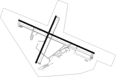
Runway info
Runway 13 / 31  | ||
| length | 3044m (9987ft) | |
| bearing | 112° / 292° | |
| width | 46m (151ft) | |
| surface | asphalt | |
| blast zone | 61m (200ft) / 61m (200ft) | |
| Runway 4 / 22 | ||
| length | 1874m (6148ft) | |
| bearing | 34° / 214° | |
| width | 46m (151ft) | |
| surface | asphalt | |
| blast zone | 0m (0ft) / 61m (200ft) | |
Nearby beacons
| code | identifier | dist | bearing | frequency |
|---|---|---|---|---|
| ACY | ATLANTIC CITY VORTAC | 0.1 | 154° | 108.60 |
| VCN | CEDAR LAKE (MILLVILLE) VOR/DME | 18.7 | 282° | 115.20 |
| CYN | COYLE VORTAC | 22.6 | 22° | 113.40 |
| SIE | SEA ISLE VORTAC | 24 | 212° | 114.80 |
| RNB | RAINBOW (MILLVILLE) NDB | 25.9 | 266° | 363 |
| GXU | MC GUIRE (WRIGHTSTOWN) VORTAC | 33.1 | 358° | 110.60 |
| OOD | WOODSTOWN VORTAC | 35.2 | 284° | 112.80 |
| NEL | LAKEHURST TACAN | 36.3 | 21° | 111.80 |
| NEL | LAKEHURST NDB | 36.9 | 22° | 396 |
| RBV | ROBBINSVILLE VORTAC | 44.8 | 6° | 113.80 |
| ENO | SMYRNA (KENTON) VORTAC | 45.6 | 256° | 111.40 |
| DOV | DOVER TACAN | 45.7 | 250° | 110 |
| ATR | WATERLOO VOR/DME | 48.8 | 224° | 112.60 |
| ARD | YARDLEY VOR/DME | 50.1 | 337° | 108.20 |
| ING | AMBLER NDB | 51.7 | 313° | 275 |
| COL | COLTS NECK VOR/DME | 54.7 | 26° | 115.40 |
| PTW | POTTSTOWN VORTAC | 64.5 | 308° | 116.50 |
Instrument approach procedures
| runway | airway (heading) | route (dist, bearing) |
|---|---|---|
| RW04 | DAYAD (350°) | DAYAD 3500ft JEDOB (10mi, 292°) 2000ft |
| RW04 | JEDOB (35°) | JEDOB 2000ft |
| RW04 | WYLEA (70°) | WYLEA 2100ft JEDOB (10mi, 112°) 2000ft |
| RNAV | JEDOB 2000ft FASEN (8mi, 34°) 1700ft TEMVE (4mi, 34°) 520ft KACY (2mi, 38°) 108ft (4694mi, 118°) 600ft SMITS (4683mi, 298°) 2000ft SMITS (turn) | |
| RW13-Y | CARYL (113°) | CARYL 2000ft |
| RW13-Y | KOVEC (90°) | KOVEC 2000ft CARYL (6mi, 34°) 2000ft |
| RW13-Y | WAGIR (139°) | WAGIR 2000ft CARYL (6mi, 214°) 2000ft |
| RNAV | CARYL 2000ft MAYBN (6mi, 112°) 1600ft KACY (5mi, 113°) 133ft JURAD (7mi, 112°) RODDI (8mi, 71°) 2000ft RODDI (turn) | |
| RW13-Z | LEBVE (141°) | LEBVE CARYL (7mi, 206°) 2000ft |
| RW13-Z | VCN (102°) | VCN CARYL (8mi, 87°) 2000ft |
| RNAV | CARYL 2000ft MAYBN (6mi, 112°) 1600ft KACY (5mi, 113°) 133ft JURAD (7mi, 112°) RODDI (8mi, 71°) 2000ft RODDI (turn) | |
| RW22 | VCN (102°) | VCN PIDVE (17mi, 72°) 1800ft KOPCE (6mi, 108°) 1800ft |
| RNAV | KOPCE 1800ft FLDER (4mi, 197°) 1600ft EFEWY (2mi, 197°) 1100ft KACY (4mi, 212°) 118ft (4694mi, 118°) 600ft TUBER (4701mi, 298°) 2000ft TUBER (turn) | |
| RW31-Y | PANZE (242°) | PANZE RODDI (15mi, 209°) 2000ft STEVV (6mi, 215°) 2000ft |
| RW31-Y | SIE (32°) | SIE JENGA (21mi, 65°) 2000ft STEVV (6mi, 35°) 2000ft |
| RNAV | STEVV 2000ft PRSTY (6mi, 293°) 1700ft YIBKU (2mi, 292°) 1000ft KACY (4mi, 292°) 115ft WEREK (6mi, 293°) KOVEC (8mi, 253°) 2000ft KOVEC (turn) | |
| RW31-Z | PANZE (242°) | PANZE RODDI (15mi, 209°) 2000ft STEVV (6mi, 215°) 2000ft |
| RW31-Z | SIE (32°) | SIE JENGA (21mi, 65°) 2000ft STEVV (6mi, 35°) 2000ft |
| RNAV | STEVV 2000ft PRSTY (6mi, 293°) 1700ft KACY (6mi, 292°) 115ft WEREK (6mi, 293°) KOVEC (8mi, 253°) 2000ft KOVEC (turn) |
Disclaimer
The information on this website is not for real aviation. Use this data with the X-Plane flight simulator only! Data taken with kind consent from X-Plane 12 source code and data files. Content is subject to change without notice.