Ada - Ada Muni
Airport details
| Country | United States of America |
| State | Oklahoma |
| Region | K4 |
| Airspace | Ft Worth Ctr |
| Municipality | Ada |
| Elevation | 1016ft (310m) |
| Timezone | GMT -6 |
| Coordinates | 34.80403, -96.67125 |
| Magnetic var | |
| Type | land |
| Available since | X-Plane v10.30 |
| ICAO code | KADH |
| IATA code | ADT |
| FAA code | ADH |
Communication
| Ada Muni AWOS 3 | 118.725 |
| Ada Muni CTAF/UNICOM | 122.800 |
| Ada Muni Approach/Departure Fort Worth ARTCC | 132.200 |
Nearby Points of Interest:
Pontotoc County Courthouse
-Sugg Clinic
-Ada Arts and Heritage Center
-Wintersmith Park Historic District
-First National Bank Building
-Holdenville City Hall
-Holdenville Armory
-Seminole County Courthouse
-Murray County Courthouse
-Strother Memorial Chapel
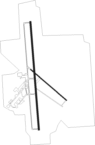
Runway info
Runway 18 / 36  | ||
| length | 1902m (6240ft) | |
| bearing | 180° / 360° | |
| width | 30m (100ft) | |
| surface | asphalt | |
| displ threshold | 0m (0ft) / 33m (108ft) | |
| Runway 13 / 31 | ||
| length | 827m (2713ft) | |
| bearing | 130° / 310° | |
| width | 17m (54ft) | |
| surface | asphalt | |
| blast zone | 15m (49ft) / 0m (0ft) | |
Nearby beacons
| code | identifier | dist | bearing | frequency |
|---|---|---|---|---|
| SRE | SEMINOLE NDB | 28 | 360° | 278 |
| AI | ADDMO (ARDMORE) NDB | 36.6 | 205° | 400 |
| ADM | ARDMORE VORTAC | 43.2 | 220° | 116.70 |
| MLC | MCALESTER TACAN | 43.9 | 87° | 112 |
| HET | HENRYETTA NDB | 48.4 | 48° | 267 |
| TIK | TINKER (OKLAHOMA CITY) TACAN | 51.5 | 312° | 115.80 |
| URH | (DURANT) DME | 53.4 | 162° | 114.30 |
| RG | GALLY (OKLAHOMA CITY) NDB | 53.8 | 298° | 350 |
| IRW | WILL ROGERS (OKLAHOMA CIT VORTAC | 56.8 | 301° | 114.10 |
| DNI | DENISON (SHERMAN-DENISON) NDB | 58.7 | 180° | 341 |
| PWA | WILEY POST (OKLAHOMA CITY VOR/DME | 64.8 | 307° | 113.40 |
| OKM | OKMULGEE VOR/DME | 66.4 | 42° | 114.90 |
| OK | PRESO (OKMULGEE) NDB | 67.2 | 37° | 388 |
Instrument approach procedures
| runway | airway (heading) | route (dist, bearing) |
|---|---|---|
| RW18 | AFSUJ (139°) | AFSUJ FEKVO (8mi, 90°) 3000ft |
| RW18 | FEKVO (180°) | FEKVO 3000ft |
| RW18 | PRARE (221°) | PRARE FEKVO (8mi, 270°) 3000ft |
| RNAV | FEKVO 3000ft CEKOX (6mi, 180°) 2500ft RECIT (2mi, 180°) 1800ft KADH (3mi, 179°) 1071ft (5734mi, 110°) 1266ft TANPY (5735mi, 290°) 3000ft TANPY (turn) | |
| RW36 | HELKU (41°) | HELKU TANPY (8mi, 90°) 3000ft |
| RW36 | JESAB (319°) | JESAB TANPY (8mi, 270°) 3000ft |
| RW36 | TANPY (0°) | TANPY 3000ft |
| RNAV | TANPY 3000ft BETLY (6mi, 360°) 2500ft OBRUE (2mi, 360°) 1780ft KADH (3mi, 1°) 1016ft (5734mi, 110°) 1245ft FEKVO (5733mi, 290°) 3000ft FEKVO (turn) |
Disclaimer
The information on this website is not for real aviation. Use this data with the X-Plane flight simulator only! Data taken with kind consent from X-Plane 12 source code and data files. Content is subject to change without notice.