Audubon - Audubon Co
Airport details
| Country | United States of America |
| State | Iowa |
| Region | K3 |
| Airspace | Minneapolis Ctr |
| Municipality | Audubon County |
| Elevation | 1287ft (392m) |
| Timezone | GMT -6 |
| Coordinates | 41.70153, -94.92044 |
| Magnetic var | |
| Type | land |
| Available since | X-Plane v10.40 |
| ICAO code | KADU |
| IATA code | n/a |
| FAA code | ADU |
Communication
| Audubon Co AWOS 3 | 118.075 |
| Audubon Co CTAF/UNICOM | 122.800 |
Nearby Points of Interest:
Audubon County Court House
-John D. Bush House
-Hans J. Jorgensen Barn
-Kimballton Commercial District
-Kimballton West 2nd – West 3rd Street Residential District
-Irwin Consolidated School
-Floral Hall
-Chicago, Rock Island & Pacific Railroad Depot
-Job A. and Rebecca E. McWaid House
-American Legion Memorial Building
-Hotel Whitney
-Shelby County Courthouse
-Cass County Courthouse
-Nishnabotna River Bridge
-Charles F. and Ruth Chase House
-German Bank Building of Walnut, Iowa
-George Rewerts House
-Chicago & Northwestern Passenger Depot and Baggage Room-Carroll
-Charles Henry and Charlotte Norton House
-Pottawattamie County Sub Courthouse
-Nishnabotna Ferry House
-Clarence D. Chamberlin House
-Carey House, Denison, Iowa
-William A. McHenry House
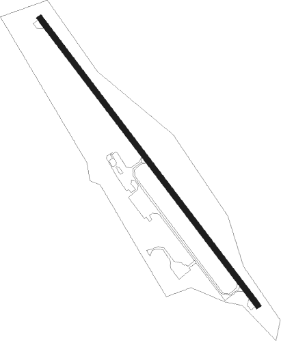
Runway info
| Runway 14 / 32 | ||
| length | 1109m (3638ft) | |
| bearing | 139° / 319° | |
| width | 18m (60ft) | |
| surface | concrete | |
| displ threshold | 43m (141ft) / 0m (0ft) | |
Nearby beacons
| code | identifier | dist | bearing | frequency |
|---|---|---|---|---|
| EFW | JEFFERSON NDB | 31.9 | 62° | 391 |
| OVR | OMAHA VORTAC | 48.7 | 237° | 116.30 |
| FO | BARRO (FORT DODGE) NDB | 55.9 | 37° | 341 |
| OFF | OFFUTT (OMAHA) TACAN | 56.3 | 239° | 111.70 |
| FOD | FORT DODGE VORTAC | 61.3 | 35° | 113.50 |
| PMV | PLATTSMOUTH NDB | 63.8 | 233° | 329 |
Instrument approach procedures
| runway | airway (heading) | route (dist, bearing) |
|---|---|---|
| RW32 | BOPKE (350°) | BOPKE TUYMO (5mi, 64°) 3000ft |
| RW32 | CALUR (295°) | CALUR TUYMO (5mi, 244°) 3000ft |
| RW32 | TUYMO (319°) | TUYMO 3000ft |
| RNAV | TUYMO 3000ft OMHIH (5mi, 319°) 3000ft NINNY (4mi, 319°) 1800ft KADU (2mi, 319°) 1317ft (5626mi, 114°) 2500ft TUYMO (5620mi, 294°) 3000ft TUYMO (turn) |
Disclaimer
The information on this website is not for real aviation. Use this data with the X-Plane flight simulator only! Data taken with kind consent from X-Plane 12 source code and data files. Content is subject to change without notice.