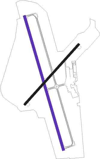
Albert Lea - Albert Lea Mun
Airport details
| Country | United States of America |
| State | Minnesota |
| Region | K3 |
| Airspace | Minneapolis Ctr |
| Municipality | Albert Lea |
| Elevation | 1261ft (384m) |
| Timezone | GMT -6 |
| Coordinates | 43.68131, -93.36815 |
| Magnetic var | |
| Type | land |
| Available since | X-Plane v10.30 |
| ICAO code | KAEL |
| IATA code | AEL |
| FAA code | AEL |
Communication
| Albert Lea Mun AWOS-3 | 109.800 |
| Albert Lea Mun ALBERT LEA MUN UNICOM | 123.000 |
| Albert Lea Mun ROCHESTER Approach / Depature | 119.800 |
Nearby Points of Interest:
Clarks Grove Cooperative Creamery
-Strangers Refuge Lodge Number 74, IOOF
-Worth County Courthouse
-Old Worth County Courthouse
-Chicago, Milwaukee, St. Paul and Pacific Depot and Lunchroom
-Hormel Historic Home
-Vista Lutheran Church
-First Methodist Episcopal Church
-Otranto Bridge
-Roscoe P. Ward House
-W. J. Armstrong Company Wholesale Grocers Building
-William R. Wolf House
-Philo C. Bailey House
-Waseca County Courthouse
-Steele County Courthouse
-Pillsbury Baptist Bible College
-Owatonna City and Firemen's Hall
-Owatonna Commercial Historic District
-Ezra Abbott House
-Owatonna Public Library
-Dr. John H. Adair House
-Minnesota State Public School for Dependent and Neglected Children
-Rhodes Mill
-Winnebago County Courthouse
-First National Bank of Adams
Nearby beacons
| code | identifier | dist | bearing | frequency |
|---|---|---|---|---|
| AEL | ALBERT LEA VOR/DME | 0.1 | 279° | 109.80 |
| JAY | AUSTIN VOR/DME | 20.5 | 103° | 108.20 |
| OW | TONNA (OWATONNA) NDB | 25.3 | 28° | 379 |
| FOW | HALFWAY (MORRISTOWN) VOR/DME | 31.4 | 360° | 111.20 |
| RST | ROCHESTER VOR/DME | 34 | 82° | 112 |
| MCW | MASON CITY VOR/DME | 35.2 | 176° | 114.90 |
| MC | SURFF (MASON CITY) NDB | 37.8 | 176° | 348 |
| MKT | MANKATO VOR/DME | 39.9 | 315° | 110.80 |
| FQ | MONTZ (FAIRMONT) NDB | 41.7 | 264° | 420 |
| IY | CHUKK (CHARLES CITY) NDB | 43.1 | 131° | 417 |
| FGT | FARMINGTON VORTAC | 57.5 | 11° | 115.70 |
| RG | REGUE (RED WING) NDB | 63.2 | 38° | 274 |
Instrument approach procedures
| runway | airway (heading) | route (dist, bearing) |
|---|---|---|
| RW17 | ALMAY (150°) | ALMAY BOYAY (13mi, 140°) 2900ft |
| RW17 | FREED (107°) | FREED BOYAY (9mi, 26°) 2900ft BOYAY (turn) 2900ft |
| RW17 | KASPR (203°) | KASPR BOYAY (10mi, 241°) 2900ft |
| RW17 | NEWRY (241°) | NEWRY BOYAY (10mi, 311°) 2900ft BOYAY (turn) 2900ft |
| RNAV | BOYAY 2900ft SAPOC (6mi, 164°) 2900ft BUNSE (3mi, 164°) 1860ft KAEL (2mi, 163°) 1310ft (5551mi, 115°) 1510ft YEDUT (5550mi, 295°) 2900ft YEDUT (turn) | |
| RW35 | GOTHE (329°) | GOTHE YEDUT (3mi, 213°) 2900ft YEDUT (turn) 2900ft |
| RW35 | HIBLO (28°) | HIBLO YEDUT (6mi, 106°) 2900ft YEDUT (turn) 2900ft |
| RW35 | MCW (356°) | MCW YEDUT (24mi, 2°) 2900ft |
| RNAV | YEDUT 2900ft ZUTIX (6mi, 344°) 2800ft BIGKA (3mi, 344°) 1880ft KAEL (2mi, 345°) 1311ft (5551mi, 115°) 1511ft BOYAY (5553mi, 295°) 2900ft BOYAY (turn) |
Disclaimer
The information on this website is not for real aviation. Use this data with the X-Plane flight simulator only! Data taken with kind consent from X-Plane 12 source code and data files. Content is subject to change without notice.

