Avon Park - Macdill Afb Aux Fld
Airport details
| Country | United States of America |
| State | Florida |
| Region | K7 |
| Airspace | Miami Oceanic Ctr |
| Municipality | Polk County |
| Elevation | 66ft (20m) |
| Timezone | GMT -5 |
| Coordinates | 27.64785, -81.34156 |
| Magnetic var | |
| Type | land |
| Available since | X-Plane v10.40 |
| ICAO code | KAGR |
| IATA code | n/a |
| FAA code | AGR |
Communication
Nearby Points of Interest:
Avon Park Historic District
-Elizabeth Haines House
-Central Station
-Sebring Downtown Historic District
-Highlands County Courthouse
-Paul L. Vinson House
-Edward Hainz House
-H. Orvel Sebring House
-Harder Hall
-Babson Park Woman's Club
-Casa De Josefina
-Church of the Holy Spirit
-B. K. Bullard House
-First Baptist Church
-Lake Wales City Hall
-Lake Wales Historic Residential District
-Lake Wales Commercial Historic District
-G. V. Tillman House
-C. L. Johnson House
-North Avenue Historic District
-Old Lake Placid Atlantic Coast Line Railroad Depot
-El Retiro
-Mountain Lake Estates Historic District
-Mountain Lake Colony House
-Lake of the Hills Community Club
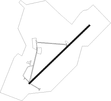
Runway info
| Runway 5 / 23 | ||
| length | 2441m (8009ft) | |
| bearing | 54° / 234° | |
| width | 46m (150ft) | |
| surface | asphalt | |
| blast zone | 255m (837ft) / 255m (837ft) | |
Nearby beacons
| code | identifier | dist | bearing | frequency |
|---|---|---|---|---|
| LAL | LAKELAND VORTAC | 41 | 297° | 116 |
| TRV | TREASURE (VERO BEACH) VORTAC | 45.3 | 88° | 117.30 |
| MLB | MELBOURNE VOR/DME | 46.4 | 57° | 115.85 |
| LBV | LA BELLE VORTAC | 49.2 | 183° | 110.40 |
| OR | HERNY (ORLANDO) NDB | 51.8 | 354° | 221 |
| COF | PATRICK (COCOA) TACAN | 52.4 | 51° | 115 |
| FPR | FORT PIERCE NDB | 52.4 | 99° | 275 |
| ORL | ORLANDO VORTAC | 53.7 | 0° | 112.20 |
| PGD | PUNTA GORDA VOR | 55.9 | 222° | 110.20 |
| PHK | PAHOKEE VOR/DME | 62.4 | 143° | 115.40 |
Disclaimer
The information on this website is not for real aviation. Use this data with the X-Plane flight simulator only! Data taken with kind consent from X-Plane 12 source code and data files. Content is subject to change without notice.