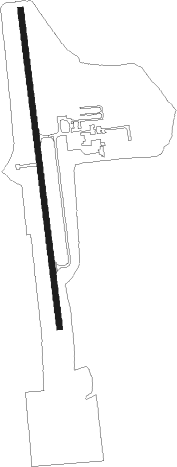
Alexander City - Thomas C Russell Fld
Airport details
| Country | United States of America |
| State | Alabama |
| Region | K7 |
| Airspace | Atlanta Ctr |
| Municipality | Alexander City |
| Elevation | 686ft (209m) |
| Timezone | GMT -5 |
| Coordinates | 32.91475, -85.96294 |
| Magnetic var | |
| Type | land |
| Available since | X-Plane v10.40 |
| ICAO code | KALX |
| IATA code | ALX |
| FAA code | ALX |
Communication
| THOMAS C RUSSELL FLD AWOS 3 | 118.325 |
| THOMAS C RUSSELL FLD CTAF/UNICOM | 122.700 |
| THOMAS C RUSSELL FLD MONTGOMERY Approach/Departure | 121.200 |
Nearby Points of Interest:
Russell Family Historic District
-Alexander City Commercial Historic District
-A.J. and Emma E. Thomas Coley House
-Reuben Herzfeld House
-Pinhoti National Recreation Trail
-B. B. Comer Memorial Library
-Clay County Courthouse
-Tallassee Mills
-Wadley Railroad Depot
-Wetumpka State Penitentiary
-First United Methodist Church
-First Presbyterian Church of Wetumpka
-Shiloh Missionary Baptist Church and Rosenwald School
-Chambers County Courthouse Square Historic District
-Orange Vale
-Fort Toulouse
-Verbena
-Noble Hall
-Auburn City Hall
-Cater Hall
-Thornhill
-Auburn University Chapel
-Tuskegee Veterans Administration Medical Center
-Old Rotation
-Pebble Hill
Nearby beacons
| code | identifier | dist | bearing | frequency |
|---|---|---|---|---|
| TGE | TUSKEGEE VOR/DME | 29.7 | 146° | 117.30 |
| AN | BOGGA (ANNISTON) NDB | 37.2 | 3° | 211 |
| MXF | MAXWELL (MONTGOMERY) TACAN | 38.1 | 217° | 115 |
| LGC | LA GRANGE VORTAC | 38.9 | 80° | 115.60 |
| TDG | DME | 39.8 | 353° | 108.80 |
| MGM | MONTGOMERY VORTAC | 45.3 | 207° | 112.10 |
| MG | MARRA (MONTGOMERY) NDB | 45.6 | 222° | 245 |
| CSG | COLUMBUS VORTAC | 51 | 108° | 117.10 |
| CS | FENIX (COLUMBUS) NDB | 54.2 | 117° | 355 |
| BH | MCDEN (BIRMINGHAM) NDB | 57 | 304° | 224 |
| GPQ | CARROLLTON NDB | 57.2 | 52° | 278 |
| LSF | LAWSON (COLUMBUS) VOR/DME | 60.2 | 121° | 111.40 |
| AWS | LAWSON (COLUMBUS) NDB | 60.4 | 124° | 335 |
| SE | POLLK (SELMA) NDB | 62.3 | 236° | 344 |
| VUZ | VULCAN (BIRMINGHAM) VORTAC | 65.3 | 309° | 114.40 |
| EUF | EUFAULA VORTAC | 71.6 | 139° | 109.20 |
Instrument approach procedures
| runway | airway (heading) | route (dist, bearing) |
|---|---|---|
| RW18 | JOPIB (177°) | JOPIB 3600ft |
| RNAV | JOPIB 3600ft KUCEG (5mi, 177°) 2700ft WALNI (4mi, 177°) 1400ft KALX (2mi, 177°) 732ft (5202mi, 111°) 1061ft TATME (5201mi, 291°) 3000ft TATME (turn) | |
| RW36 | TATME (357°) | TATME 3000ft |
| RNAV | TATME 3000ft BILLP (6mi, 357°) 2500ft JUBKI (3mi, 357°) 1380ft KALX (3mi, 357°) 662ft (5202mi, 111°) 1100ft TATME (5201mi, 291°) 3000ft TATME (turn) |
Disclaimer
The information on this website is not for real aviation. Use this data with the X-Plane flight simulator only! Data taken with kind consent from X-Plane 12 source code and data files. Content is subject to change without notice.
