Chicago/aurora - Aurora Muni
Airport details
| Country | United States of America |
| State | Illinois |
| Region | K5 |
| Airspace | Chicago Ctr |
| Municipality | Sugar Grove Township |
| Elevation | 708ft (216m) |
| Timezone | GMT -6 |
| Coordinates | 41.77192, -88.47567 |
| Magnetic var | |
| Type | land |
| Available since | X-Plane v10.40 |
| ICAO code | KARR |
| IATA code | AUZ |
| FAA code | ARR |
Communication
| Aurora Muni ATIS | 125.850 |
| Aurora Muni CTAF | 120.600 |
| Aurora Muni UNICOM | 122.950 |
| Aurora Muni Ground Control | 121.700 |
| Aurora Muni Tower | 120.600 |
| Aurora Muni Approach | 133.500 |
| Aurora Muni Departure | 133.500 |
Approach frequencies
| LOC | RW33 | 111.15 | 18.00mi |
| ILS-cat-I | RW09 | 108.9 | 18.00mi |
| 3° GS | RW09 | 108.9 | 18.00mi |
Nearby Points of Interest:
Ephraim Smith House
-Gray–Watkins Mill
-Stearns–Wadsworth House
-Sam and Ruth VanSickle Ford House
-Col. Ira C. Copley Mansion
-West Side Historic District
-Albert H. Sears House
-Lewis Steward House
-Healy Chapel
-Old Second National Bank
-Aurora Elks Lodge No. 705
-Stolp Woolen Mill Store
-Graham Building
-Keystone Building
-Copley Hospital
-Hotel Arthur
-LaSalle Street Auto Row Historic District
-Masonic Temple
-Bristol Congregational Church
-Fox River Pavilion
-Kendall County Courthouse
-Batavia Institute
-First Methodist Church of Batavia
-Mrs. A. W. Gridley House
-Louise White School
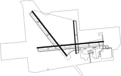
Runway info
Runway 9 / 27  | ||
| length | 1980m (6496ft) | |
| bearing | 89° / 269° | |
| width | 30m (100ft) | |
| surface | concrete | |
| blast zone | 0m (0ft) / 152m (499ft) | |
| Runway 18 / 36 | ||
| length | 976m (3202ft) | |
| bearing | 180° / 360° | |
| width | 23m (75ft) | |
| surface | concrete | |
| Runway 15 / 33 | ||
| length | 1677m (5502ft) | |
| bearing | 139° / 319° | |
| width | 30m (100ft) | |
| surface | concrete | |
Nearby beacons
| code | identifier | dist | bearing | frequency |
|---|---|---|---|---|
| DPA | DUPAGE (CHICAGO) VOR/DME | 9 | 47° | 108.40 |
| JOT | JOLIET VOR/DME | 15.2 | 145° | 112.30 |
| GCO | DME | 28.9 | 69° | 108.25 |
| MX | KEDZI (CHICAGO) NDB | 35.2 | 92° | 248 |
| OBK | NORTHBROOK VOR/DME | 35.7 | 49° | 113 |
| DTG | DWIGHT NDB | 38.3 | 176° | 344 |
| RFD | DME | 42.2 | 302° | 110.80 |
| EON | PEOTONE VORTAC | 43.1 | 126° | 113.20 |
| CGT | CHICAGO HEIGHTS VORTAC | 43.5 | 106° | 114.20 |
| IKK | DME | 50.4 | 138° | 111.60 |
| UG | WAUKE (CHICAGO/WAUKEGAN) NDB | 51.2 | 44° | 379 |
| IK | LUKOW (KANKAKEE) NDB | 52.1 | 143° | 272 |
| JVL | JANESVILLE VOR/DME | 54.9 | 321° | 114.30 |
| ENW | DME | 55.2 | 33° | 109.20 |
| BUU | (BURLINGTON) DME | 55.6 | 11° | 114.50 |
| PNT | PONTIAC VOR/DME | 58.2 | 195° | 109.60 |
| RA | PASER (RACINE) NDB | 60.3 | 32° | 206 |
| HRK | (RACINE) DME | 66.3 | 34° | 117.70 |
Departure and arrival routes
| Transition altitude | 18000ft |
| Transition level | 18000ft |
| SID end points | distance | outbound heading | |
|---|---|---|---|
| RW09 | |||
| ELANR6 | 124mi | 143° | |
| DARCY6 | 173mi | 148° | |
| CARYN6 | 92mi | 157° | |
| BLOKR6 | 73mi | 165° | |
| ADELL6 | 88mi | 187° | |
| OBENE3 | 193mi | 283° | |
| RW15 | |||
| ELANR6 | 124mi | 143° | |
| DARCY6 | 173mi | 148° | |
| CARYN6 | 92mi | 157° | |
| BLOKR6 | 73mi | 165° | |
| ADELL6 | 88mi | 187° | |
| OBENE3 | 193mi | 283° | |
| RW18 | |||
| ELANR6 | 124mi | 143° | |
| DARCY6 | 173mi | 148° | |
| CARYN6 | 92mi | 157° | |
| BLOKR6 | 73mi | 165° | |
| ADELL6 | 88mi | 187° | |
| OBENE3 | 193mi | 283° | |
| RW27 | |||
| ELANR6 | 124mi | 143° | |
| DARCY6 | 173mi | 148° | |
| CARYN6 | 92mi | 157° | |
| BLOKR6 | 73mi | 165° | |
| ADELL6 | 88mi | 187° | |
| OBENE3 | 193mi | 283° | |
| RW33 | |||
| ELANR6 | 124mi | 143° | |
| DARCY6 | 173mi | 148° | |
| CARYN6 | 92mi | 157° | |
| BLOKR6 | 73mi | 165° | |
| ADELL6 | 88mi | 187° | |
| OBENE3 | 193mi | 283° | |
| RW36 | |||
| ELANR6 | 124mi | 143° | |
| DARCY6 | 173mi | 148° | |
| CARYN6 | 92mi | 157° | |
| BLOKR6 | 73mi | 165° | |
| ADELL6 | 88mi | 187° | |
| OBENE3 | 193mi | 283° | |
Instrument approach procedures
| runway | airway (heading) | route (dist, bearing) |
|---|---|---|
| RW09 | AHMED (55°) | AHMED JUGER (12mi, 26°) 2700ft TOBBY (5mi, 12°) 2700ft |
| RW09 | HERVY (91°) | HERVY TOBBY (7mi, 94°) 2700ft |
| RW09 | NUELG (140°) | NUELG DECAK (10mi, 222°) 2700ft TOBBY (5mi, 165°) 2700ft |
| RW09 | TOBBY (89°) | TOBBY 10000ft TOBBY (turn) 2700ft |
| RNAV | TOBBY 2700ft WOLFF (6mi, 89°) 2700ft KARR (7mi, 89°) 752ft (5337mi, 115°) 957ft HOGIE (5324mi, 295°) 2500ft HOGIE (turn) | |
| RW15 | NUELG (140°) | NUELG UBEXE (4mi, 144°) 2600ft |
| RNAV | UBEXE 2600ft WUYFI (5mi, 139°) 2300ft KARR (6mi, 137°) 757ft (5337mi, 115°) 962ft UQITY (5334mi, 295°) 3000ft UQITY (turn) 3000ft | |
| RW27 | DPA (227°) | DPA HOGIE (10mi, 128°) 2500ft HOGIE (turn) 2500ft |
| RW27 | JOT (325°) | JOT CIMKO (9mi, 48°) 2500ft HOGIE (7mi, 359°) 2500ft |
| RNAV | HOGIE 2500ft KAREY (7mi, 269°) 2300ft NECLY (3mi, 269°) 1260ft KARR (2mi, 271°) 752ft (5337mi, 115°) 907ft TOBBY (5349mi, 295°) 2700ft TOBBY (turn) | |
| RW33 | JOT (325°) | JOT 2600ft BOBBB (4mi, 341°) 2600ft |
| RNAV | BOBBB 2600ft RIESR (6mi, 319°) 2300ft KARR (5mi, 320°) 747ft (5337mi, 115°) 1042ft UCORO (5340mi, 295°) 3000ft UCORO (turn) 3000ft |
Disclaimer
The information on this website is not for real aviation. Use this data with the X-Plane flight simulator only! Data taken with kind consent from X-Plane 12 source code and data files. Content is subject to change without notice.