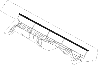
Nashua - Boire Field Nashua
Airport details
| Country | United States of America |
| State | New Hampshire |
| Region | K6 |
| Airspace | Boston Ctr |
| Municipality | Nashua |
| Elevation | 200ft (61m) |
| Timezone | GMT -5 |
| Coordinates | 42.78241, -71.51409 |
| Magnetic var | |
| Type | land |
| Available since | X-Plane v10.40 |
| ICAO code | KASH |
| IATA code | ASH |
| FAA code | ASH |
Communication
| Boire Field Nashua ATIS | 125.100 |
| Boire Field Nashua CTAF | 133.200 |
| Boire Field Nashua Ground Control/Clearance DEL | 121.800 |
| Boire Field Nashua NASHUA Tower | 133.200 |
| Boire Field Nashua BOSTON Approach/Departure | 134.750 |
| Boire Field Nashua BOSTON Approach/Departure | 124.900 |
Approach frequencies
| ILS-cat-I | RW14 | 109.7 | 18.00mi |
| 3° GS | RW14 | 109.7 | 18.00mi |
Nearby beacons
| code | identifier | dist | bearing | frequency |
|---|---|---|---|---|
| MJ | FITZY (MANCHESTER) NDB | 4.9 | 350° | 209 |
| MHT | MANCHESTER VOR/DME | 8.2 | 59° | 114.40 |
| LWM | DME | 18.6 | 96° | 112.50 |
| CO | EPSOM (CONCORD) NDB | 20.3 | 10° | 216 |
| CON | CONCORD VOR/DME | 26.4 | 352° | 112.90 |
| GDM | GARDNER VOR/DME | 27.9 | 247° | 110.60 |
| EEN | DME | 34.2 | 271° | 109.40 |
| BOS | BOSTON VOR/DME | 34.4 | 129° | 112.70 |
| PSM | (PORTSMOUTH) DME | 35 | 66° | 116.50 |
| ESG | ROLLINS (ROLLINSFORD) NDB | 39.9 | 57° | 260 |
| OW | STOGE (NORWOOD) NDB | 43.3 | 150° | 397 |
| SF | SANFD (SANFORD) NDB | 44.5 | 51° | 349 |
| LC | BLNAP (LACONIA) NDB | 45.3 | 358° | 328 |
| CNH | CLAREMONT NDB | 51.5 | 304° | 233 |
| PUT | PUTNAM VOR/DME | 51.7 | 202° | 117.40 |
| ENE | KENNEBUNK VOR/DME | 55.2 | 54° | 117.10 |
| LEB | DME | 61.9 | 322° | 113.70 |
| LAH | HANOVER (LEBANON) NDB | 62.4 | 324° | 276 |
Instrument approach procedures
| runway | airway (heading) | route (dist, bearing) |
|---|---|---|
| RW14 | CON (172°) | CON TUMAE (15mi, 203°) 3800ft MUGGY (7mi, 221°) 3800ft |
| RW14 | MUGGY (115°) | MUGGY 3800ft |
| RNAV | MUGGY 3800ft LODTI (5mi, 115°) 2500ft NORIY (3mi, 115°) 1600ft HESKO (2mi, 115°) 1000ft KASH (3mi, 115°) 247ft (4597mi, 121°) 800ft PELAN (4589mi, 301°) 2000ft PELAN (turn) | |
| RW32 | ELIRY (295°) | ELIRY 2500ft |
| RW32 | IRGAW (325°) | IRGAW ELIRY (7mi, 41°) 2500ft |
| RW32 | JEGDO (272°) | JEGDO ELIRY (7mi, 221°) 2500ft |
| RNAV | ELIRY 2500ft CORNY (6mi, 295°) 2000ft ESICU (2mi, 295°) 1220ft KASH (4mi, 295°) 236ft (4597mi, 121°) 800ft JOHNZ (4603mi, 301°) 3800ft JOHNZ (turn) 4000ft |
Disclaimer
The information on this website is not for real aviation. Use this data with the X-Plane flight simulator only! Data taken with kind consent from X-Plane 12 source code and data files. Content is subject to change without notice.
