Astoria - Astoria Rgnl
Airport details
| Country | United States of America |
| State | Oregon |
| Region | K1 |
| Airspace | Seattle Ctr |
| Municipality | Warrenton |
| Elevation | 15ft (5m) |
| Timezone | GMT -8 |
| Coordinates | 46.15797, -123.87861 |
| Magnetic var | |
| Type | land |
| Available since | X-Plane v10.32 |
| ICAO code | KAST |
| IATA code | AST |
| FAA code | AST |
Communication
| Astoria Rgnl ASOS | 135.375 |
| Astoria Rgnl CTAF/UNICOM | 122.800 |
Approach frequencies
| ILS-cat-I | RW26 | 109.5 | 18.00mi |
| 3° GS | RW26 | 109.5 | 18.00mi |
Nearby Points of Interest:
Daniel Knight Warren House
-Samuel Elmore Cannery
-George C. and Winona Flavel House
-John Hobson House
-United States Post Office
-Ferdinand Fisher House
-Norris Staples House
-Robert Rensselaer Bartlett House
-Astoria Elks Building
-Astoria Wharf and Warehouse Company
-Astoria City Hall
-Peter L. Cherry House
-Captain George Conrad Flavel House
-Old Grace Episcopal Church Rectory
-John N. Griffin House
-Albert W. Ferguson House
-Martin Foard House
-Old Astoria City Hall
-Astoria Fire House No. 2
-Peter and Maria Larson House
-Christian Leinenweber House
-MV Tourist No. 2
-Union Fishermen's Cooperative Packing Company Alderbrook Station
-Columbia River Quarantine Station
-Colbert House
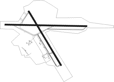
Runway info
Runway 8 / 26  | ||
| length | 1761m (5778ft) | |
| bearing | 94° / 274° | |
| width | 30m (100ft) | |
| surface | asphalt | |
| displ threshold | 91m (299ft) / 217m (712ft) | |
| Runway 14 / 32 | ||
| length | 1361m (4465ft) | |
| bearing | 145° / 325° | |
| width | 30m (100ft) | |
| surface | asphalt | |
| blast zone | 90m (295ft) / 46m (151ft) | |
Nearby beacons
| code | identifier | dist | bearing | frequency |
|---|---|---|---|---|
| AST | ASTORIA VOR/DME | 0.2 | 335° | 114 |
| PND | BANKS (PORTLAND) NDB | 47 | 122° | 356 |
| HQM | HOQUIAM VORTAC | 48.6 | 341° | 117.70 |
| UBG | NEWBERG VOR/DME | 61.3 | 132° | 117.40 |
| OLM | OLYMPIA VORTAC | 63.3 | 50° | 113.40 |
Instrument approach procedures
| runway | airway (heading) | route (dist, bearing) |
|---|---|---|
| RW08 | ILWAC (120°) | ILWAC SEAME (9mi, 162°) 2000ft |
| RNAV | SEAME 2000ft SAAND (5mi, 94°) 1700ft HISET (3mi, 94°) 680ft KAST (2mi, 95°) 50ft (6769mi, 110°) 500ft SEAME (6778mi, 290°) 2000ft SEAME (turn) | |
| RW26 | AST (155°) | AST KKARP (18mi, 94°) 5000ft KKARP (turn) 4500ft |
| RW26 | OLM (230°) | OLM HOMKU (50mi, 213°) 5400ft KKARP (5mi, 212°) 4500ft |
| RW26 | PITER (287°) | PITER SMOAK (17mi, 300°) 4500ft KKARP (5mi, 300°) 4500ft |
| RNAV | KKARP 4500ft YUZPI (6mi, 274°) 3800ft RROCK (2mi, 274°) 3500ft IPUPE (5mi, 274°) 1780ft KAST (5mi, 273°) 67ft (6769mi, 110°) 264ft STAZY (6772mi, 290°) YUXBU (7mi, 213°) KULOA (7mi, 119°) 5000ft KULOA (turn) |
Disclaimer
The information on this website is not for real aviation. Use this data with the X-Plane flight simulator only! Data taken with kind consent from X-Plane 12 source code and data files. Content is subject to change without notice.