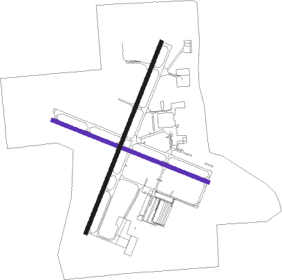
Appleton - Appleton Intl
Airport details
| Country | United States of America |
| State | Wisconsin |
| Region | K5 |
| Airspace | Minneapolis Ctr |
| Municipality | Greenville |
| Elevation | 916ft (279m) |
| Timezone | GMT -6 |
| Coordinates | 44.25808, -88.51908 |
| Magnetic var | |
| Type | land |
| Available since | X-Plane v10.32 |
| ICAO code | KATW |
| IATA code | ATW |
| FAA code | ATW |
Communication
| Appleton Intl Appleton ATIS | 127.150 |
| Appleton Intl CATF | 119.600 |
| Appleton Intl Clearance | 122.950 |
| Appleton Intl Appleton Ground | 121.700 |
| Appleton Intl Appleton Tower | 119.600 |
Approach frequencies
| ILS-cat-I | RW30 | 109.7 | 18.00mi |
| ILS-cat-I | RW03 | 109.1 | 18.00mi |
| 3° GS | RW30 | 109.7 | 18.00mi |
| 3° GS | RW03 | 109.1 | 18.00mi |
Nearby Points of Interest:
John Hart Whorton House
-Hiram Smith House
-College Avenue Historic District
-Fox River Paper Company Historic District
-George, Sr., and Ellen Banta House
-Judge J. C. Kerwin House
-Ellis Jennings House
-Henry Spencer Smith House
-Perry Lindsley House
-Main Hall
-Charles R. Smith House
-Edward D. & Vina Shattuck Beals House
-Appleton Wire Works
-Henry Sherry House
-Neenah Light
-Franklyn C. Shattuck House
-Havilah Babcock House
-George O. Bergstrom House
-Hortonville Community Hall
-Cedars Lock and Dam Historic District
-Center Valley Grade School
-Klein Dairy Farmhouse
-St. Mary's Catholic Church
-Merritt Black House
-Charles W. Stribley House
Nearby beacons
| code | identifier | dist | bearing | frequency |
|---|---|---|---|---|
| AQ | KOOKY (APPLETON) NDB | 5.7 | 109° | 407 |
| OSH | OSHKOSH VORTAC | 16.1 | 188° | 116.75 |
| GR | FAMIS (GREEN BAY) NDB | 16.2 | 57° | 356 |
| SG | DEPRE (GREEN BAY) NDB | 18.6 | 70° | 332 |
| GRB | GREEN BAY VORTAC | 22.6 | 48° | 115.50 |
| OS | POBER (OSHKOSH) NDB | 23.1 | 186° | 395 |
| MT | MAWOC (MANITOWOC) NDB | 35.3 | 94° | 362 |
| MTW | DME | 36.9 | 99° | 111 |
| FAH | (SHEBOYGAN) DME | 41.2 | 126° | 110 |
| UNU | JUNEAU NDB | 50.4 | 192° | 344 |
| BJB | WEST BEND VOR | 53 | 155° | 109.80 |
| TN | TRIBE (MENOMINEE) NDB | 59.6 | 46° | 239 |
| MNM | MENOMINEE VOR/DME | 66.7 | 43° | 109.60 |
Instrument approach procedures
| runway | airway (heading) | route (dist, bearing) |
|---|---|---|
| RW03 | APIXE (34°) | APIXE 2900ft |
| RW03 | LIMME (57°) | LIMME APIXE (5mi, 109°) 2900ft |
| RW03 | OSH (8°) | OSH APIXE (6mi, 310°) 2900ft |
| RNAV | APIXE 2900ft WUTON (6mi, 34°) 2900ft KATW (7mi, 35°) 935ft (5341mi, 117°) 1138ft ASIGE (5336mi, 297°) 2700ft ASIGE (turn) | |
| RW12 | ARALE (109°) | ARALE 2600ft |
| RW12 | GRB (228°) | GRB SOMBE (24mi, 255°) 2600ft ARALE (5mi, 214°) 2600ft |
| RW12 | OSH (8°) | OSH TISIE (20mi, 317°) 2600ft ARALE (5mi, 34°) 2600ft |
| RNAV | ARALE 2600ft ZOGLO (6mi, 109°) 2600ft HODNO (3mi, 109°) 1500ft KATW (2mi, 109°) 968ft APESE (12mi, 110°) 2700ft APESE (turn) | |
| RW21 | ASIGE (214°) | ASIGE 2700ft |
| RW21 | AUW (119°) | AUW TIDME (51mi, 109°) 2900ft ASIGE (5mi, 109°) 2700ft |
| RW21 | RABEE (269°) | RABEE WUPON (25mi, 284°) 3100ft ASIGE (5mi, 289°) 2700ft |
| RNAV | ASIGE 2700ft SEMOE (6mi, 214°) 2700ft TUCNY (4mi, 214°) 1440ft KATW (2mi, 213°) 928ft (5341mi, 117°) 1129ft APIXE (5347mi, 296°) 2900ft APIXE (turn) | |
| RW30 | APESE (290°) | APESE 2700ft |
| RW30 | GRB (228°) | GRB SUDIE (19mi, 184°) 2700ft APESE (5mi, 215°) 2700ft |
| RW30 | OSH (8°) | OSH TOMBE (12mi, 67°) 2700ft APESE (5mi, 34°) 2700ft |
| RNAV | APESE 2700ft ZUMUG (6mi, 290°) 2700ft KATW (6mi, 290°) 908ft (5341mi, 117°) 1075ft ARALE (5352mi, 297°) 2600ft ARALE (turn) |
Disclaimer
The information on this website is not for real aviation. Use this data with the X-Plane flight simulator only! Data taken with kind consent from X-Plane 12 source code and data files. Content is subject to change without notice.

