Wausau - Wausau Downtown
Airport details
| Country | United States of America |
| State | Wisconsin |
| Region | K5 |
| Airspace | Minneapolis Ctr |
| Municipality | Wausau |
| Elevation | 1201ft (366m) |
| Timezone | GMT -6 |
| Coordinates | 44.92628, -89.62701 |
| Magnetic var | |
| Type | land |
| Available since | X-Plane v10.40 |
| ICAO code | KAUW |
| IATA code | AUW |
| FAA code | AUW |
Communication
| Wausau Downtown ASOS | 125.925 |
| Wausau Downtown CTAF/UNICOM | 122.700 |
| Wausau Downtown Minneapolis | 124.400 |
Nearby Points of Interest:
Louis Marchetti House
-Duey and Julia Wright House
-Marathon County Fairgrounds
-Hiram C. Stewart House
-Granville D. Jones House
-C. H. Wegner House
-Ely Wright House
-E.K. Schuetz House
-C. B. Bird House
-C. F. Dunbar House
-D. C. Everest House
-Karl Mathie House
-Joseph Dessert Library
-Fromm Brothers Fur and Ginseng Farm
-Merrill City Hall
-First Street Bridge (Merrill, Wisconsin)
-T.B. Scott Free Library
-Antigo Opera House
-Antigo Depot
-Antigo Post Office
-Antigo Public Library and Deleglise Cabin
-Langlade County Courthouse
-Willard D. Purdy Junior High and Vocational School
-Old Plover Methodist Church
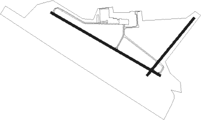
Runway info
Runway 13 / 31  | ||
| length | 1583m (5194ft) | |
| bearing | 116° / 296° | |
| width | 30m (100ft) | |
| surface | asphalt | |
| Runway 5 / 23 | ||
| length | 928m (3045ft) | |
| bearing | 54° / 234° | |
| width | 30m (100ft) | |
| surface | asphalt | |
| blast zone | 65m (213ft) / 51m (167ft) | |
| Runway 12 / 30 | ||
| length | 2440m (8005ft) | |
| bearing | 119° / 299° | |
| width | 91m (300ft) | |
Nearby beacons
| code | identifier | dist | bearing | frequency |
|---|---|---|---|---|
| AUW | WAUSAU VOR/DME | 5 | 153° | 111.60 |
| RH | ARSHA (RHINELANDER) NDB | 42.1 | 1° | 272 |
| RHI | RHINELANDER VOR/DME | 43 | 13° | 109.20 |
| DO | DOUGY (MINOCQUA WOODRUFF) NDB | 54.7 | 354° | 236 |
| DAF | NECEDAH NDB | 57 | 207° | 233 |
| VOK | VOLK (CAMP DOUGLAS) TACAN | 64.9 | 213° | 110.40 |
Instrument approach procedures
| runway | airway (heading) | route (dist, bearing) |
|---|---|---|
| RW13 | FALET (115°) | FALET 3600ft |
| RNAV | FALET 3600ft HAKMO (7mi, 116°) 3000ft JALER (3mi, 116°) 1900ft KAUW (3mi, 114°) 1235ft (5389mi, 117°) 1800ft ZUPIG (5385mi, 297°) 4000ft ZUPIG (turn) | |
| RW31 | CHURP (287°) | CHURP HUXIS (19mi, 282°) 3600ft |
| RW31 | HUXIS (296°) | HUXIS 3600ft |
| RNAV | HUXIS 3600ft ZEDNI (7mi, 296°) 3000ft CILSU (3mi, 296°) 1900ft KAUW (2mi, 297°) 1234ft (5389mi, 117°) 1700ft ZUPIG (5385mi, 297°) 4000ft ZUPIG (turn) |
Disclaimer
The information on this website is not for real aviation. Use this data with the X-Plane flight simulator only! Data taken with kind consent from X-Plane 12 source code and data files. Content is subject to change without notice.