Tucson - Marana Regl
Airport details
| Country | United States of America |
| State | Arizona |
| Region | K2 |
| Airspace | Albuquerque Ctr |
| Municipality | Marana |
| Elevation | 2028ft (618m) |
| Timezone | GMT -7 |
| Coordinates | 32.40956, -111.21839 |
| Magnetic var | |
| Type | land |
| Available since | X-Plane v10.40 |
| ICAO code | KAVQ |
| IATA code | AVW |
| FAA code | AVQ |
Communication
| Marana Regl AWOS 3 | 118.375 |
| Marana Regl CTAF/UNICOM | 123.000 |
| Marana Regl TUCSON Approach/Departure | 119.400 |
Nearby Points of Interest:
USDA Tucson Plant Materials Center
-Miracle Mile Historic District
-St. Philip's in the Hills Episcopal Church
-Copper Bell Bed and Breakfast
-Stone Avenue Underpass
-El Paso and Southwestern Railroad Depot
-Barrio El Membrillo Historic District
-Pima County Courthouse
-Fox Commercial Building
-Sosa-Carrillo-Fremont House
-Valley National Bank Building
-James A. Walsh United States Courthouse
-J. C. Penney–Chicago Store Building
-El Tiradito
-Coronado Hotel
-Julian-Drew Building
-University of Arizona Campus Historic District
-Barrio Santa Rosa
-DeGrazia Gallery in the Sun Historic District
-Santa Cruz Catholic Church
-Catalina American Baptist Church
-Colonia Solana Residential Historic District
-San Pedro Chapel
-Lowell Ranger Station
-Lemmon Rock Lookout House
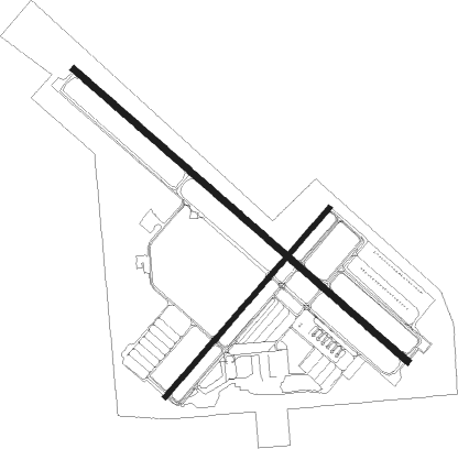
Runway info
Runway 12 / 30  | ||
| length | 2107m (6913ft) | |
| bearing | 131° / 311° | |
| width | 30m (100ft) | |
| surface | asphalt | |
| Runway 3 / 21 | ||
| length | 1188m (3898ft) | |
| bearing | 50° / 230° | |
| width | 23m (75ft) | |
| surface | asphalt | |
| displ threshold | 10m (33ft) / 0m (0ft) | |
| blast zone | 72m (236ft) / 0m (0ft) | |
Nearby beacons
| code | identifier | dist | bearing | frequency |
|---|---|---|---|---|
| AVQ | MARANA NDB | 0.1 | 51° | 245 |
| RYN | RYAN (TUCSON) NDB | 16.5 | 168° | 338 |
| RBJ | ROBLES (TUCSON) NDB | 21.3 | 203° | 220 |
| DMA | DAVIS-MONTHAN (TUCSON) TACAN | 22.7 | 126° | 117.60 |
| TUS | TUCSON VORTAC | 24.3 | 136° | 116 |
| TFD | STANFIELD (CASA GRANDE) VORTAC | 45.1 | 305° | 114.80 |
| IWA | WILLIE (PHOENIX) VORTAC | 57.9 | 334° | 113.30 |
| OLS | NOGALES VOR/DME | 62.6 | 160° | 108.20 |
| FHU | LIBBY (FT HUACHUCA) VOR/DME | 66 | 134° | 113.60 |
| ARH | FORT HUACHUCA TACAN | 66.7 | 133° | 111.60 |
Instrument approach procedures
| runway | airway (heading) | route (dist, bearing) |
|---|---|---|
| RW03 | ALMON (85°) | ALMON COXOT (9mi, 136°) 5400ft |
| RNAV | COXOT 5400ft WOTBI (5mi, 50°) 4300ft HIPEM (2mi, 50°) 3700ft KAVQ (5mi, 49°) 2054ft (6474mi, 106°) 2432ft ALMON (6488mi, 286°) 6000ft ALMON (turn) 6000ft | |
| RW12 | PICLI (134°) | PICLI CITUT (11mi, 96°) 4900ft SECBO (8mi, 181°) 3700ft |
| RNAV | SECBO 3700ft PAPBI (2mi, 181°) 3200ft ZIBAR (3mi, 146°) 2212ft (6474mi, 106°) 2420ft PICLI (6483mi, 286°) 6500ft PICLI (turn) | |
| RW21 | ALMON (85°) | ALMON PICLI (17mi, 3°) 6600ft NABPI (17mi, 92°) 4900ft |
| RNAV | NABPI 4900ft FIMTU (9mi, 183°) 4400ft DUYED (4mi, 215°) 3120ft ZOMAP (3mi, 215°) 2240ft (6473mi, 106°) 2340ft TUPBO (6479mi, 286°) ALMON (12mi, 292°) 6700ft ALMON (turn) | |
| RWNVE | TUS (316°) | TUS TACYU (8mi, 341°) 8200ft WULOV (6mi, 341°) 6700ft |
| RNAV | WULOV 6700ft TOSYU (6mi, 291°) 4900ft KAVQ (6mi, 292°) 2820ft (6474mi, 106°) 2820ft KULRE (6479mi, 286°) ALMON (9mi, 249°) 6000ft ALMON (turn) |
Disclaimer
The information on this website is not for real aviation. Use this data with the X-Plane flight simulator only! Data taken with kind consent from X-Plane 12 source code and data files. Content is subject to change without notice.