Waycross - Waycross Ware Co
Airport details
| Country | United States of America |
| State | Georgia |
| Region | K7 |
| Airspace | Jacksonville Ctr |
| Municipality | Ware County |
| Elevation | 142ft (43m) |
| Timezone | GMT -5 |
| Coordinates | 31.24839, -82.39539 |
| Magnetic var | |
| Type | land |
| Available since | X-Plane v10.40 |
| ICAO code | KAYS |
| IATA code | AYS |
| FAA code | AYS |
Communication
| Waycross Ware Co AWOS 3 | 118.575 |
| Waycross Ware Co CTAF/UNICOM | 122.800 |
Approach frequencies
| ILS-cat-I | RW19 | 108.3 | 18.00mi |
| 3° GS | RW19 | 108.3 | 18.00mi |
Nearby Points of Interest:
United States Post Office and Courthouse
-Downtown Waycross Historic District
-First African Baptist Church and Parsonage (Waycross, Georgia)
-Blackshear Depot
-Pierce County Courthouse
-Pierce County Jail
-Obediah Barber Homestead
-Bacon County Courthouse
-Rabinowitz Building
-Alma Depot
-Brantley County Courthouse
-Clinch County Courthouse
-Atkinson County Courthouse
-Eleventh District A & M School-South Georgia College Historic District
-Gaskin Avenue Historic District
-Downtown Douglas Historic District
-Union Banking Company Building
-Lonnie A. Pope House
-Ritch–Carter–Martin House
-Sylvester Mumford House
-Appling County Courthouse
-United States Post Office-Baxley, Georgia
-William Mizell, Sr., House
-C. W. Deen House
-Charlton County Courthouse
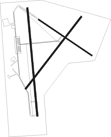
Runway info
Runway 1 / 19  | ||
| length | 1828m (5997ft) | |
| bearing | 359° / 179° | |
| width | 30m (100ft) | |
| surface | asphalt | |
| blast zone | 52m (171ft) / 46m (151ft) | |
| Runway 5 / 23 | ||
| length | 1539m (5049ft) | |
| bearing | 47° / 227° | |
| width | 30m (100ft) | |
| surface | asphalt | |
| Runway 13 / 31 | ||
| length | 1084m (3556ft) | |
| bearing | 124° / 304° | |
| width | 23m (75ft) | |
| surface | asphalt | |
Nearby beacons
| code | identifier | dist | bearing | frequency |
|---|---|---|---|---|
| AY | WIKET (WAYCROSS) NDB | 4.6 | 358° | 219 |
| AYS | WAYCROSS VORTAC | 8.3 | 277° | 110.20 |
| AMG | ALMA VORTAC | 18.2 | 339° | 115.10 |
| HOE | HOMERVILLE NDB | 22.5 | 243° | 209 |
| BHC | BAXLEY NDB | 27.8 | 1° | 376 |
| OWC | COFFEE COUNTY (DOUGLAS) NDB | 28.6 | 286° | 390 |
| AZE | HAZLEHURST NDB | 40 | 338° | 414 |
| VAD | MOODY (VALDOSTA) TACAN | 44.5 | 250° | 113.30 |
| TAY | TAYLOR VORTAC | 45.3 | 192° | 112.90 |
| SSI | BRUNSWICK (ST SIMONS I) VORTAC | 50.2 | 102° | 109.80 |
| SUR | FITZGERALD NDB | 50.8 | 292° | 362 |
| OTK | VALDOSTA VOR/DME | 53.4 | 242° | 114.80 |
| JA | DINNS (JACKSONVILLE) NDB | 56.1 | 143° | 344 |
| MQW | MC RAE NDB | 56.6 | 330° | 280 |
| MOQ | MC INTOSH (HINESVILLE) NDB | 57.2 | 57° | 263 |
| UQN | ONYUN (VIDALIA) NDB | 58.7 | 6° | 372 |
| EZM | EASTMAN NDB | 65.7 | 319° | 366 |
| CRG | CRAIG (JACKSONVILLE) VORTAC | 71.2 | 136° | 114.50 |
| NRB | MAYPORT TACAN | 71.9 | 131° | 111.40 |
Instrument approach procedures
| runway | airway (heading) | route (dist, bearing) |
|---|---|---|
| RW01 | AWNED (321°) | AWNED BAQAV (8mi, 269°) 1800ft |
| RW01 | BAQAV (360°) | BAQAV 1800ft |
| RW01 | WIWHE (39°) | WIWHE BAQAV (8mi, 89°) 1800ft |
| RNAV | BAQAV 1800ft AGMEQ (6mi, 359°) 1800ft KAYS (6mi, 1°) 189ft (5015mi, 111°) 412ft BIJUV (5016mi, 291°) 1700ft BIJUV (turn) | |
| RW19 | BIJUV (178°) | BIJUV 1700ft |
| RW19 | FEVAL (139°) | FEVAL BIJUV (8mi, 89°) 1700ft |
| RW19 | HULEG (219°) | HULEG BIJUV (8mi, 269°) 1700ft |
| RNAV | BIJUV 1700ft AGLUY (6mi, 179°) 1700ft SHOGI (3mi, 179°) 660ft KAYS (2mi, 174°) 190ft (5015mi, 111°) 340ft BAQAV (5014mi, 291°) 1800ft BAQAV (turn) |
Disclaimer
The information on this website is not for real aviation. Use this data with the X-Plane flight simulator only! Data taken with kind consent from X-Plane 12 source code and data files. Content is subject to change without notice.