Kalamazoo - Kalamazoo Battle Creek Intl
Airport details
| Country | United States of America |
| State | Michigan |
| Region | K5 |
| Airspace | Chicago Ctr |
| Municipality | Kalamazoo |
| Elevation | 874ft (266m) |
| Timezone | GMT -5 |
| Coordinates | 42.23439, -85.55155 |
| Magnetic var | |
| Type | land |
| Available since | X-Plane v10.40 |
| ICAO code | KAZO |
| IATA code | AZO |
| FAA code | AZO |
Communication
| Kalamazoo Battle Creek Intl ATIS | 127.250 |
| Kalamazoo Battle Creek Intl UNICOM | 122.950 |
| Kalamazoo Battle Creek Intl CTAF | 118.300 |
| Kalamazoo Battle Creek Intl Clearance DEL | 121.750 |
| Kalamazoo Battle Creek Intl Ground Control | 121.900 |
| Kalamazoo Battle Creek Intl Tower | 118.300 |
| Kalamazoo Battle Creek Intl Approach/Departure | 119.200 |
| Kalamazoo Battle Creek Intl Approach/Departure | 121.200 |
| Kalamazoo Battle Creek Intl Approach/Departure | 123.800 |
Approach frequencies
| ILS-cat-I | RW35 | 110.9 | 18.00mi |
| 3° GS | RW35 | 110.9 | 18.00mi |
Nearby Points of Interest:
Portage Street Fire Station
-Andrew J. Stevens House
-Rose Place Historic District
-William L. Welsh Terrace
-Vine Area Historic District
-Isaac Brown House
-State Hospital Gatehouse
-Kalamazoo State Hospital Water Tower
-Henry Montague House
-Ladies' Library Association Building
-Haymarket Historic District
-Desenberg Building
-East Campus
-South Street Historic District
-Lawrence and Chapin Building
-Engine House No. 3
-Masonic Temple Building
-Old Fire House No. 4
-Henderson Park-West Main Hill Historic District
-Booth-Dunham Estate
-The Acres
-Oshtemo Town Hall
-Fanckboner-Nichols Farmstead
-Richland Historic District
-Climax Post Office Building
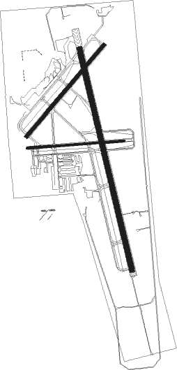
Runway info
Runway 17 / 35  | ||
| length | 1984m (6509ft) | |
| bearing | 168° / 348° | |
| width | 46m (150ft) | |
| surface | asphalt | |
| Runway 5 / 23 | ||
| length | 1048m (3438ft) | |
| bearing | 53° / 233° | |
| width | 30m (100ft) | |
| surface | asphalt | |
| Runway 9 / 27 | ||
| length | 851m (2792ft) | |
| bearing | 90° / 270° | |
| width | 18m (60ft) | |
| surface | asphalt | |
Nearby beacons
| code | identifier | dist | bearing | frequency |
|---|---|---|---|---|
| AZO | KALAMAZOO VOR/DME | 0.1 | 328° | 109 |
| AZ | AUSTN (KALAMAZOO) NDB | 6.2 | 168° | 371 |
| BT | BATOL (BATTLE CREEK) NDB | 18 | 71° | 272 |
| IRS | STURGIS NDB | 25.8 | 164° | 382 |
| ELX | KEELER VOR/DME | 25.9 | 261° | 116.60 |
| PMM | PULLMAN VOR/DME | 28.2 | 293° | 112.10 |
| VIO | VICTORY VOR/DME | 33.2 | 6° | 115.95 |
| LFD | LITCHFIELD VOR/DME | 36.5 | 102° | 111.20 |
| GR | KNOBS (GRAND RAPIDS) NDB | 40.4 | 15° | 263 |
| SB | MISHA (SOUTH BEND) NDB | 43.5 | 232° | 341 |
| GIJ | GIPPER (NILES) VORTAC | 44.2 | 239° | 115.40 |
| GSH | GOSHEN VORTAC | 47.6 | 214° | 113.70 |
| OLK | WEBSTER LAKE VOR | 59.3 | 177° | 110.40 |
| MKG | MUSKEGON TACAN | 60.1 | 332° | 115.20 |
| GW | SHENK (AUBURN) NDB | 61.9 | 147° | 227 |
Instrument approach procedures
| runway | airway (heading) | route (dist, bearing) |
|---|---|---|
| RW05 | ELX (81°) | ELX COLDT (17mi, 97°) 2700ft |
| RW05 | GIJ (59°) | GIJ COLDT (33mi, 60°) 2700ft |
| RW05 | VENTU (15°) | VENTU COLDT (13mi, 334°) 2700ft |
| RW05 | WHOOF (148°) | WHOOF COLDT (12mi, 234°) 2700ft COLDT (turn) 2700ft |
| RNAV | COLDT 2700ft FOSDO (6mi, 53°) 2500ft MATEY (3mi, 53°) 1520ft KAZO (2mi, 59°) 902ft (5207mi, 116°) 1274ft AMPEY (5200mi, 296°) 3000ft AMPEY (turn) | |
| RW17 | AZO (148°) | AZO OSEGO (13mi, 349°) 3000ft OSEGO (turn) 3000ft |
| RW17 | BOHRR (198°) | BOHRR OSEGO (11mi, 231°) 3000ft |
| RW17 | PMM (113°) | PMM OSEGO (22mi, 91°) 3000ft |
| RNAV | OSEGO 3000ft SUYOD (7mi, 168°) 2800ft WURAX (4mi, 168°) 1460ft KAZO (2mi, 170°) 904ft (5207mi, 116°) 1148ft COVAV (5205mi, 296°) 2800ft COVAV (turn) | |
| RW23 | BOHRR (198°) | BOHRR AMPEY (13mi, 163°) 3000ft |
| RW23 | HEBEL (221°) | HEBEL AMPEY (5mi, 186°) 3000ft |
| RW23 | WHOOF (148°) | WHOOF AMPEY (12mi, 53°) 3000ft AMPEY (turn) 3000ft |
| RNAV | AMPEY 3000ft BEDJO (7mi, 233°) 2500ft YUKUK (3mi, 233°) 1520ft KAZO (2mi, 227°) 889ft (5207mi, 116°) 1220ft COLDT (5215mi, 296°) 2700ft COLDT (turn) | |
| RW35 | WHOOF (148°) | WHOOF COVAV (13mi, 168°) 2800ft COVAV (turn) 2800ft |
| RW35 | YURUD (346°) | YURUD COVAV (6mi, 341°) 2800ft |
| RNAV | COVAV 2800ft EYOLU (6mi, 348°) 2800ft GLEEK (3mi, 348°) 1780ft KAZO (3mi, 347°) 921ft (5207mi, 116°) 1068ft OSEGO (5210mi, 296°) 3000ft OSEGO (turn) |
Disclaimer
The information on this website is not for real aviation. Use this data with the X-Plane flight simulator only! Data taken with kind consent from X-Plane 12 source code and data files. Content is subject to change without notice.