Bad Axe - Huron Co Mem
Airport details
| Country | United States of America |
| State | Michigan |
| Region | K5 |
| Airspace | Cleveland Ctr |
| Municipality | Verona Township |
| Elevation | 763ft (233m) |
| Timezone | GMT -5 |
| Coordinates | 43.78022, -82.98542 |
| Magnetic var | |
| Type | land |
| Available since | X-Plane v10.40 |
| ICAO code | KBAX |
| IATA code | n/a |
| FAA code | BAX |
Communication
| Huron Co Mem AWOS | 118.600 |
| Huron Co Mem CTAF/UNICOM | 122.975 |
Nearby Points of Interest:
Albert E. Sleeper House
-Sanilac Petroglyphs Historic State Park
-First Presbyterian Church
-Frank Murphy Birthplace
-St. John's Lutheran Church
-First Methodist Episcopal Church
-Grice House Museum
-William R. Stafford House
-Frederick H. and Elizabeth Stafford House
-Masonic Temple
-Herman House
-Melligan Store-Agriculture Hall
-W. R. Stafford Saw Mill
-Charles G. Learned House
-Winsor and Snover Bank Building
-Grindstone City Historic District
-Indian Mission
-Tuscola County Courthouse
-Trinity Episcopal Church
-Port Sanilac Masonic and Town Hall
-Loop-Harrison Mansion
Runway info
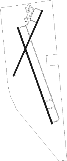
Runway 4 / 22  | ||
| length | 1065m (3494ft) | |
| bearing | 37° / 217° | |
| width | 23m (75ft) | |
| surface | asphalt | |
| displ threshold | 93m (305ft) / 0m (0ft) | |
| Runway 17 / 35 | ||
| length | 1528m (5013ft) | |
| bearing | 159° / 339° | |
| width | 23m (75ft) | |
| surface | asphalt | |
| blast zone | 43m (141ft) / 46m (151ft) | |
Nearby beacons
| code | identifier | dist | bearing | frequency |
|---|---|---|---|---|
| ECK | PECK TACAN | 33.5 | 153° | 114 |
| ASP | SABLE (OSCODA) DME | 43.8 | 329° | 116.10 |
| PH | PHURN (PORT HURON) NDB | 58.7 | 157° | 332 |
| FNT | FLINT VORTAC | 59 | 223° | 116.90 |
Instrument approach procedures
| runway | airway (heading) | route (dist, bearing) |
|---|---|---|
| RW04 | BUPBA (7°) | BUPBA CASKU (5mi, 291°) 3000ft |
| RW04 | MBS (77°) | MBS CASKU (42mi, 85°) 3000ft CASKU (turn) 3000ft |
| RW04 | WHOOP (122°) | WHOOP AYALI (47mi, 137°) 3000ft CASKU (5mi, 111°) 3000ft |
| RNAV | CASKU 3000ft DUDAC (6mi, 37°) 2500ft KBAX (5mi, 38°) 795ft (5101mi, 118°) 1140ft IDICE (5097mi, 298°) 3000ft IDICE (turn) | |
| RW17 | ANIVE (202°) | ANIVE ELARE (7mi, 259°) 3000ft |
| RW17 | ELARE (159°) | ELARE 3000ft |
| RW17 | MBS (77°) | MBS BAYAC (47mi, 66°) 3000ft ELARE (5mi, 79°) 3000ft |
| RW17 | WHOOP (122°) | WHOOP BAYAC (36mi, 119°) 3000ft ELARE (5mi, 79°) 3000ft |
| RNAV | ELARE 3000ft CAMOG (6mi, 159°) 2400ft KBAX (5mi, 159°) 803ft (5101mi, 118°) 1075ft AREBE (5097mi, 298°) 3000ft AREBE (turn) | |
| RW22 | HALNA (240°) | HALNA IDICE (5mi, 291°) 4000ft IDICE (turn) 3000ft |
| RW22 | MBS (77°) | MBS IDICE (59mi, 71°) 3000ft IDICE (turn) 3000ft |
| RW22 | WHOOP (122°) | WHOOP GUCET (42mi, 110°) 3000ft IDICE (5mi, 111°) 3000ft |
| RNAV | IDICE 3000ft JANIK (6mi, 217°) 2500ft KEVEC (3mi, 217°) 1440ft KBAX (2mi, 214°) 812ft (5101mi, 118°) 1140ft CASKU (5106mi, 298°) 3000ft CASKU (turn) | |
| RW35 | AREBE (340°) | AREBE 3000ft |
| RW35 | MBS (77°) | MBS DODKE (46mi, 89°) 3000ft AREBE (5mi, 79°) 3000ft |
| RNAV | AREBE 3000ft BACAD (7mi, 340°) 2400ft CALTA (2mi, 339°) 1780ft KBAX (4mi, 340°) 793ft (5101mi, 118°) 1113ft ELARE (5105mi, 298°) 3000ft ELARE (turn) |
Disclaimer
The information on this website is not for real aviation. Use this data with the X-Plane flight simulator only! Data taken with kind consent from X-Plane 12 source code and data files. Content is subject to change without notice.