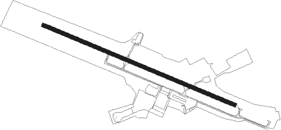
Blacksburg - Virginia Tech Montgomery Exec
Airport details
| Country | United States of America |
| State | Virginia |
| Region | K6 |
| Airspace | Washington Ctr |
| Municipality | Blacksburg |
| Elevation | 2129ft (649m) |
| Timezone | GMT -5 |
| Coordinates | 37.20764, -80.40784 |
| Magnetic var | |
| Type | land |
| Available since | X-Plane v10.40 |
| ICAO code | KBCB |
| IATA code | BCB |
| FAA code | BCB |
Communication
| Virginia Tech Montgomery Exec AWOS 3 | 133.325 |
| Virginia Tech Montgomery Exec CTAF/UNICOM | 123.050 |
| Virginia Tech Montgomery Exec ROANOKE Approach/Departure | 126.900 |
Approach frequencies
| LOC | RW13 | 109.1 | 18.00mi |
Nearby Points of Interest:
Amiss-Palmer House
-Currie House
-Phillips-Ronald House
-Blacksburg Motor Company, Inc.
-Smithfield
-Solitude (Blacksburg, Virginia)
-Blacksburg Historic District
-Odd Fellows Hall
-Keister House
-Whitethorn (Blacksburg, Virginia)
-Earhart House
-Virginian Railway Underpass
-George Earhart House
-Linkous-Kipps House
-Blankenship Farm
-Adam Wall House
-Michael Kinzer House
-Joseph McDonald Farm
-Evans House No. 2
-Edgar A. Long Building
-Cambria Freight Station
-Old Christiansburg Industrial Institute
-Walnut Spring
-Surface House
-The Oaks (Christiansburg, Virginia)
Nearby beacons
| code | identifier | dist | bearing | frequency |
|---|---|---|---|---|
| TEC | TECH (BLACKSBURG) NDB | 0.2 | 78° | 368 |
| PSK | PULASKI (DUBLIN) VORTAC | 16.2 | 249° | 116.80 |
| ROA | ROANOKE VOR/DME | 18 | 68° | 109.40 |
| ODR | WOODRUM (ROANOKE) VOR | 21.6 | 75° | 114.90 |
| VIT | VINTON (ROANOKE) NDB | 25.1 | 90° | 277 |
| LW | BUSHI (LEWISBURG) NDB | 34.6 | 354° | 346 |
| BLF | BLUEFIELD VOR/DME | 38 | 277° | 110 |
| LWB | DME | 39.4 | 1° | 116.05 |
| UV | BALES (MARTINSVILLE) NDB | 43.9 | 142° | 396 |
| BKW | BECKLEY VOR/DME | 48.4 | 309° | 117.70 |
| RNL | RAINELLE VOR | 49.8 | 333° | 116.60 |
| SIF | SLAMMER (REIDSVILLE) NDB | 58.5 | 142° | 423 |
| JUH | ASHEE (JEFFERSON) NDB | 63.9 | 230° | 410 |
Departure and arrival routes
| Transition altitude | 18000ft |
| Transition level | 18000ft |
| SID end points | distance | outbound heading | |
|---|---|---|---|
| RW13 | |||
| BEMAR3 | 59mi | 225° | |
| RW31 | |||
| SETHY5 | 20mi | 114° | |
Instrument approach procedures
| runway | airway (heading) | route (dist, bearing) |
|---|---|---|
| RW13 | OBERS (106°) | OBERS HAWTO (16mi, 100°) 5700ft |
| RW13 | WILIZ (22°) | WILIZ HAWTO (26mi, 346°) 5700ft HAWTO (turn) 5700ft |
| RNAV | HAWTO 5700ft SUNNY (7mi, 112°) 4200ft ZUPAT (2mi, 112°) 3380ft KBCB (4mi, 112°) 2174ft (4947mi, 115°) 2389ft ZASNO (4935mi, 295°) 5400ft ZASNO (turn) 5400ft | |
| RW31 | TABER (294°) | TABER ZASNO (6mi, 297°) 5400ft |
| RW31 | WILIZ (22°) | WILIZ KINIW (12mi, 59°) 5700ft ZASNO (12mi, 59°) 5400ft ZASNO (turn) 5400ft |
| RNAV | ZASNO 5400ft OSMSS (4mi, 292°) 4900ft CABID (3mi, 292°) 4200ft KBCB (7mi, 292°) 2170ft (4947mi, 115°) 2412ft HAWTO (4959mi, 295°) 5900ft HAWTO (turn) 5900ft |
Disclaimer
The information on this website is not for real aviation. Use this data with the X-Plane flight simulator only! Data taken with kind consent from X-Plane 12 source code and data files. Content is subject to change without notice.
