Boulder - Boulder Muni
Airport details
| Country | United States of America |
| State | Colorado |
| Region | K2 |
| Airspace | Denver Ctr |
| Municipality | Boulder |
| Elevation | 5288ft (1612m) |
| Timezone | GMT -7 |
| Coordinates | 40.03937, -105.22609 |
| Magnetic var | |
| Type | land |
| Available since | X-Plane v10.40 |
| ICAO code | KBDU |
| IATA code | WBU |
| FAA code | BDU |
Communication
| Boulder Muni AWOS 3 | 118.825 |
| Boulder Muni CTAF/UNICOM | 122.725 |
Nearby Points of Interest:
McKenzie Well
-Boulder County Poor Farm
-Carnegie Library
-Boulder Valley Grange No. 131
-Little Church in the Pines
-Salina School
-Walker Ranch
-Wall Street Assay Office
-Rocky Flats Plant
-Longmont Fire Department
-St. Stephen's Episcopal Church
-Longmont College
-Ward Congregational Church
-William J. Gregory House
-Thede Farmhouse
-Bowles House
-Harris Park School
-Arvada Downtown
-United Church of Christ of Highlandlake
-Arvada Flour Mill
-Pioneer Sod House
-Eldora Historic District
-Golden High School
-Barnes–Peery House
-Loveland Block and Coors Building
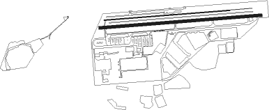
Runway info
Runway 8 / 26  | ||
| length | 1307m (4288ft) | |
| bearing | 90° / 270° | |
| width | 23m (75ft) | |
| surface | asphalt | |
| displ threshold | 93m (305ft) / 31m (102ft) | |
| Runway 8L / 26R | ||
| length | 1018m (3340ft) | |
| bearing | 90° / 270° | |
| width | 6m (20ft) | |
| surface | asphalt | |
Nearby beacons
| code | identifier | dist | bearing | frequency |
|---|---|---|---|---|
| BJC | JEFFCO (DENVER) VOR/DME | 8.5 | 145° | 115.40 |
| FN | COLLN (FT COLLINS-LOVELAND) NDB | 22.6 | 38° | 400 |
| DVV | MILE HIGH (DENVER) VORTAC | 29 | 104° | 114.70 |
| DEN | DENVER VOR/DME | 29.3 | 112° | 117.90 |
| BKF | BUCKLEY (AURORA) TACAN | 29.5 | 125° | 109.60 |
| FQF | FALCON (DENVER) VORTAC | 34.8 | 120° | 116.30 |
| GLL | GILL VOR/DME | 41.5 | 55° | 114.20 |
Disclaimer
The information on this website is not for real aviation. Use this data with the X-Plane flight simulator only! Data taken with kind consent from X-Plane 12 source code and data files. Content is subject to change without notice.