Birmingham - Birmingham–shuttlesworth Intl
Airport details
| Country | United States of America |
| State | Alabama |
| Region | K7 |
| Airspace | Atlanta Ctr |
| Municipality | Birmingham |
| Elevation | 643ft (196m) |
| Timezone | GMT -6 |
| Coordinates | 33.57044, -86.74911 |
| Magnetic var | |
| Type | land |
| Available since | X-Plane v10.40 |
| ICAO code | KBHM |
| IATA code | BHM |
| FAA code | BHM |
Communication
| Birmingham–Shuttlesworth Intl ANNISTON FSS | 122.200 |
| Birmingham–Shuttlesworth Intl ANNISTON FSS | 123.650 |
| Birmingham–Shuttlesworth Intl KBHM ATIS | 119.400 |
| Birmingham–Shuttlesworth Intl BIRMINGHAM_INTL UNIC | 122.950 |
| Birmingham–Shuttlesworth Intl BIRMINGHAM CLD | 125.675 |
| Birmingham–Shuttlesworth Intl BIRMINGHAM Ground Control | 121.700 |
| Birmingham–Shuttlesworth Intl BIRMINGHAM Tower | 119.900 |
| Birmingham–Shuttlesworth Intl BIRMINGHAM Approach | 123.800 |
| Birmingham–Shuttlesworth Intl BIRMINGHAM Approach | 127.675 |
| Birmingham–Shuttlesworth Intl BIRMINGHAM Departure | 123.800 |
| Birmingham–Shuttlesworth Intl BIRMINGHAM Departure | 127.675 |
Approach frequencies
| LOC | RW18 | 111.3 | 18.00mi |
| ILS-cat-II | RW06 | 110.3 | 18.00mi |
| ILS-cat-II | RW24 | 109.5 | 18.00mi |
| 3° GS | RW06 | 110.3 | 18.00mi |
| 3° GS | RW24 | 109.5 | 18.00mi |
Nearby Points of Interest:
Fire Station No. 12
-Woodlawn
-Fire Station No. 10
-East End Baptist Church
-Jefferson County Courthouse
-Downtown Birmingham Historic District
-Whilldin Building
-First United Methodist Church
-Watts Building
-John Hand Building
-Federal Reserve Bank of Atlanta Birmingham Branch
-Heaviest Corner on Earth
-Robert S. Vance Federal Building and United States Courthouse
-Downtown Birmingham Retail and Theatre Historic District
-Fire Station No. 3
-Fire Station No. 11
-Birmingham Civil Rights District
-Fire Station No. 6
-Red Mountain Expressway Cut
-John D. and Katherine Gleissner Lustron House
-Bernice L. Wright Lustron House
-Second Presbyterian Church
-Dr. A.M. Brown House
-Belview Heights Historic District
-Flintridge Building
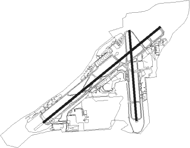
Runway info
Runway 6 / 24  | ||
| length | 3656m (11995ft) | |
| bearing | 60° / 240° | |
| width | 46m (151ft) | |
| surface | asphalt | |
| displ threshold | 0m (0ft) / 365m (1198ft) | |
| blast zone | 60m (197ft) / 122m (400ft) | |
| Runway 18 / 36 | ||
| length | 2171m (7123ft) | |
| bearing | 180° / 0° | |
| width | 46m (151ft) | |
| surface | asphalt | |
| blast zone | 0m (0ft) / 60m (197ft) | |
Nearby beacons
| code | identifier | dist | bearing | frequency |
|---|---|---|---|---|
| BH | MCDEN (BIRMINGHAM) NDB | 5.9 | 239° | 224 |
| VUZ | VULCAN (BIRMINGHAM) VORTAC | 9.6 | 303° | 114.40 |
| OKW | BROOKWOOD VORTAC | 32 | 236° | 111 |
| TDG | DME | 35.3 | 90° | 108.80 |
| AN | BOGGA (ANNISTON) NDB | 40.9 | 93° | 211 |
| GAD | GADSDEN VOR/DME | 41.2 | 59° | 112.30 |
| LDK | CRIMSON VORTAC | 43.7 | 248° | 117.80 |
| TC | TUSKE (TUSCALOOSA) NDB | 52.4 | 246° | 362 |
Instrument approach procedures
| runway | airway (heading) | route (dist, bearing) |
|---|---|---|
| RW06-Y | HEENA (19°) | HEENA GUFLO (14mi, 327°) 3000ft CEMPO (6mi, 60°) 2600ft |
| RW06-Y | OKW (56°) | OKW GUFLO (16mi, 53°) 3000ft CEMPO (6mi, 60°) 2600ft |
| RW06-Y | RIMZO (85°) | RIMZO GUFLO (9mi, 140°) 3000ft CEMPO (6mi, 60°) 2600ft |
| RNAV | CEMPO 2600ft JUSGO (4mi, 60°) 2200ft KBHM (6mi, 59°) 656ft SPATT (12mi, 61°) 3300ft SPATT (turn) | |
| RW06-Z | CRMSN (68°) | CRMSN JAVJA (7mi, 62°) 9000ft WOSIX (12mi, 77°) 6000ft GUFLO (9mi, 77°) 4000ft LELNE (9mi, 60°) 2300ft |
| RW06-Z | KYLEE (317°) | KYLEE HIPIX (13mi, 300°) 6000ft BAMTE (12mi, 301°) 4000ft RAVPE (4mi, 291°) 3000ft LELNE (5mi, 354°) 2300ft |
| RW06-Z | VLKNN (124°) | VLKNN AYUCE (5mi, 195°) 3000ft CEWFA (3mi, 196°) 2300ft LELNE (5mi, 120°) 2300ft |
| RW06-Z | WENDO (239°) | WENDO MREKK (10mi, 238°) 6000ft EMIZI (20mi, 253°) 4000ft AYUCE (6mi, 248°) 3000ft CEWFA (3mi, 196°) 2300ft LELNE (5mi, 120°) 2300ft |
| RNAV | LELNE 2300ft KBHM (7mi, 59°) 657ft KEGTE (3mi, 62°) CILAL (9mi, 323°) VLKNN (7mi, 244°) 3000ft VLKNN (turn) | |
| RW18 | ALEPE (210°) | ALEPE COLIG (6mi, 270°) 3500ft |
| RW18 | CAPUN (144°) | CAPUN COLIG (8mi, 90°) 3500ft |
| RW18 | COLIG (181°) | COLIG 3500ft |
| RNAV | COLIG 3500ft BIDPE (4mi, 180°) 2600ft BASKN (4mi, 180°) 2300ft IMTOY (3mi, 180°) 1380ft KBHM (2mi, 183°) 695ft (5243mi, 111°) 1050ft HAMGA (5242mi, 291°) HANDE (17mi, 133°) 3800ft HANDE (turn) | |
| RW24-Y | VUZ (123°) | VUZ SPATT (18mi, 87°) 3600ft SPATT (turn) 3300ft |
| RNAV | SPATT 3300ft HUKEV (4mi, 240°) 2700ft LOWGA (3mi, 240°) 2200ft CUXOB (1mi, 240°) 1740ft KBHM (4mi, 242°) 692ft (5243mi, 111°) 1300ft CAPUN (5251mi, 291°) 3000ft CAPUN (turn) | |
| RW24-Z | CRMSN (68°) | CRMSN JAVJA (7mi, 62°) 9000ft ISOJO (12mi, 63°) 6000ft HESGA (19mi, 62°) 4000ft MOPVE (8mi, 51°) 3000ft ERIGE (4mi, 83°) 2500ft LOWGA (5mi, 155°) 2200ft |
| RW24-Z | KYLEE (317°) | KYLEE WEDEB (12mi, 330°) 6000ft MOKEE (12mi, 330°) 3600ft NOCIM (4mi, 347°) 2400ft LOWGA (4mi, 289°) 2200ft |
| RW24-Z | VLKNN (124°) | VLKNN MOPVE (6mi, 83°) 3000ft ERIGE (4mi, 83°) 2500ft LOWGA (5mi, 155°) 2200ft |
| RW24-Z | WENDO (239°) | WENDO MREKK (10mi, 238°) 6000ft SPATT (7mi, 238°) 4000ft HUKEV (4mi, 240°) 2700ft LOWGA (3mi, 240°) 2200ft |
| RNAV | LOWGA 2200ft KBHM (5mi, 241°) 692ft YACUR (8mi, 239°) WADEG (10mi, 325°) VLKNN (4mi, 68°) 3000ft VLKNN (turn) | |
| RW36 | GOTBY (359°) | GOTBY 3000ft |
| RW36 | OKW (56°) | OKW JAPAM (19mi, 84°) 3000ft GOTBY (7mi, 84°) 3000ft |
| RNAV | GOTBY 3000ft IMOBY (7mi, 360°) 2800ft BERFY (4mi, 360°) 2300ft KBHM (6mi, 359°) 684ft (5243mi, 111°) 1050ft BASKN (5243mi, 291°) VUZ (8mi, 277°) 3000ft VUZ (turn) |
Disclaimer
The information on this website is not for real aviation. Use this data with the X-Plane flight simulator only! Data taken with kind consent from X-Plane 12 source code and data files. Content is subject to change without notice.