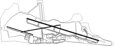
Billings - Billings Logan Intl
Airport details
| Country | United States of America |
| State | Montana |
| Region | K1 |
| Airspace | Salt Lake City Ctr |
| Municipality | Billings |
| Elevation | 3650ft (1113m) |
| Timezone | GMT -7 |
| Coordinates | 45.80766, -108.54288 |
| Magnetic var | |
| Type | land |
| Available since | X-Plane v10.40 |
| ICAO code | KBIL |
| IATA code | BIL |
| FAA code | BIL |
Communication
| Billings Logan Intl atis | 126.300 |
| Billings Logan Intl Ground Control CLR | 121.900 |
| Billings Logan Intl tower | 127.200 |
| Billings Logan Intl Departure | 120.500 |
Approach frequencies
| ILS-cat-I | RW10L | 111.5 | 18.00mi |
| ILS-cat-I | RW28R | 111.5 | 18.00mi |
| 3° GS | RW10L | 111.5 | 18.00mi |
| 3° GS | RW28R | 111.5 | 18.00mi |
Nearby Points of Interest:
Masonic Temple
-Billings Chamber of Commerce Building
-United States Post Office and Courthouse–Billings
-Oliver Building
-L and L Building
-Fire House No. 2
-Pictograph Cave
-Joliet Bridge
Runway info
Nearby beacons
| code | identifier | dist | bearing | frequency |
|---|---|---|---|---|
| BIL | BILLINGS VORTAC | 3.4 | 271° | 114.50 |
| HCY | COWLEY NDB | 53.8 | 174° | 257 |
| POY | POWELL NDB | 57.4 | 195° | 344 |
Departure and arrival routes
| Transition altitude | 18000ft |
| Transition level | 18000ft |
| STAR starting points | distance | inbound heading | |
|---|---|---|---|
| RW10L | |||
| YLSTN3 | 24.8 | 49° | |
| CRAZI3 | 54.9 | 108° | |
| KUSTR3 | 23.1 | 255° | |
| BGHRN3 | 21.6 | 308° | |
| RW28R | |||
| YLSTN3 | 24.8 | 49° | |
| CRAZI3 | 54.9 | 108° | |
| KUSTR3 | 23.1 | 255° | |
| BGHRN3 | 21.6 | 308° | |
Instrument approach procedures
| runway | airway (heading) | route (dist, bearing) |
|---|---|---|
| RW07 | BIL (91°) | BIL YURUB (8mi, 264°) 6000ft YURUB (turn) 6000ft |
| RW07 | COLUS (88°) | COLUS YURUB (12mi, 89°) 6000ft |
| RW07 | HAKDI (48°) | HAKDI YURUB (22mi, 21°) 6000ft |
| RW07 | WIBMU (108°) | WIBMU YURUB (9mi, 149°) 6000ft |
| RNAV | YURUB 6000ft CAPTU (6mi, 86°) 5300ft TOLNE (3mi, 86°) 4340ft KBIL (3mi, 87°) 3681ft (6174mi, 113°) 3886ft MUMEE (6163mi, 293°) 6000ft MUMEE (turn) | |
| RW10L | BEARE (97°) | BEARE 8000ft WIBON (6mi, 79°) 6000ft |
| RW10L | LRSUN (108°) | LRSUN 8000ft WIBON (7mi, 113°) 6000ft |
| RNAV | WIBON 6000ft HEXOS (6mi, 105°) 5300ft ZOBUM (3mi, 106°) 4360ft KBIL (3mi, 107°) 3635ft (6174mi, 113°) 3785ft POXRI (6169mi, 293°) KOXMY (9mi, 48°) 6000ft KOXMY (turn) | |
| RW25 | BIL (91°) | BIL MUMEE (15mi, 87°) 6000ft MUMEE (turn) 6000ft |
| RW25 | NIBBE (255°) | NIBBE MUMEE (11mi, 244°) 6000ft |
| RW25 | SEXPE (292°) | SEXPE MUMEE (17mi, 312°) 6000ft |
| RNAV | MUMEE 6000ft FASOK (6mi, 266°) 5200ft KBIL (5mi, 265°) 3570ft (6174mi, 113°) 3836ft OLOLE (6179mi, 293°) OXIVY (7mi, 300°) 6000ft OXIVY (turn) | |
| RW28RY | GRYZZ (318°) | GRYZZ 9000ft DOPIC (4mi, 63°) 7600ft YIGUD (5mi, 337°) 6000ft |
| RW28RY | HRDIN (293°) | HRDIN 6700ft YIGUD (5mi, 308°) 6000ft |
| RW28RY | KRONA (308°) | KRONA YIGUD (10mi, 335°) 6000ft |
| RW28RY | PILLR (278°) | PILLR 6300ft YIGUD (5mi, 266°) 6000ft |
| RNAV | YIGUD 6000ft PICTO (3mi, 286°) 5000ft YICUN (2mi, 286°) 4260ft KBIL (3mi, 284°) 3544ft (6174mi, 113°) 3767ft WIBON (6184mi, 293°) 5900ft WIBON (turn) | |
| RW28RZ | BBCAT (237°) | BBCAT 8000ft CUBEK (3mi, 105°) 7400ft PICTO (6mi, 210°) 5000ft |
| RW28RZ | GRYZZ (318°) | GRYZZ 9000ft DOPIC (4mi, 63°) 7600ft YIGUD (5mi, 337°) 6000ft PICTO (3mi, 286°) 5000ft |
| RW28RZ | HRDIN (293°) | HRDIN 6700ft YIGUD (5mi, 308°) 6000ft PICTO (3mi, 286°) 5000ft |
| RW28RZ | PILLR (278°) | PILLR 6300ft YIGUD (5mi, 266°) 6000ft PICTO (3mi, 286°) 5000ft |
| RNAV | PICTO 5000ft KBIL (6mi, 285°) 3544ft WIBON (12mi, 286°) 5900ft WIBON (turn) |
Holding patterns
| STAR name | hold at | type | turn | heading* | altitude | leg | speed limit |
|---|---|---|---|---|---|---|---|
| BGHRN3 | BGHRN | VHF | right | 131 (311)° | DME 10.0mi | ICAO rules | |
| CRAZI3 | CRAZI | VHF | right | 278 (98)° | DME 10.0mi | ICAO rules | |
| KUSTR3 | FSYTH | VHF | right | 63 (243)° | DME 10.0mi | ICAO rules | |
| YLSTN3 | YLSTN | VHF | right | 197 (17)° | DME 10.0mi | ICAO rules | |
| *) magnetic outbound (inbound) holding course | |||||||
Disclaimer
The information on this website is not for real aviation. Use this data with the X-Plane flight simulator only! Data taken with kind consent from X-Plane 12 source code and data files. Content is subject to change without notice.

