Baker City - Baker City Muni
Airport details
| Country | United States of America |
| State | Oregon |
| Region | K1 |
| Airspace | Salt Lake City Ctr |
| Municipality | Baker County |
| Elevation | 3373ft (1028m) |
| Timezone | GMT -8 |
| Coordinates | 44.83733, -117.80914 |
| Magnetic var | |
| Type | land |
| Available since | X-Plane v10.40 |
| ICAO code | KBKE |
| IATA code | BKE |
| FAA code | BKE |
Communication
| Baker City Muni ASOS | 134.275 |
| Baker City Muni CTAF/UNICOM | 123.000 |
Nearby Points of Interest:
Baker Historic District
-Superintendent's House
-Union Main Street Historic District
-Abel E. Eaton House
-Antlers Guard Station
-Ascension Episcopal Church
-Cornucopia Jailhouse
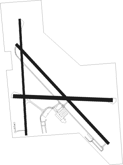
Runway info
Runway 13 / 31  | ||
| length | 1551m (5089ft) | |
| bearing | 132° / 312° | |
| width | 30m (100ft) | |
| surface | asphalt | |
| blast zone | 174m (571ft) / 0m (0ft) | |
| Runway 17 / 35 | ||
| length | 1330m (4364ft) | |
| bearing | 182° / 2° | |
| width | 23m (75ft) | |
| surface | asphalt | |
| displ threshold | 0m (0ft) / 121m (397ft) | |
| Runway 8 / 26 | ||
| length | 1115m (3658ft) | |
| bearing | 95° / 275° | |
| width | 43m (140ft) | |
| surface | asphalt | |
Nearby beacons
| code | identifier | dist | bearing | frequency |
|---|---|---|---|---|
| BKE | BAKER CITY VOR/DME | 0.2 | 21° | 115.30 |
| LGD | LA GRANDE NDB | 31 | 343° | 296 |
Instrument approach procedures
| runway | airway (heading) | route (dist, bearing) |
|---|---|---|
| RW13 | JELTI (106°) | JELTI SITOC (12mi, 68°) 8800ft |
| RW13 | LACED (128°) | LACED SITOC (17mi, 123°) 8800ft |
| RW13 | WOLIP (159°) | WOLIP SITOC (11mi, 223°) 8800ft |
| RNAV | SITOC 8800ft TEGTE (7mi, 132°) 7100ft ZASKA (5mi, 132°) 5800ft SOKNE (4mi, 132°) 4420ft KBKE (4mi, 132°) 3421ft (6565mi, 111°) 3800ft CAKPU (6557mi, 291°) 11000ft GOYEK (10mi, 76°) GOYEK (turn) |
Disclaimer
The information on this website is not for real aviation. Use this data with the X-Plane flight simulator only! Data taken with kind consent from X-Plane 12 source code and data files. Content is subject to change without notice.