Battle Creek - W K Kellogg
Airport details
| Country | United States of America |
| State | Michigan |
| Region | K5 |
| Airspace | Chicago Ctr |
| Municipality | Battle Creek |
| Elevation | 952ft (290m) |
| Timezone | GMT -5 |
| Coordinates | 42.30647, -85.25009 |
| Magnetic var | |
| Type | land |
| Available since | X-Plane v10.40 |
| ICAO code | KBTL |
| IATA code | BTL |
| FAA code | BTL |
Communication
| W K Kellogg ATIS | 128.325 |
| W K Kellogg CTAF | 118.500 |
| W K Kellogg UNICOM | 122.950 |
| W K Kellogg Ground Control | 121.700 |
| W K Kellogg BATTLE CREEK Tower | 126.825 |
| W K Kellogg KALAMAZOO Approach/Departure | 119.200 |
Approach frequencies
| ILS-cat-I | RW23R | 110.5 | 18.00mi |
| 2.9° GS | RW23R | 110.5 | 18.00mi |
Nearby Points of Interest:
Frank and Dorothy Ward House
-Roosevelt American Legion Hospital
-Advent Historic District
-Michigan Central Railroad Depot
-Record Printing and Box Company Building
-Battle Creek Sanitarium
-Battle Creek Tower
-City Hall Historic District
-Battle Creek City Hall
-Penniman Castle
-Merritt Woods Historic District
-Richard and Mary Woodward Gregory House
-Climax Post Office Building
-The Acres
-Richland Historic District
-Isaac Lockwood House
-Stonehall (Marshall, Michigan)
-Harold C. Brooks House
-Marshall Historic District
-William Prindle Livery Stable
-Masonic Temple Building
-Governor's Mansion
-Capitol Hill School
-Engine House No. 3
-Portage Street Fire Station
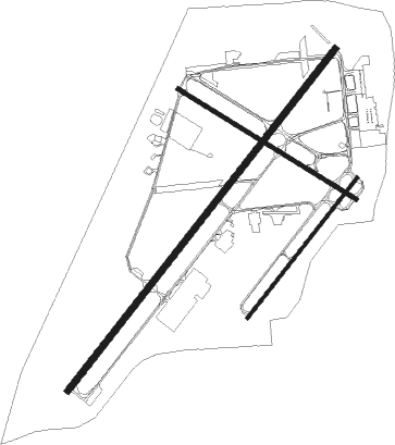
Runway info
Runway 5L / 23R  | ||
| length | 3047m (9997ft) | |
| bearing | 51° / 231° | |
| width | 46m (150ft) | |
| surface | asphalt | |
| blast zone | 61m (200ft) / 61m (200ft) | |
| Runway 5R / 23L | ||
| length | 1249m (4098ft) | |
| bearing | 51° / 231° | |
| width | 23m (75ft) | |
| surface | asphalt | |
| Runway 13 / 31 | ||
| length | 1472m (4829ft) | |
| bearing | 118° / 298° | |
| width | 30m (100ft) | |
| surface | asphalt | |
Nearby beacons
| code | identifier | dist | bearing | frequency |
|---|---|---|---|---|
| BT | BATOL (BATTLE CREEK) NDB | 4.4 | 50° | 272 |
| AZO | KALAMAZOO VOR/DME | 14 | 257° | 109 |
| AZ | AUSTN (KALAMAZOO) NDB | 16.2 | 238° | 371 |
| LFD | LITCHFIELD VOR/DME | 26 | 117° | 111.20 |
| IRS | STURGIS NDB | 30.7 | 200° | 382 |
| VIO | VICTORY VOR/DME | 30.8 | 333° | 115.95 |
| JXN | DME | 35.2 | 93° | 115.45 |
| GR | KNOBS (GRAND RAPIDS) NDB | 35.8 | 348° | 263 |
| PMM | PULLMAN VOR/DME | 39.1 | 281° | 112.10 |
| ELX | KEELER VOR/DME | 40 | 259° | 116.60 |
| SB | MISHA (SOUTH BEND) NDB | 56.3 | 238° | 341 |
| GSH | GOSHEN VORTAC | 58.3 | 225° | 113.70 |
| GW | SHENK (AUBURN) NDB | 61.4 | 163° | 227 |
| MKG | MUSKEGON TACAN | 62.4 | 318° | 115.20 |
Instrument approach procedures
| runway | airway (heading) | route (dist, bearing) |
|---|---|---|
| RW05L | RESGY (60°) | RESGY WEVSO (8mi, 72°) 2500ft |
| RW05L | WEVSO (51°) | WEVSO 2500ft |
| RNAV | WEVSO 2500ft ZEMSA (6mi, 51°) 2500ft KBTL (6mi, 52°) 1001ft (5194mi, 116°) 1253ft WIPIL (5187mi, 297°) 2500ft WIPIL (turn) | |
| RW23R | VIO (153°) | VIO ZULSI (20mi, 131°) 3000ft WIPIL (8mi, 124°) 2500ft |
| RW23R | WIPIL (231°) | WIPIL 2500ft |
| RW23R | YOVUR (255°) | YOVUR WIPIL (6mi, 304°) 2500ft |
| RNAV | WIPIL 2500ft UYUNA (7mi, 231°) 2200ft KBTL (5mi, 230°) 977ft (5194mi, 116°) 1129ft WEVSO (5202mi, 296°) 2500ft WEVSO (turn) | |
| RW31 | ECKDO (278°) | ECKDO ULECO (13mi, 259°) 3000ft |
| RW31 | GEEBE (354°) | GEEBE ULECO (15mi, 43°) 3000ft |
| RW31 | ULECO (297°) | ULECO 3000ft |
| RNAV | ULECO 3000ft WAMOG (7mi, 299°) 2500ft UWPED (3mi, 298°) 1540ft KBTL (2mi, 293°) 969ft (5194mi, 116°) 1320ft XILVY (5197mi, 296°) HEBEL (7mi, 335°) 3000ft HEBEL (turn) |
Disclaimer
The information on this website is not for real aviation. Use this data with the X-Plane flight simulator only! Data taken with kind consent from X-Plane 12 source code and data files. Content is subject to change without notice.