Baton Rouge - Baton Rouge Metro Ryan
Airport details
| Country | United States of America |
| State | Louisiana |
| Region | K4 |
| Airspace | Houston Oceanic Ctr |
| Municipality | Baton Rouge |
| Elevation | 65ft (20m) |
| Timezone | GMT -6 |
| Coordinates | 30.53292, -91.14989 |
| Magnetic var | |
| Type | land |
| Available since | X-Plane v10.40 |
| ICAO code | KBTR |
| IATA code | BTR |
| FAA code | BTR |
Communication
| Baton Rouge Metro Ryan ATIS | 125.200 |
| Baton Rouge Metro Ryan UNICOM | 122.950 |
| Baton Rouge Metro Ryan Clearance DEL | 119.400 |
| Baton Rouge Metro Ryan Ground Control | 121.900 |
| Baton Rouge Metro Ryan Tower | 118.450 |
| Baton Rouge Metro Ryan Approach/Departure | 126.500 |
| Baton Rouge Metro Ryan Approach/Departure | 120.300 |
Approach frequencies
| ILS-cat-II | RW22R | 108.7 | 18.00mi |
| ILS-cat-I | RW13 | 110.3 | 18.00mi |
| 3° GS | RW13 | 110.3 | 18.00mi |
| 3° GS | RW22R | 108.7 | 18.00mi |
Nearby Points of Interest:
Poplar Grove Plantation
-Louisiana State Capitol
-United States Post Office and Courthouse–Baton Rouge
-Central Fire Station (Baton Rouge, Louisiana)
-Prince Hall Masonic Temple
-Downtown Baton Rouge Historic District
-Old Louisiana Governor's Mansion
-Baton Rouge City Club
-Reiley-Reeves House
-Garden District
-Allendale Plantation
-LSU Campus Mounds
-Sandbar Plantation
-Antonia
-Mount Hope Plantation House
-Audubon Plantation
-Iberville Parish Courthouse
-Riverlake
-Robert Penn Warren House
-St. Gabriel Roman Catholic Church
-Pointe Coupee Parish Courthouse
-Satterfield Motor Company Building
-First National Bank
-Samson House
-Parlange Plantation House
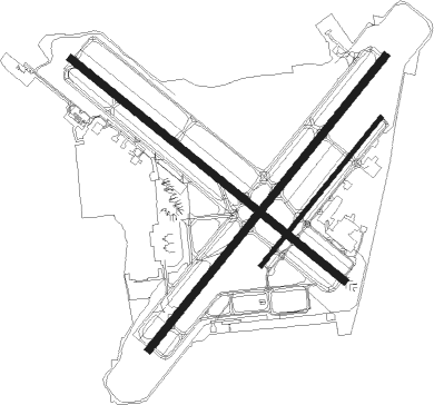
Runway info
Runway 4L / 22R  | ||
| length | 2290m (7513ft) | |
| bearing | 48° / 228° | |
| width | 46m (150ft) | |
| surface | concrete | |
| Runway 13 / 31 | ||
| length | 2137m (7011ft) | |
| bearing | 129° / 309° | |
| width | 46m (150ft) | |
| surface | asphalt | |
| displ threshold | 182m (597ft) / 96m (315ft) | |
| blast zone | 0m (0ft) / 20m (66ft) | |
| Runway 4R / 22L | ||
| length | 1159m (3802ft) | |
| bearing | 48° / 228° | |
| width | 23m (75ft) | |
| surface | asphalt | |
Nearby beacons
| code | identifier | dist | bearing | frequency |
|---|---|---|---|---|
| BT | RUNDI (BATON ROUGE) NDB | 4.3 | 309° | 284 |
| LSU | FIGHTING TIGER (BATON ROU VORTAC | 7.9 | 252° | 116.50 |
| HP | ANGER (HAMMOND) NDB | 37.9 | 84° | 212 |
| RQR | RESERVE VOR/DME | 39.5 | 128° | 110.80 |
| LF | LAFFS (LAFARETTE) NDB | 41.8 | 252° | 375 |
| LFT | LAFAYETTE VORTAC | 48.1 | 248° | 109.80 |
| MS | KINTE (NEW ORLEANS) NDB | 49.4 | 124° | 338 |
| MC | FERNI (MCCOMB) NDB | 54.4 | 42° | 413 |
| TBD | TIBBY (THIBODAUX) VOR/DME | 54.7 | 160° | 112 |
| BNZ | ABBEVILLE NDB | 57.8 | 244° | 230 |
| MCB | MC COMB VORTAC | 65.2 | 49° | 116.70 |
Instrument approach procedures
| runway | airway (heading) | route (dist, bearing) |
|---|---|---|
| RW04L | IBEKY (47°) | IBEKY 2800ft |
| RNAV | IBEKY 2800ft GOCET (7mi, 47°) 2000ft HOGTO (4mi, 48°) 820ft KBTR (3mi, 46°) 121ft (5465mi, 109°) 345ft KUREC (5456mi, 289°) 2300ft KUREC (turn) | |
| RW13 | ALIYA (95°) | ALIYA BOYAG (8mi, 48°) 2000ft |
| RW13 | DOCET (172°) | DOCET BOYAG (9mi, 228°) 2000ft |
| RNAV | BOYAG 2000ft DUNAY (6mi, 129°) 1400ft KBTR (5mi, 129°) 124ft (5465mi, 109°) 267ft FADAD (5454mi, 288°) 2300ft FADAD (turn) | |
| RW22R | KUREC (228°) | KUREC 2300ft |
| RNAV | KUREC 2300ft FIRNO (7mi, 228°) 1800ft WUMES (4mi, 228°) 660ft KBTR (2mi, 229°) 125ft (5465mi, 109°) 270ft IBEKY (5474mi, 288°) 2800ft IBEKY (turn) | |
| RW31 | EYEKI (296°) | EYEKI FADAD (5mi, 254°) 2100ft |
| RW31 | FADAD (310°) | FADAD 2100ft |
| RW31 | LSU (72°) | LSU ENERE (7mi, 138°) 2800ft BAPRE (11mi, 129°) 2800ft FADAD (8mi, 48°) 2100ft |
| RNAV | FADAD 2100ft NUHDA (10mi, 309°) 1700ft KBTR (5mi, 310°) 121ft (5465mi, 109°) 366ft BOYAG (5472mi, 289°) 2000ft BOYAG (turn) |
Disclaimer
The information on this website is not for real aviation. Use this data with the X-Plane flight simulator only! Data taken with kind consent from X-Plane 12 source code and data files. Content is subject to change without notice.