Burwell - Cram Field
Airport details
| Country | United States of America |
| State | Nebraska |
| Region | K3 |
| Airspace | Denver Ctr |
| Municipality | Garfield County |
| Elevation | 2183ft (665m) |
| Timezone | GMT -6 |
| Coordinates | 41.77758, -99.15021 |
| Magnetic var | |
| Type | land |
| Available since | X-Plane v10.40 |
| ICAO code | KBUB |
| IATA code | BUB |
| FAA code | BUB |
Communication
| Cram Field CTAF | 122.900 |
Nearby Points of Interest:
Burwell Carnegie Library
-Garfield County Frontier Fairgrounds
-Rad Slavin cis. 112 Z.C.B.J. Hall
-People's Unitarian Church
-Valley County Courthouse
-Dowse Sod House
-North Loup Bridge
-Former Wheeler County Courthouse
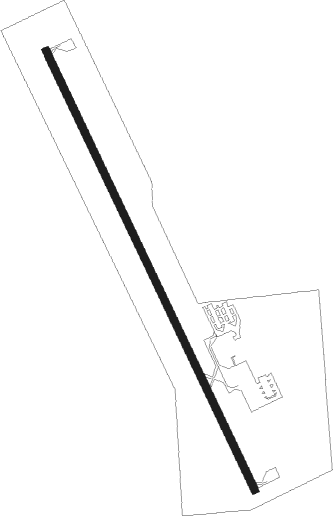
Runway info
| Runway 15 / 33 | ||
| length | 1190m (3904ft) | |
| bearing | 153° / 333° | |
| width | 18m (60ft) | |
| surface | asphalt | |
Nearby beacons
| code | identifier | dist | bearing | frequency |
|---|---|---|---|---|
| ODX | ORD NDB | 12.9 | 127° | 356 |
| CUZ | CUSTER CO. (BROKEN BOW) VOR/DME | 29.9 | 241° | 108.20 |
| OBH | WOLBACH VORTAC | 43.1 | 117° | 114.80 |
| ONL | O'NEILL VORTAC | 46.4 | 34° | 113.90 |
| ANW | AINSWORTH VOR/DME | 60.4 | 313° | 112.70 |
| GRI | GRAND ISLAND VOR/DME | 60.7 | 134° | 112 |
| GR | SANCY NDB | 66.1 | 137° | 380 |
| OZB | COZAD VOR | 66.7 | 223° | 109 |
Instrument approach procedures
| runway | airway (heading) | route (dist, bearing) |
|---|---|---|
| RW15 | RUGTE (153°) | RUGTE 4100ft |
| RNAV | RUGTE 4100ft SEYOT (6mi, 153°) 4000ft TORLE (3mi, 153°) 3160ft KBUB (3mi, 153°) 2212ft (5814mi, 113°) 2468ft GREYY (5811mi, 293°) 4400ft GREYY (turn) | |
| RW33 | GREYY (333°) | GREYY 4400ft |
| RNAV | GREYY 4400ft KODEE (6mi, 333°) 4000ft IBOTY (2mi, 333°) 3240ft KBUB (4mi, 333°) 2223ft (5814mi, 113°) 2583ft RUGTE (5817mi, 293°) 4100ft RUGTE (turn) |
Disclaimer
The information on this website is not for real aviation. Use this data with the X-Plane flight simulator only! Data taken with kind consent from X-Plane 12 source code and data files. Content is subject to change without notice.