Buffalo - Buffalo Niagara Intl
Airport details
| Country | United States of America |
| State | New York |
| Region | K6 |
| Airspace | Cleveland Ctr |
| Municipality | Town of Cheektowaga |
| Elevation | 724ft (221m) |
| Timezone | GMT -5 |
| Coordinates | 42.94031, -78.72417 |
| Magnetic var | |
| Type | land |
| Available since | X-Plane v10.40 |
| ICAO code | KBUF |
| IATA code | BUF |
| FAA code | BUF |
Communication
| Buffalo Niagara Intl ATIS | 135.350 |
| Buffalo Niagara Intl Clearance DEL | 124.700 |
| Buffalo Niagara Intl Ground Control | 133.200 |
| Buffalo Niagara Intl Tower | 120.500 |
| Buffalo Niagara Intl Approach/Departure | 126.150 |
| Buffalo Niagara Intl Approach/Departure | 126.500 |
Approach frequencies
| ILS-cat-I | RW32 | 109.95 | 18.00mi |
| ILS-cat-I | RW23 | 111.3 | 18.00mi |
| ILS-cat-I | RW05 | 108.5 | 18.00mi |
| 3° GS | RW32 | 109.95 | 18.00mi |
| 3° GS | RW23 | 111.3 | 18.00mi |
| 3° GS | RW05 | 108.5 | 18.00mi |
Nearby Points of Interest:
Garrison Cemetery
-Our Lady Help of Christians Chapel
-Williamsville Christian Church
-Former Reformed Mennonite Church
-St. Mary of the Angels Motherhouse Complex
-Entranceways at Main Street at Lamarck Drive and Smallwood Drive
-United States Post Office
-Entranceway at Main Street at Roycroft Boulevard
-Lancaster Municipal Building
-Miller-Mackey House
-Clark-Lester House
-Bruce-Briggs Brick Block
-John P. Sommers House
-Liebler-Rohl Gasoline Station
-DePew Lodge No. 823, Free and Accepted Masons
-Dr. John J. Nowak House
-Zuidema-Idsardi House
-Villa Maria Motherhouse Complex
-Herman B. VanPeyma House
-John Richardson House (Lancaster, New York)
-Warren Hull House
-Edward A. Diebolt House
-Public School No. 63
-University Park Historic District
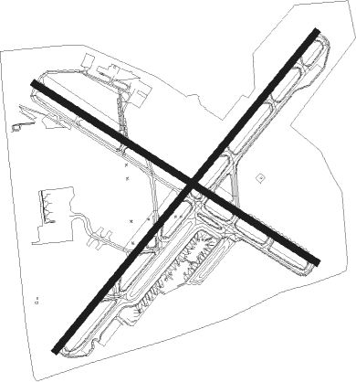
Runway info
Runway 5 / 23  | ||
| length | 2690m (8825ft) | |
| bearing | 53° / 233° | |
| width | 46m (150ft) | |
| surface | asphalt | |
| displ threshold | 163m (535ft) / 221m (725ft) | |
| blast zone | 61m (200ft) / 61m (200ft) | |
| Runway 14 / 32 | ||
| length | 2180m (7152ft) | |
| bearing | 119° / 299° | |
| width | 46m (150ft) | |
| surface | asphalt | |
| displ threshold | 98m (322ft) / 220m (722ft) | |
| blast zone | 61m (200ft) / 61m (200ft) | |
Nearby beacons
| code | identifier | dist | bearing | frequency |
|---|---|---|---|---|
| BUF | BUFFALO VOR/DME | 3.4 | 98° | 116.40 |
| BU | KLUMP (BUFFALO) NDB | 4.8 | 51° | 231 |
| GB | PLAZZ (BUFFALO) NDB | 5.6 | 234° | 204 |
| IA | KATHI (NIAGRA FALLS) NDB | 11.3 | 326° | 329 |
| IAG | NIAGARA FALLS TACAN | 14.6 | 306° | 111 |
| SN | ST CATHARINES NDB | 26.4 | 291° | 408 |
| DKK | DME | 36.3 | 231° | 116.20 |
| GEE | GENESEO VOR/DME | 44 | 96° | 108.20 |
| JHW | JAMESTOWN VOR/DME | 48.4 | 208° | 114.70 |
| TZ | GIBRALTAR POINT NDB | 49.6 | 315° | 257 |
| ZYZ | QUEENSWAY (TORONTO) NDB | 54.4 | 310° | 368 |
| YYZ | TORONTO VOR/DME | 58.5 | 308° | 112.15 |
| YO | DME-ILS | 59.1 | 351° | 111.35 |
| OO | OSHAWA NDB | 59.3 | 350° | 391 |
| YTP | PEARSON (TORONTO) VOR/DME | 60.1 | 308° | 116.55 |
| ELZ | DME | 60.3 | 140° | 111.40 |
| ZTO | WOODHILL (TORONTO) NDB | 64.2 | 309° | 403 |
| KZ | BUTTONVILLE NDB | 65.1 | 329° | 248 |
Departure and arrival routes
| Transition altitude | 18000ft |
| Transition level | 18000ft |
| SID end points | distance | outbound heading | |
|---|---|---|---|
| RW05 | |||
| BUF8 | 26mi | 268° | |
| RW14 | |||
| BUF8 | 26mi | 268° | |
| RW23 | |||
| BUF8 | 26mi | 268° | |
| RW32 | |||
| BUF8 | 26mi | 268° | |
Instrument approach procedures
| runway | airway (heading) | route (dist, bearing) |
|---|---|---|
| RW05-Y | LANGS (22°) | LANGS RITEE (6mi, 33°) 3700ft WABUS (8mi, 310°) 3000ft |
| RW05-Y | VICCU (78°) | VICCU WABUS (8mi, 121°) 3000ft |
| RW05-Y | WABUS (53°) | WABUS 3000ft |
| RNAV | WABUS 3000ft HIRIN (7mi, 53°) 2400ft LANEC (3mi, 53°) 1520ft KBUF (3mi, 56°) 727ft (4911mi, 119°) 908ft TRAVA (4904mi, 299°) 3000ft TRAVA (turn) | |
| RW05-Z | GOALS (8°) | GOALS 4000ft FORMN (5mi, 326°) 2400ft JAXYN (2mi, 12°) 1700ft |
| RW05-Z | LKERI (64°) | LKERI 4000ft EBBED (5mi, 70°) 2300ft JAXYN (2mi, 62°) 1700ft |
| RW05-Z | ROZWL (75°) | ROZWL 4000ft ZURUS (5mi, 88°) 2300ft JAXYN (2mi, 72°) 1700ft |
| RW05-Z | SNOPO (305°) | SNOPO 5000ft GLUTE (3mi, 233°) 3900ft FORMN (4mi, 277°) 2400ft JAXYN (2mi, 12°) 1700ft |
| RW05-Z | WABUS (53°) | WABUS 3500ft ONCET (6mi, 53°) 2600ft JAXYN (3mi, 53°) 1700ft |
| RNAV | JAXYN 1700ft KBUF (4mi, 55°) 727ft TRAVA (12mi, 52°) 3000ft TRAVA (turn) | |
| RW14 | DAVVK (79°) | DAVVK WUSOL (12mi, 48°) 3000ft |
| RNAV | WUSOL 3000ft JNKAL (7mi, 95°) 2300ft KBUF (6mi, 117°) 753ft (4911mi, 119°) 1080ft WALES (4899mi, 299°) 3500ft WALES (turn) | |
| RW23-Y | BULGE (157°) | BULGE WASKI (19mi, 133°) 3000ft TRAVA (8mi, 125°) 3000ft |
| RW23-Y | ROC (260°) | ROC TOPKE (33mi, 261°) 3000ft TRAVA (8mi, 305°) 3000ft |
| RW23-Y | TRAVA (232°) | TRAVA 3000ft |
| RNAV | TRAVA 3000ft BERKI (7mi, 233°) 2300ft KBUF (5mi, 231°) 777ft (4911mi, 119°) 926ft WABUS (4919mi, 298°) 3000ft WABUS (turn) | |
| RW23-Z | COZZS (305°) | COZZS 5000ft EFFCT (3mi, 53°) 4000ft JEDAR (3mi, 17°) 3200ft ZUDAT (2mi, 310°) 2600ft BIILS (2mi, 263°) 1800ft |
| RW23-Z | SUSKE (77°) | SUSKE 5500ft BUFST (7mi, 60°) 5500ft FOTBL (5mi, 60°) 5000ft ZADUM (3mi, 53°) 3900ft JABET (4mi, 91°) 2700ft BIILS (3mi, 182°) 1800ft |
| RW23-Z | TRAVA (232°) | TRAVA 3500ft BUULS (6mi, 233°) 2700ft BIILS (3mi, 233°) 1800ft |
| RW23-Z | WNNGS (277°) | WNNGS 4000ft JEDAR (3mi, 335°) 3200ft ZUDAT (2mi, 310°) 2600ft BIILS (2mi, 263°) 1800ft |
| RNAV | BIILS 1800ft KBUF (4mi, 230°) 777ft WABUS (13mi, 233°) 3000ft WABUS (turn) | |
| RW32 | CLUNG (261°) | CLUNG RUPKE (19mi, 249°) 3500ft WALES (8mi, 226°) 3500ft |
| RW32 | LANGS (22°) | LANGS ROLSE (15mi, 66°) 4700ft WALES (7mi, 45°) 3500ft |
| RW32 | WALES (299°) | WALES 3500ft |
| RNAV | WALES 3500ft MIRTE (5mi, 299°) 2900ft DEPEW (3mi, 299°) 2300ft FABVO (2mi, 299°) 1520ft KBUF (3mi, 301°) 762ft (4911mi, 119°) 908ft YULCU (4917mi, 299°) SUSKE (10mi, 232°) 3000ft SUSKE (turn) |
Disclaimer
The information on this website is not for real aviation. Use this data with the X-Plane flight simulator only! Data taken with kind consent from X-Plane 12 source code and data files. Content is subject to change without notice.