Burbank - Bob Hope Burbank
Airport details
| Country | United States of America |
| State | California |
| Region | K2 |
| Airspace | Los Angeles Ctr |
| Municipality | Burbank |
| Elevation | 774ft (236m) |
| Timezone | GMT -8 |
| Coordinates | 34.20070, -118.35867 |
| Magnetic var | |
| Type | land |
| Available since | X-Plane v10.32 |
| ICAO code | KBUR |
| IATA code | BUR |
| FAA code | BUR |
Communication
| Bob Hope Burbank ATIS | 134.500 |
| Bob Hope Burbank ATIS | 135.125 |
| Bob Hope Burbank UNICOM | 122.950 |
| Bob Hope Burbank Clearance DEL | 118.000 |
| Bob Hope Burbank Ground Control | 123.900 |
| Bob Hope Burbank Tower | 118.700 |
| Bob Hope Burbank Tower | 132.325 |
| Bob Hope Burbank SOCAL Approach/Departure | 124.600 |
| Bob Hope Burbank SOCAL Approach/Departure | 134.200 |
| Bob Hope Burbank SOCAL Approach/Departure | 135.050 |
| Bob Hope Burbank SOCAL Approach/Departure | 120.400 |
Approach frequencies
| ILS-cat-I | RW08 | 109.5 | 18.00mi |
| 3° GS | RW08 | 109.5 | 18.00mi |
Nearby Points of Interest:
Portal of the Folded Wings Shrine to Aviation
-North Hollywood Amelia Earhart Regional Library
-The Great Wall of Los Angeles
-Ard Eevin
-Van Nuys Branch
-Highland-Camrose Bungalow Village
-Lasky-DeMille Barn
-C.E. Toberman Estate
-Villa Bonita
-Montecito Apartments
-El Cabrillo
-Hollywood Tower
-Storer House
-Halifax Apartments
-Whitley Court
-Hollywood Boulevard Commercial and Entertainment District
-Security Trust and Savings
-Lovell House
-Rancho Los Encinos
-United States Post Office
-Crossroads of the World
-Andalusia
-Colonial House
-Guaranty Building
-Patio del Moro
Runway info
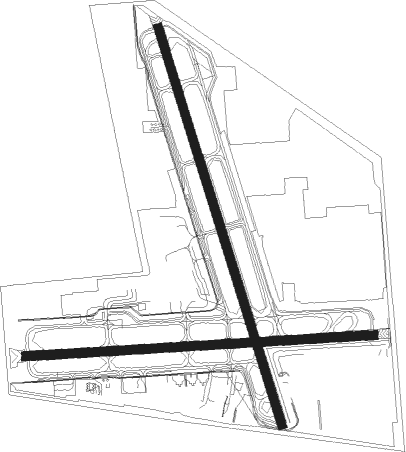
Runway 8 / 26  | ||
| length | 1765m (5791ft) | |
| bearing | 91° / 271° | |
| width | 46m (151ft) | |
| surface | asphalt | |
| Runway 15 / 33 | ||
| length | 2104m (6903ft) | |
| bearing | 165° / 345° | |
| width | 46m (151ft) | |
| surface | asphalt | |
| displ threshold | 280m (919ft) / 109m (358ft) | |
Nearby beacons
| code | identifier | dist | bearing | frequency |
|---|---|---|---|---|
| VNY | VAN NUYS VOR/DME | 6.7 | 280° | 113.10 |
| SMO | SANTA MONICA VOR/DME | 12.4 | 207° | 110.80 |
| LAX | LOS ANGELES VORTAC | 16.4 | 195° | 113.60 |
| FIM | FILLMORE VORTAC | 27.5 | 287° | 112.50 |
| SLI | SEAL BEACH (LOS ALAMITOS) VORTAC | 29.2 | 144° | 115.70 |
| POM | POMONA VORTAC | 29.3 | 102° | 110.40 |
| PMD | PALMDALE VORTAC | 29.7 | 34° | 114.50 |
| LHS | LAKE HUGHES VORTAC | 30.9 | 336° | 114.35 |
| VTU | VENTURA (OXNARD) VOR/DME | 34.7 | 263° | 108.20 |
| CMA | CAMARILLO VOR/DME | 36.5 | 271° | 115.80 |
| NTD | POINT MUGU (OXNARD) TACAN | 38.2 | 264° | 110.60 |
| GMN | GORMAN VORTAC | 43.9 | 320° | 116.10 |
| ELB | EL TORO (SANTA ANA) VOR/DME | 44.3 | 130° | 117.20 |
| PDZ | PARADISE (ONTARIO) VORTAC | 44.5 | 109° | 112.20 |
| RAL | RIVERSIDE VOR | 47.5 | 105° | 112.40 |
| SXC | SANTA CATALINA VORTAC | 49.6 | 184° | 111.40 |
| SB | PETIS (SAN BERNARDINO) NDB | 50 | 98° | 397 |
| VCV | VICTORVILLE VOR/DME | 53.5 | 68° | 109.05 |
| EDW | EDWARDS VORTAC | 56.2 | 39° | 116.40 |
| NFG | CAMP PENDLETON (OCEANSIDE TACAN | 73.8 | 134° | 111.80 |
| OCN | OCEANSIDE VORTAC | 74.3 | 136° | 115.30 |
Departure and arrival routes
| Transition altitude | 18000ft |
| Transition level | 18000ft |
| SID end points | distance | outbound heading | |
|---|---|---|---|
| RW08 | |||
| SLAPP2 | 111mi | 65° | |
| VVERA2 | 100mi | 73° | |
| ELMOO9 | 15mi | 110° | |
| VNY3 | 14mi | 293° | |
| OROSZ2 | 86mi | 325° | |
| RW15 | |||
| SLAPP2 | 111mi | 65° | |
| VVERA2 | 100mi | 73° | |
| ELMOO9 | 15mi | 110° | |
| VNY3 | 14mi | 293° | |
| OROSZ2 | 86mi | 325° | |
| RW26 | |||
| SLAPP2 | 111mi | 65° | |
| VVERA2 | 100mi | 73° | |
| ELMOO9 | 15mi | 110° | |
| VNY3 | 14mi | 293° | |
| OROSZ2 | 86mi | 325° | |
| RW33 | |||
| SLAPP2 | 111mi | 65° | |
| VVERA2 | 100mi | 73° | |
| ELMOO9 | 15mi | 110° | |
| VNY3 | 14mi | 293° | |
| OROSZ2 | 86mi | 325° | |
| STAR starting points | distance | inbound heading | |
|---|---|---|---|
| ALL | |||
| LYNXX8 | 22.0 | 143° | |
| WEESL1 | 45.6 | 148° | |
| THRNE3 | 64.1 | 280° | |
| RW08 | |||
| ROKKR2 | 29.0 | 107° | |
| FERN7 | 27.5 | 107° | |
| JANNY5 | 21.9 | 180° | |
| RW15 | |||
| ROKKR2 | 29.0 | 107° | |
| RW33 | |||
| ROKKR2 | 29.0 | 107° | |
Instrument approach procedures
| runway | airway (heading) | route (dist, bearing) |
|---|---|---|
| RW08-Y | MIKEI (99°) | MIKEI 7000ft SILEX (10mi, 110°) 4500ft YEBUN (5mi, 91°) 3000ft WESKI (1mi, 91°) 2700ft |
| RW08-Y | WABBT (128°) | WABBT 6000ft NIBYI (5mi, 178°) 5100ft ZEMEP (3mi, 176°) 4200ft HIMVI (3mi, 142°) 3400ft YEBUN (1mi, 102°) 3000ft WESKI (1mi, 91°) 2700ft |
| RNAV | WESKI 2700ft KBUR (7mi, 89°) 787ft (6794mi, 106°) 1200ft COTSI (6802mi, 286°) YOLYY (27mi, 274°) 4600ft YOLYY (turn) | |
| RW08-Z | MIKEI (99°) | MIKEI 7000ft SILEX (10mi, 110°) 4100ft |
| RW08-Z | SILEX (90°) | SILEX 8000ft SILEX (turn) 4100ft |
| RW08-Z | VTU (83°) | VTU TOAKS (14mi, 72°) 4600ft SILEX (8mi, 91°) 4100ft |
| RNAV | SILEX 4100ft BUBNE (5mi, 91°) 3000ft HIMEN (6mi, 91°) 1201ft (6796mi, 106°) 1201ft COTSI (6802mi, 286°) VTU (29mi, 274°) 4600ft VTU (turn) | |
| RWNVA | SAUGS (160°) | SAUGS CEZKA (8mi, 228°) 5200ft |
| RWNVA | VAZCU (126°) | VAZCU CEZKA (5mi, 110°) 5200ft |
| RNAV | CEZKA 5200ft SUMXY (8mi, 131°) 4100ft IGAXY (7mi, 131°) 2320ft (6795mi, 106°) 2320ft COTSI (6802mi, 286°) VTU (29mi, 274°) 4600ft VTU (turn) |
Holding patterns
| STAR name | hold at | type | turn | heading* | altitude | leg | speed limit |
|---|---|---|---|---|---|---|---|
| FERN7 | REYES | VHF | right | 310 (130)° | < 45000ft | 1.5min timed | ICAO rules |
| LYNXX8 | LYNXX | VHF | left | 60 (240)° | 1.0min timed | ICAO rules | |
| *) magnetic outbound (inbound) holding course | |||||||
Disclaimer
The information on this website is not for real aviation. Use this data with the X-Plane flight simulator only! Data taken with kind consent from X-Plane 12 source code and data files. Content is subject to change without notice.