Burley - Burley Muni
Airport details
| Country | United States of America |
| State | Idaho |
| Region | K1 |
| Airspace | Salt Lake City Ctr |
| Municipality | Burley |
| Elevation | 4147ft (1264m) |
| Timezone | GMT -7 |
| Coordinates | 42.54261, -113.77153 |
| Magnetic var | |
| Type | land |
| Available since | X-Plane v10.40 |
| ICAO code | KBYI |
| IATA code | BYI |
| FAA code | BYI |
Communication
| BURLEY MUNI ASOS | 135.575 |
| BURLEY MUNI CTAF | 122.900 |
| BURLEY MUNI TWIN FALLS Approach/Departure | 126.700 |
Nearby Points of Interest:
Cassia County Courthouse
-Empire School
-Albion Methodist Church
-Minidoka National Historic Site
-Minidoka War Relocation Center
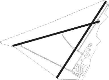
Runway info
Runway 6 / 24  | ||
| length | 1240m (4068ft) | |
| bearing | 82° / 262° | |
| width | 23m (75ft) | |
| surface | asphalt | |
| displ threshold | 244m (801ft) / 36m (118ft) | |
| Runway 2 / 20 | ||
| length | 1248m (4094ft) | |
| bearing | 46° / 226° | |
| width | 24m (80ft) | |
| surface | asphalt | |
| displ threshold | 191m (627ft) / 93m (305ft) | |
Nearby beacons
| code | identifier | dist | bearing | frequency |
|---|---|---|---|---|
| BYI | BURLEY VOR/DME | 4.7 | 292° | 114.10 |
| TW | STRIK (TWIN FALLS) NDB | 26 | 264° | 389 |
| TWF | TWIN FALLS VORTAC | 32 | 265° | 113.10 |
| HLE | HAILEY NDB | 51.6 | 329° | 220 |
Instrument approach procedures
| runway | airway (heading) | route (dist, bearing) |
|---|---|---|
| RW20 | IREME (227°) | IREME 7000ft |
| RW20 | MALTT (322°) | MALTT MUTOE (13mi, 46°) 8200ft IREME (5mi, 300°) 7000ft |
| RW20 | SHONE (128°) | SHONE JADUP (16mi, 96°) 8200ft IREME (5mi, 119°) 7000ft |
| RNAV | IREME 7000ft HIKLO (6mi, 226°) 6000ft JAMID (3mi, 226°) 4800ft KBYI (2mi, 229°) 4182ft (6443mi, 111°) 4554ft IREME (6434mi, 291°) 7000ft IREME (turn) |
Disclaimer
The information on this website is not for real aviation. Use this data with the X-Plane flight simulator only! Data taken with kind consent from X-Plane 12 source code and data files. Content is subject to change without notice.