Bozeman - Bozeman Yellowstone Intl
Airport details
| Country | United States of America |
| State | Montana |
| Region | K1 |
| Airspace | Salt Lake City Ctr |
| Municipality | Gallatin County |
| Elevation | 4471ft (1363m) |
| Timezone | GMT -7 |
| Coordinates | 45.77340, -111.15078 |
| Magnetic var | |
| Type | land |
| Available since | X-Plane v10.40 |
| ICAO code | KBZN |
| IATA code | BZN |
| FAA code | BZN |
Communication
| Bozeman Yellowstone Intl ATIS/ASOS | 135.425 |
| Bozeman Yellowstone Intl Ground Control | 121.800 |
| Bozeman Yellowstone Intl Tower/CTAF | 118.200 |
| Bozeman Yellowstone Intl BIG SKY Approach | 118.975 |
| Bozeman Yellowstone Intl BIG SKY Departure | 118.975 |
Approach frequencies
| ILS-cat-I | RW12 | 109.3 | 18.00mi |
| 3° GS | RW12 | 109.3 | 18.00mi |
Nearby Points of Interest:
Belgrade City Hall and Jail
-Charles Lundwall Building
-Gallatin County Courthouse
-Beall Park Community Center
-Gallatin County High School
-Bon Ton Historic District
-Bohart House
-Bozeman Carnegie Library
-R.T. Barnett and Company Building
-Spieth and Krug Brewery
-Samuel Lewis House
-Bozeman National Fish Hatchery
-Missouri Headwaters State Park
-Adams Block
-Rolfson House
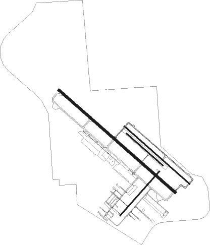
Runway info
Runway 12 / 30  | ||
| length | 2739m (8986ft) | |
| bearing | 126° / 306° | |
| width | 46m (150ft) | |
| surface | asphalt | |
| blast zone | 54m (177ft) / 57m (187ft) | |
| Runway 11 / 29 | ||
| length | 1537m (5043ft) | |
| bearing | 126° / 306° | |
| width | 23m (75ft) | |
| surface | asphalt | |
| blast zone | 44m (144ft) / 46m (151ft) | |
| Runway 3 / 21 | ||
| length | 1040m (3412ft) | |
| bearing | 56° / 236° | |
| width | 23m (75ft) | |
| surface | asphalt | |
| displ threshold | 234m (768ft) / 0m (0ft) | |
| Runway 11R / 29L | ||
| length | 853m (2799ft) | |
| bearing | 126° / 306° | |
| width | 24m (80ft) | |
| surface | grass | |
Nearby beacons
| code | identifier | dist | bearing | frequency |
|---|---|---|---|---|
| BZN | BOZEMAN VOR/DME | 0.6 | 336° | 112.40 |
| BZ | MANNI (BOZEMAN) NDB | 8.1 | 306° | 266 |
| LVM | LIVINGSTON VOR/DME | 29.9 | 96° | 116.10 |
| EKS | ENNIS NDB | 36.9 | 225° | 286 |
| HAU | HAUSER (HELENA) NDB | 54 | 323° | 386 |
| HLN | HELENA VORTAC | 60.1 | 316° | 117.70 |
Departure and arrival routes
| Transition altitude | 18000ft |
| Transition level | 18000ft |
| SID end points | distance | outbound heading | |
|---|---|---|---|
| RW12 | |||
| BOBKT4 | 185mi | 129° | |
| HIA5, TEERX4 | 43mi | 275° | |
| RW30 | |||
| BOBKT4 | 185mi | 129° | |
| HIA5, TEERX4 | 43mi | 275° | |
Instrument approach procedures
| runway | airway (heading) | route (dist, bearing) |
|---|---|---|
| RW12-Y | GODFE (150°) | GODFE FEVIM (19mi, 174°) 8000ft |
| RW12-Y | HIA (95°) | HIA HEBIV (19mi, 82°) 9500ft THESE (8mi, 82°) 8300ft FEVIM (6mi, 88°) 8000ft |
| RW12-Y | LVM (276°) | LVM QIVHY (32mi, 285°) 12300ft FEVIM (11mi, 285°) 9000ft FEVIM (turn) 8000ft |
| RW12-Y | RANEY (34°) | RANEY POPWI (14mi, 351°) 10000ft FEVIM (13mi, 350°) 8000ft FEVIM (turn) 8000ft |
| RNAV | FEVIM 8000ft HAYCI (5mi, 125°) 7300ft OLENY (2mi, 126°) 6800ft KBZN (8mi, 127°) 4478ft (6281mi, 112°) 4693ft WOLAT (6278mi, 292°) CISED (10mi, 249°) 8300ft THESE (21mi, 320°) 8300ft THESE (turn) | |
| RW12-Z | GODFE (150°) | GODFE ZIVTI (16mi, 165°) 8100ft HUXAN (5mi, 165°) 7400ft WOSAG (4mi, 126°) 6400ft JURAL (3mi, 126°) 5600ft |
| RW12-Z | HIA (95°) | HIA THESE (27mi, 82°) 8300ft HUXAN (9mi, 100°) 7400ft WOSAG (4mi, 126°) 6400ft JURAL (3mi, 126°) 5600ft |
| RW12-Z | JOXIT (34°) | JOXIT RANEY (5mi, 32°) 11200ft WOMET (6mi, 32°) 9600ft WINIX (10mi, 334°) 8100ft TETBY (3mi, 12°) 7200ft JURAL (5mi, 87°) 5600ft |
| RW12-Z | LVM (276°) | LVM JAPER (23mi, 266°) 9000ft GATEY (10mi, 271°) 9000ft KASRE (7mi, 313°) 8300ft WINIX (turn) 8100ft TETBY (3mi, 12°) 7200ft JURAL (5mi, 87°) 5600ft |
| RW12-Z | THESE (114°) | THESE HUXAN (9mi, 100°) 7400ft WOSAG (4mi, 126°) 6400ft JURAL (3mi, 126°) 5600ft |
| RNAV | JURAL 5600ft KBZN (5mi, 127°) 4478ft HETSI (3mi, 123°) HAXAG (11mi, 243°) THESE (22mi, 323°) 8300ft THESE (turn) | |
| RW30 | GODFE (150°) | GODFE THESE (19mi, 199°) 8300ft FIDEP (18mi, 131°) 8300ft CUTUR (5mi, 126°) 7800ft FIBNY (2mi, 113°) 7500ft MODJY (2mi, 91°) 7400ft CIVMO (2mi, 64°) 6800ft JANOK (2mi, 25°) 6300ft SITRE (2mi, 330°) 5700ft |
| RW30 | HIA (95°) | HIA KECOT (40mi, 102°) 8600ft FIBNY (5mi, 102°) 7500ft MODJY (2mi, 91°) 7400ft CIVMO (2mi, 64°) 6800ft JANOK (2mi, 25°) 6300ft SITRE (2mi, 330°) 5700ft |
| RW30 | JOXIT (34°) | JOXIT RANEY (5mi, 32°) 11300ft WOMET (6mi, 32°) 9000ft MODJY (7mi, 79°) 7400ft CIVMO (2mi, 64°) 6800ft JANOK (2mi, 25°) 6300ft SITRE (2mi, 330°) 5700ft |
| RW30 | LVM (276°) | LVM PESRE (14mi, 262°) 9000ft TIYOL (4mi, 262°) 8800ft LAVPE (2mi, 270°) 8300ft JAPER (3mi, 290°) 7300ft MOSNE (3mi, 303°) 6300ft SITRE (2mi, 306°) 5700ft |
| RNAV | SITRE 5700ft KBZN (4mi, 304°) 4507ft HUXAN (12mi, 306°) THESE (9mi, 280°) 8300ft THESE (turn) | |
| RWNVA | BZN (156°) | BZN SURPE (18mi, 116°) 11000ft SURPE (turn) 11000ft |
| RWNVA | LVM (276°) | LVM SURPE (16mi, 257°) 11000ft |
| RWNVA | WOMET (35°) | WOMET SURPE (19mi, 90°) 11000ft SURPE (turn) 11000ft |
| RNAV | SURPE 11000ft ZIPGO (7mi, 281°) 10000ft KBZN (10mi, 305°) 4507ft (6281mi, 112°) 4873ft FALIA (6288mi, 292°) 10000ft FALIA (turn) 10000ft |
Disclaimer
The information on this website is not for real aviation. Use this data with the X-Plane flight simulator only! Data taken with kind consent from X-Plane 12 source code and data files. Content is subject to change without notice.