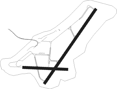
Cumberland - Greater Cumberland Regional
Airport details
| Country | United States of America |
| State | West Virginia |
| Region | K6 |
| Airspace | Cleveland Ctr |
| Municipality | Wiley Ford |
| Elevation | 773ft (236m) |
| Timezone | GMT -5 |
| Coordinates | 39.61539, -78.76081 |
| Magnetic var | |
| Type | land |
| Available since | X-Plane v10.40 |
| ICAO code | KCBE |
| IATA code | CBE |
| FAA code | CBE |
Communication
| Greater Cumberland Regional AWOS 3 | 128.625 |
| Greater Cumberland Regional CTAF/UNICOM | 122.800 |
| Greater Cumberland Regional JOHNSTOWN ApproachROACH | 121.200 |
| Greater Cumberland Regional JOHNSTOWN DepartureARTURE | 121.200 |
Approach frequencies
| LOC | RW23 | 110.5 | 18.00mi |
Nearby Points of Interest:
Chapel Hill Historic District
-Footer's Dye Works
-Klots Throwing Company Mill
-Francis Haley House
-Rolling Mill Historic District
-Western Maryland Railway Station (Cumberland, Maryland)
-Queen City Hotel
-16 Altamont Terrace
-Public Safety Building
-Bell Tower Building
-City Hall
-Cumberland YMCA
-Thomas Koon House
-George Truog House
-Greene Street Historic District
-200-208 Decatur Street
-African Methodist Episcopal Church (Cumberland, Maryland)
-Canada Hose Company Building
-Wright Butler House
-Town Clock Church
-Decatur Heights Historic District
-Folck's Mill
-La Vale Tollgate House
-Union Grove Schoolhouse
-Phoenix Mill Farm
Nearby beacons
| code | identifier | dist | bearing | frequency |
|---|---|---|---|---|
| GRV | DME | 13.4 | 274° | 112.30 |
| ESL | KESSEL VOR/DME | 25.7 | 210° | 110.80 |
| SYS | STOYSTOWN (SOMERSET) NDB | 29.1 | 342° | 209 |
| IHD | INDIAN HEAD VORTAC | 34.9 | 301° | 108.20 |
| THS | SAINT THOMAS VORTAC | 41.9 | 69° | 115 |
| HGR | HAGERSTOWN VOR | 42.1 | 85° | 109.80 |
| JST | JOHNSTOWN VOR/DME | 42.2 | 354° | 113 |
| MRB | MARTINSBURG VORTAC | 44.4 | 104° | 112.10 |
| VV | CAMOR (CONNELLSVILLE) NDB | 48.1 | 285° | 299 |
| LDN | LINDEN VORTAC | 52.4 | 144° | 114.30 |
| REC | REVLOC VOR/DME | 55.9 | 1° | 110.60 |
| LUA | CAVERNS (LURAY) NDB | 56.6 | 163° | 245 |
| CSN | CASANOVA VORTAC | 71.8 | 137° | 116.30 |
Instrument approach procedures
| runway | airway (heading) | route (dist, bearing) |
|---|---|---|
| RW05 | HEKPA (25°) | HEKPA 5400ft |
| RNAV | HEKPA 5400ft JIRMO (9mi, 24°) 2800ft KAGPE (3mi, 24°) 1920ft LIDVE (3mi, 24°) 922ft (4887mi, 117°) 1175ft HOLOE (4883mi, 297°) 4500ft HOLOE (turn) 4500ft | |
| RW23 | CADIR (245°) | CADIR CIDAS (8mi, 277°) 5400ft |
| RW23 | CIDAS (227°) | CIDAS 5400ft |
| RW23 | ZIDUP (205°) | ZIDUP CIDAS (9mi, 154°) 5400ft |
| RNAV | CIDAS 5400ft WANVO (7mi, 227°) 3800ft WUVUK (2mi, 227°) 3400ft ZOBOB (4mi, 226°) 2080ft KCBE (4mi, 227°) 830ft (4887mi, 117°) 1220ft KEYER (4884mi, 297°) 5000ft KEYER (turn) |
Disclaimer
The information on this website is not for real aviation. Use this data with the X-Plane flight simulator only! Data taken with kind consent from X-Plane 12 source code and data files. Content is subject to change without notice.

