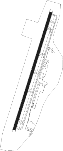
Charlottesville - Charlottesville Albemarle
Airport details
| Country | United States of America |
| State | Virginia |
| Region | K6 |
| Airspace | Washington Ctr |
| Municipality | Albemarle County |
| Elevation | 639ft (195m) |
| Timezone | GMT -5 |
| Coordinates | 38.13964, -78.45234 |
| Magnetic var | |
| Type | land |
| Available since | X-Plane v10.40 |
| ICAO code | KCHO |
| IATA code | CHO |
| FAA code | CHO |
Communication
| Charlottesville Albemarle ATIS | 118.425 |
| Charlottesville Albemarle CTAF | 124.500 |
| Charlottesville Albemarle UNICOM | 122.950 |
| Charlottesville Albemarle Ground Control | 121.900 |
| Charlottesville Albemarle Tower | 124.500 |
| Charlottesville Albemarle POTOMAC Approach/Departure | 132.850 |
Approach frequencies
| ILS-cat-I | RW03 | 111.7 | 18.00mi |
| 3° GS | RW03 | 111.7 | 18.00mi |
Nearby beacons
| code | identifier | dist | bearing | frequency |
|---|---|---|---|---|
| GVE | GORDONSVILLE VORTAC | 16 | 113° | 115.60 |
| SH | STAUT(STAUNTON-WAYNESBORO-HARR NDB | 24.1 | 277° | 375 |
| MSQ | NAILR (CULPEPER) NDB | 31.9 | 60° | 351 |
| LUA | CAVERNS (LURAY) NDB | 33.6 | 358° | 245 |
| MOL | MONTEBELLO VOR/DME | 34.1 | 250° | 115.30 |
| CSN | CASANOVA VORTAC | 40.8 | 49° | 116.30 |
| LDN | LINDEN VORTAC | 44.4 | 19° | 114.30 |
| FAK | FLAT ROCK VORTAC | 47.1 | 134° | 113.30 |
| LY | BOJAR (LYNCHBURG) NDB | 64.7 | 222° | 385 |
| LYH | LYNCHBURG VOR/DME | 64.9 | 222° | 109.20 |
| AML | ARMEL (WASH.,D.C.) VOR/DME | 66.5 | 51° | 113.50 |
Instrument approach procedures
| runway | airway (heading) | route (dist, bearing) |
|---|---|---|
| RW03 | GVE (293°) | GVE WULDU (20mi, 259°) 3400ft WULDU (turn) 3400ft |
| RW03 | MITER (121°) | MITER WULDU (17mi, 175°) 5000ft WULDU (turn) 3400ft |
| RW03 | ROMAN (43°) | ROMAN WULDU (13mi, 58°) 3400ft |
| RNAV | WULDU 3400ft SIPME (7mi, 27°) 2600ft JITIV (3mi, 27°) 1480ft KCHO (3mi, 27°) 694ft (4861mi, 116°) 2000ft GVE (4846mi, 296°) 4000ft GVE (turn) | |
| RW21-Y | WITTO (200°) | WITTO 4300ft |
| RNAV | WITTO 4300ft ECEUS (3mi, 206°) 3400ft MUSOJ (3mi, 206°) 2400ft WUBAK (3mi, 190°) 1300ft ORMEY (2mi, 190°) 827ft (4861mi, 116°) 1100ft GVE (4846mi, 296°) 4000ft GVE (turn) | |
| RW21-Z | GVE (293°) | GVE WIKNI (16mi, 356°) 3500ft FOMIV (9mi, 288°) 3500ft |
| RW21-Z | HOODE (221°) | HOODE FOMIV (11mi, 235°) 3500ft |
| RNAV | FOMIV 3500ft APUSE (6mi, 207°) 2600ft KCHO (7mi, 207°) 668ft (4861mi, 116°) 1100ft GVE (4846mi, 296°) 4000ft GVE (turn) |
Disclaimer
The information on this website is not for real aviation. Use this data with the X-Plane flight simulator only! Data taken with kind consent from X-Plane 12 source code and data files. Content is subject to change without notice.
