Chico - Chico Muni
Airport details
| Country | United States of America |
| State | California |
| Region | K2 |
| Airspace | Oakland Ctr |
| Municipality | Chico |
| Elevation | 234ft (71m) |
| Timezone | GMT -8 |
| Coordinates | 39.79666, -121.85484 |
| Magnetic var | |
| Type | land |
| Available since | X-Plane v10.40 |
| ICAO code | KCIC |
| IATA code | CIC |
| FAA code | CIC |
Communication
| Chico Muni AWOS 3 | 119.675 |
| Chico Muni CTAF | 121.000 |
| Chico Muni UNICOM | 122.950 |
| Chico Muni Ground Control | 121.900 |
| Chico Muni Tower | 121.000 |
Approach frequencies
| ILS-cat-I | RW13L | 111.3 | 18.00mi |
| 3° GS | RW13L | 111.3 | 18.00mi |
Nearby Points of Interest:
Silberstein Park Building
-Chico Midtown Station
-South Campus Neighborhood
-A. H. Chapman House
-Gianella Bridge
-Maywood Woman's Club
-United States Post Office (Willows, California)
-Old Bidwell Bar Bridge
-Saint Mary's Parish
-Odd Fellows Building
-Old Bank of America Building
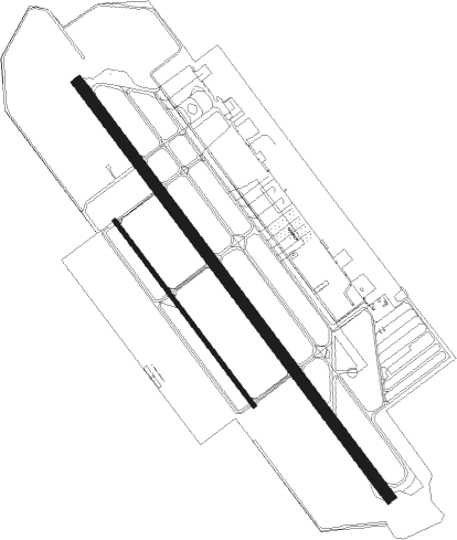
Runway info
Runway 13L / 31R  | ||
| length | 2049m (6722ft) | |
| bearing | 140° / 320° | |
| width | 46m (150ft) | |
| surface | asphalt | |
| blast zone | 61m (200ft) / 62m (203ft) | |
| Runway 13R / 31L | ||
| length | 916m (3005ft) | |
| bearing | 140° / 320° | |
| width | 18m (60ft) | |
| surface | asphalt | |
Nearby beacons
| code | identifier | dist | bearing | frequency |
|---|---|---|---|---|
| RBL | RED BLUFF VORTAC | 25.2 | 308° | 115.70 |
| MYV | MARYSVILLE VOR/DME | 43.9 | 158° | 110.80 |
| BAB | BEALE (MARYSVILLE) TACAN | 44.1 | 148° | 108.60 |
| ILA | WILLIAMS VORTAC | 44.2 | 193° | 114.40 |
| RDD | REDDING VOR/DME | 47 | 328° | 108.40 |
Departure and arrival routes
| Transition altitude | 18000ft |
| Transition level | 18000ft |
| SID end points | distance | outbound heading | |
|---|---|---|---|
| RW13 (ALL) | |||
| CIC5 | 42mi | 322° | |
| RW31 (ALL) | |||
| CIC5 | 42mi | 322° | |
Instrument approach procedures
| runway | airway (heading) | route (dist, bearing) |
|---|---|---|
| RW13L | RBL (128°) | RBL ZOTWY (12mi, 116°) 3000ft |
| RNAV | ZOTWY 3000ft NORDE (6mi, 140°) 2700ft CUBUN (5mi, 140°) 1080ft KCIC (3mi, 137°) 292ft (6842mi, 108°) 3600ft UNJED (6840mi, 288°) 3600ft UNJED (turn) 3600ft | |
| RW31R | GRIDD (358°) | GRIDD KLEMM (15mi, 52°) 3000ft UNJED (9mi, 321°) 3000ft |
| RNAV | UNJED 3000ft DIANS (6mi, 320°) 2000ft STARW (3mi, 320°) 1060ft KCIC (3mi, 323°) 257ft (6842mi, 108°) 476ft ZOTWY (6845mi, 288°) 3000ft ZOTWY (turn) |
Disclaimer
The information on this website is not for real aviation. Use this data with the X-Plane flight simulator only! Data taken with kind consent from X-Plane 12 source code and data files. Content is subject to change without notice.