Choteau
Airport details
| Country | United States of America |
| State | Montana |
| Region | K1 |
| Airspace | Salt Lake City Ctr |
| Municipality | Choteau |
| Elevation | 3943ft (1202m) |
| Timezone | GMT -7 |
| Coordinates | 47.82833, -112.16833 |
| Magnetic var | |
| Type | land |
| Available since | X-Plane v10.40 |
| ICAO code | KCII |
| IATA code | n/a |
| FAA code | CII |
Communication
| Choteau AWOS | 130.050 |
| Choteau CTAF/UNICOM | 122.800 |
Nearby Points of Interest:
Teton County Courthouse
-J. C. Adams Stone Barn
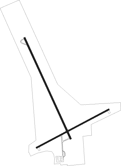
Runway info
Runway 15 / 33  | ||
| length | 1523m (4997ft) | |
| bearing | 151° / 331° | |
| width | 23m (75ft) | |
| surface | asphalt | |
| Runway 5 / 23 | ||
| length | 1125m (3691ft) | |
| bearing | 74° / 254° | |
| width | 18m (60ft) | |
| surface | asphalt | |
Nearby beacons
| code | identifier | dist | bearing | frequency |
|---|---|---|---|---|
| GTF | GREAT FALLS VORTAC | 38.1 | 117° | 115.10 |
| CTB | CUT BANK VOR/DME | 44.7 | 347° | 113.35 |
Instrument approach procedures
| runway | airway (heading) | route (dist, bearing) |
|---|---|---|
| RW15 | CTB (167°) | CTB AMURE (32mi, 173°) 6600ft |
| RW15 | GTF (297°) | GTF AMURE (49mi, 304°) 6600ft AMURE (turn) 6600ft |
| RNAV | AMURE 6600ft BEDEW (7mi, 151°) 5600ft KCII (6mi, 151°) 3986ft (6286mi, 113°) 4143ft CALAD (6286mi, 293°) 6200ft CALAD (turn) | |
| RW33 | CHOTE (357°) | CHOTE 7000ft |
| RW33 | SHIMY (352°) | SHIMY CHOTE (12mi, 349°) 7000ft |
| RNAV | CHOTE 7000ft DOZRE (5mi, 13°) 5600ft EMUTE (2mi, 345°) 5000ft FAMOT (3mi, 345°) 4065ft (6286mi, 113°) 4347ft AMURE (6287mi, 293°) 6600ft AMURE (turn) |
Disclaimer
The information on this website is not for real aviation. Use this data with the X-Plane flight simulator only! Data taken with kind consent from X-Plane 12 source code and data files. Content is subject to change without notice.