Cresco - Ellen Church Field
Airport details
| Country | United States of America |
| State | Iowa |
| Region | K3 |
| Airspace | Minneapolis Ctr |
| Municipality | Howard County |
| Elevation | 1277ft (389m) |
| Timezone | GMT -6 |
| Coordinates | 43.36530, -92.13308 |
| Magnetic var | |
| Type | land |
| Available since | X-Plane v10.40 |
| ICAO code | KCJJ |
| IATA code | n/a |
| FAA code | n/a |
Communication
Nearby Points of Interest:
Howard County Courthouse
-Lidtke Mill
-Bohemian Savings Bank
-Wenzil Taylor Building
-Burr Oak House/Masters Hotel
-Burr Oak Savings Bank
-Daniel Dayton House
-Kinney Octagon Barn
-Horn House
-Chickasaw County Courthouse
-Steyer Bridge
-Koren Hall
-Luther College Farm
-Decorah Municipal Bathhouse and Swimming Pool
-Pietenpol Workshop and Garage
-Painter-Bernatz Mill
-Norris Miller House
-Broadway-Phelps Park Historic District
-Decorah Woolen Mill
-Decorah Commercial Historic District
-Steyer Opera House
-Decorah Ice Cave State Preserve
-Milwaukee and St. Paul Railway Combination Depot
-Cooley-Whitney House
-Lenora Methodist Episcopal Church
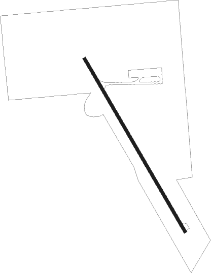
Runway info
| Runway 15 / 33 | ||
| length | 900m (2953ft) | |
| bearing | 146° / 326° | |
| width | 15m (50ft) | |
| surface | concrete | |
Nearby beacons
| code | identifier | dist | bearing | frequency |
|---|---|---|---|---|
| UKN | DME | 26.5 | 98° | 116.60 |
| IY | CHUKK (CHARLES CITY) NDB | 29.5 | 249° | 417 |
| RST | ROCHESTER VOR/DME | 32.1 | 312° | 112 |
| JAY | AUSTIN VOR/DME | 36.5 | 285° | 108.20 |
| ODI | NODINE VORTAC | 43.7 | 51° | 117.90 |
| LSE | CROSSE DME | 48.9 | 60° | 108.40 |
| ALO | WATERLOO VOR/DME | 49.9 | 198° | 112.20 |
| LS | MINDI (LA CROSSE) NDB | 53.9 | 54° | 272 |
| IIB | WAPSIE (INDEPENDENCE) NDB | 55.3 | 169° | 206 |
Disclaimer
The information on this website is not for real aviation. Use this data with the X-Plane flight simulator only! Data taken with kind consent from X-Plane 12 source code and data files. Content is subject to change without notice.