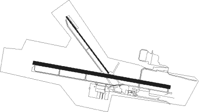
Port Angeles - William R Fairchild
Airport details
| Country | United States of America |
| State | Washington |
| Region | K1 |
| Airspace | Seattle Ctr |
| Municipality | Port Angeles |
| Elevation | 291ft (89m) |
| Timezone | GMT -8 |
| Coordinates | 48.12019, -123.49969 |
| Magnetic var | |
| Type | land |
| Available since | X-Plane v10.40 |
| ICAO code | KCLM |
| IATA code | CLM |
| FAA code | CLM |
Communication
| William R Fairchild ASOS | 135.175 |
| William R Fairchild CTAF/UNICOM | 122.975 |
| William R Fairchild WHIDBEY Approach/Departure | 118.200 |
Approach frequencies
| ILS-cat-I | RW08 | 108.9 | 18.00mi |
| 3° GS | RW08 | 108.9 | 18.00mi |
Nearby beacons
| code | identifier | dist | bearing | frequency |
|---|---|---|---|---|
| NOW | EDIZ HOOK (PORT ANGELES) NDB | 4 | 78° | 338 |
| CL | ELWHA (PORT ANGELES) NDB | 7 | 280° | 515 |
| FHR | FRIDAY HARBOR NDB | 30.2 | 51° | 284 |
| YJ | VICTORIA NDB | 31.7 | 11° | 200 |
| CVV | PENN COVE VOR/DME | 31.9 | 81° | 117.20 |
| MB | MILL BAY (VICTORIA) NDB | 33.1 | 356° | 293 |
| NUW | WHIDBEY ISLAND (OAK HARBO TACAN | 36.3 | 74° | 113.80 |
| YYJ | VICTORIA VOR/DME | 36.4 | 1° | 113.70 |
| AP | ACTIVE PASS NDB | 46 | 16° | 378 |
| YVR | VANCOUVER VOR/DME | 59.1 | 20° | 115.90 |
| WC | WHITE ROCK NDB | 60.8 | 40° | 332 |
| HUH | WHATCOM VORTAC | 61.6 | 48° | 113 |
Departure and arrival routes
| Transition altitude | 18000ft |
| Transition level | 18000ft |
| SID end points | distance | outbound heading | |
|---|---|---|---|
| RW08 | |||
| WATTR7 | 22mi | 88° | |
| RW13 | |||
| WATTR7 | 22mi | 88° | |
| RW26 | |||
| WATTR7 | 22mi | 88° | |
| RW31 | |||
| WATTR7 | 22mi | 88° | |
Instrument approach procedures
| runway | airway (heading) | route (dist, bearing) |
|---|---|---|
| RW08 | JIGEB (257°) | JIGEB YUCSU (35mi, 267°) 4700ft YUCSU (turn) 4700ft |
| RW08 | WATTR (268°) | WATTR YUCSU (39mi, 273°) 4700ft YUCSU (turn) 4700ft |
| RNAV | YUCSU 4700ft OCUVI (6mi, 100°) 3500ft LIGIY (4mi, 100°) 2200ft KCLM (6mi, 99°) 338ft (6704mi, 111°) 1000ft WATTR (6683mi, 291°) 5400ft WATTR (turn) 5400ft | |
| RW26 | JAWBN (278°) | JAWBN COBUX (12mi, 280°) 3700ft |
| RW26 | WATTR (268°) | WATTR COBUX (8mi, 253°) 3700ft |
| RNAV | COBUX 3700ft FAMUV (7mi, 272°) 3000ft SEBTY (4mi, 280°) 1620ft KCLM (4mi, 281°) 331ft (6704mi, 111°) 691ft MIDWI (6707mi, 291°) YUCSU (10mi, 271°) 4000ft YUCSU (turn) |
Disclaimer
The information on this website is not for real aviation. Use this data with the X-Plane flight simulator only! Data taken with kind consent from X-Plane 12 source code and data files. Content is subject to change without notice.

