Champaign/urbana - Univ Of Illinois Willard
Airport details
| Country | United States of America |
| State | Illinois |
| Region | K5 |
| Airspace | Chicago Ctr |
| Municipality | Champaign County |
| Elevation | 754ft (230m) |
| Timezone | GMT -6 |
| Coordinates | 40.03883, -88.27781 |
| Magnetic var | |
| Type | land |
| Available since | X-Plane v10.40 |
| ICAO code | KCMI |
| IATA code | CMI |
| FAA code | CMI |
Communication
| Univ of Illinois Willard ATIS | 124.850 |
| Univ of Illinois Willard CTAF | 120.400 |
| Univ of Illinois Willard UNICOM | 122.950 |
| Univ of Illinois Willard Clearance DEL | 128.750 |
| Univ of Illinois Willard Ground Control | 121.800 |
| Univ of Illinois Willard CHAMPAIGN Tower | 120.400 |
| Univ of Illinois Willard CHAMPAIGN Approach/Departure | 121.350 |
| Univ of Illinois Willard CHAMPAIGN Approach/Departure | 132.850 |
Approach frequencies
| ILS-cat-I | RW32R | 109.1 | 18.00mi |
| 3° GS | RW32R | 109.1 | 18.00mi |
Nearby Points of Interest:
University of Illinois Experimental Dairy Farm Historic District
-University of Illinois round barns
-Alpha Rho Chi Fraternity House
-Kappa Delta Rho Fraternity House
-Delta Upsilon Fraternity House
-Phi Delta Theta Fraternity House
-Kappa Sigma Fraternity House
-Sigma Alpha Epsilon Fraternity House
-Main Library
-Francis and Abbie Solon House
-Beta Theta Pi Fraternity House
-Astronomical Observatory (University of Illinois Urbana-Champaign)
-Alpha Phi Fraternity House-Beta Alpha Chapter
-Smith Memorial Hall
-Alpha Delta Phi Fraternity House
-Delta Kappa Epsilon Fraternity House
-Louise Freer Hall
-The Georgian
-Wee Haven
-Alpha Delta Pi Sorority House
-Busey-Evans Residence Halls
-Channing-Murray Foundation
-Gamma Phi Beta Sorority House
-George and Elsie Mattis House
-Frederick Squires House
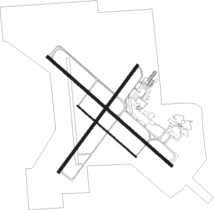
Runway info
Runway 14L / 32R  | ||
| length | 2472m (8110ft) | |
| bearing | 128° / 308° | |
| width | 46m (150ft) | |
| surface | concrete | |
| blast zone | 61m (200ft) / 61m (200ft) | |
| Runway 4 / 22 | ||
| length | 1981m (6499ft) | |
| bearing | 49° / 229° | |
| width | 46m (150ft) | |
| surface | concrete | |
| Runway 14R / 32L | ||
| length | 1165m (3822ft) | |
| bearing | 128° / 308° | |
| width | 23m (75ft) | |
| surface | asphalt | |
Nearby beacons
| code | identifier | dist | bearing | frequency |
|---|---|---|---|---|
| CMI | CHAMPAIGN VORTAC | 0.2 | 158° | 110 |
| CM | VEALS (CHAMPAIGN/URBANA) NDB | 6.1 | 127° | 407 |
| AXC | ADDERS VORTAC | 32.2 | 242° | 117.20 |
| RBS | ROBERTS VOR/DME | 33 | 12° | 116.80 |
| MTO | DME | 33.6 | 181° | 109.40 |
| DE | ELWIN (DECATUR) NDB | 34.5 | 250° | 275 |
| DNV | DANVILLE VORTAC | 36.4 | 71° | 111 |
| DN | JULIP (DANVILLE) NDB | 37.4 | 71° | 332 |
| BMI | BLOOMINGTON VOR/DME | 40 | 304° | 108.20 |
| LH | EGROW (BLOOMINGTON-NORMAL) NDB | 41.5 | 311° | 334 |
| SYZ | SHELBYVILLE NDB | 46 | 222° | 365 |
| PNT | PONTIAC VOR/DME | 51.3 | 330° | 109.60 |
| HU | YINNO (TERRE HAUTE) NDB | 56.4 | 126° | 245 |
| IK | LUKOW (KANKAKEE) NDB | 61.2 | 21° | 272 |
| VLA | VANDALIA VOR/DME | 69.9 | 223° | 114.30 |
Instrument approach procedures
| runway | airway (heading) | route (dist, bearing) |
|---|---|---|
| RW04 | ARCOL (1°) | ARCOL BOSTN (16mi, 328°) 2300ft |
| RW04 | AXC (62°) | AXC BOSTN (22mi, 69°) 2300ft |
| RW04 | CMI (338°) | CMI BOSTN (11mi, 230°) 2300ft BOSTN (turn) 2300ft |
| RNAV | BOSTN 2300ft AFTOR (6mi, 48°) 2300ft KIOWA (3mi, 49°) 1280ft KCMI (2mi, 48°) 792ft (5326mi, 114°) 1001ft MUGTE (5319mi, 295°) 2800ft MUGTE (turn) | |
| RW14L | BLLUE (107°) | BLLUE RRRED (6mi, 48°) 2800ft |
| RW14L | RBS (192°) | RBS ORANJ (23mi, 214°) 2800ft RRRED (5mi, 233°) 2800ft |
| RW14L | RRRED (128°) | RRRED 2800ft |
| RNAV | RRRED 2800ft GRANJ (6mi, 128°) 2700ft WORNO (4mi, 128°) 1380ft KCMI (3mi, 130°) 803ft (5326mi, 114°) 955ft ODEBE (5317mi, 294°) 2600ft ODEBE (turn) | |
| RW22 | DNV (251°) | DNV MUGTE (26mi, 259°) 2800ft |
| RW22 | MUGTE (229°) | MUGTE 2800ft |
| RW22 | RBS (192°) | RBS MUGTE (24mi, 173°) 2800ft |
| RNAV | MUGTE 2800ft ZUPKE (6mi, 229°) 2400ft JESDI (3mi, 229°) 1460ft KCMI (3mi, 229°) 789ft (5326mi, 114°) 1000ft BOSTN (5333mi, 294°) 2300ft BOSTN (turn) | |
| RW32R | CMI (338°) | CMI ODEBE (12mi, 127°) 2600ft ODEBE (turn) 2600ft |
| RW32R | NEWMY (298°) | NEWMY ODEBE (7mi, 282°) 2600ft |
| RW32R | OCTOE (251°) | OCTOE SUGKO (11mi, 170°) 2600ft ODEBE (5mi, 233°) 2600ft |
| RW32R | TUSCO (1°) | TUSCO TULKE (6mi, 72°) 2600ft ODEBE (5mi, 53°) 2600ft |
| RNAV | ODEBE 2600ft ZAGMO (6mi, 308°) 2600ft NUVIY (3mi, 308°) 1560ft KCMI (3mi, 306°) 801ft (5326mi, 114°) 1000ft HIPUB (5330mi, 294°) LODGE (7mi, 280°) 2800ft LODGE (turn) |
Disclaimer
The information on this website is not for real aviation. Use this data with the X-Plane flight simulator only! Data taken with kind consent from X-Plane 12 source code and data files. Content is subject to change without notice.