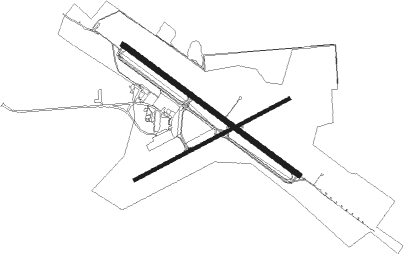
Hancock - Houghton Co Mem
Airport details
| Country | United States of America |
| State | Michigan |
| Region | K5 |
| Airspace | Minneapolis Ctr |
| Municipality | Osceola Township |
| Elevation | 1095ft (334m) |
| Timezone | GMT -5 |
| Coordinates | 47.16842, -88.48906 |
| Magnetic var | |
| Type | land |
| Available since | X-Plane v10.40 |
| ICAO code | KCMX |
| IATA code | CMX |
| FAA code | CMX |
Communication
| Houghton Co Mem ASOS | 125.675 |
| Houghton Co Mem CTAF/UNICOM | 122.700 |
| Houghton Co Mem unnamed entity | 128.800 |
Approach frequencies
| ILS-cat-I | RW31 | 110.3 | 18.00mi |
| 3° GS | RW31 | 110.3 | 18.00mi |
Nearby Points of Interest:
Quincy Mining Company Stamp Mills Historic District
-Keweenaw National Historical Park
-Calumet Historic District
-First Congregational Church
-Joseph Bosch Building
-Lake Linden Historic District
-Lake Linden Village Hall and Fire Station
-College Club House and Gymnasium
-Ransom B. Shelden House
-Quincy Mine No. 2 Shaft Hoist House
-John J. Michels House
-East Hancock
-Shelden-Dee Block
-Shelden Avenue Historic District
-Houghton County Courthouse
-Scott Hotel
-J. Vivian, Jr. and Company Building
-Thomas H. Hoatson House
-Quincy Street Historic District
-Hancock Town Hall and Fire Hall
-Old Hancock Central High School
-Calumet and Hecla Industrial District
-Old Main, Suomi College
-Lieblein House
-Calumet Downtown Historic District

Nearby beacons
| code | identifier | dist | bearing | frequency |
|---|---|---|---|---|
| CMX | HOUGHTON (HANCOCK) VOR/DME | 0.1 | 63° | 112.80 |
| RXW | WATERSMEET NDB | 62 | 222° | 407 |
Instrument approach procedures
| runway | airway (heading) | route (dist, bearing) |
|---|---|---|
| RW07 | CMX (243°) | CMX FAXET (12mi, 253°) 3700ft FAXET (turn) 3700ft |
| RNAV | FAXET 3700ft CEDAG (6mi, 74°) 2900ft WUMRO (3mi, 74°) 2020ft KCMX (3mi, 73°) 1114ft (5343mi, 118°) 1431ft ZORIV (5333mi, 298°) 3700ft ZORIV (turn) | |
| RW13 | CMX (243°) | CMX BAPYA (12mi, 300°) 3700ft BAPYA (turn) 3700ft |
| RW13 | FEMOK (140°) | FEMOK BAPYA (10mi, 172°) 3700ft |
| RW13 | PAVGE (69°) | PAVGE JOVSI (9mi, 348°) 3700ft BAPYA (8mi, 52°) 3700ft |
| RNAV | BAPYA 3700ft FEGOD (6mi, 120°) 2900ft KCMX (6mi, 121°) 1141ft (5343mi, 118°) 2400ft BAPYA (5353mi, 298°) 3700ft BAPYA (turn) | |
| RW25 | CMX (243°) | CMX ZORIV (11mi, 74°) 3700ft ZORIV (turn) 3700ft |
| RNAV | ZORIV 3700ft HAMIP (6mi, 254°) 2800ft KCMX (6mi, 254°) 1120ft (5343mi, 118°) 1440ft FAXET (5354mi, 298°) 3700ft FAXET (turn) | |
| RW31 | CIBPA (343°) | CIBPA MUMBY (9mi, 69°) 3000ft |
| RW31 | CMX (243°) | CMX MUMBY (14mi, 121°) 3000ft MUMBY (turn) 3000ft |
| RW31 | PEVXI (306°) | PEVXI MUMBY (3mi, 333°) 3000ft |
| RNAV | MUMBY 3000ft COPKA (9mi, 301°) 2500ft KCMX (5mi, 300°) 1108ft (5343mi, 118°) 1320ft BAPYA (5353mi, 298°) 3700ft BAPYA (turn) |
Disclaimer
The information on this website is not for real aviation. Use this data with the X-Plane flight simulator only! Data taken with kind consent from X-Plane 12 source code and data files. Content is subject to change without notice.