Sparta - Sparta Fort Mc Coy
Airport details
| Country | United States of America |
| State | Wisconsin |
| Region | K5 |
| Airspace | Minneapolis Ctr |
| Municipality | Town of Angelo |
| Elevation | 835ft (255m) |
| Timezone | GMT -6 |
| Coordinates | 43.95837, -90.73790 |
| Magnetic var | |
| Type | land |
| Available since | X-Plane v10.40 |
| ICAO code | KCMY |
| IATA code | CMY |
| FAA code | CMY |
Communication
| Sparta Fort Mc Coy AWOS 3 | 118.375 |
| Sparta Fort Mc Coy CTAF | 124.600 |
| Sparta Fort Mc Coy GRND | 123.100 |
| Sparta Fort Mc Coy Tower | 124.600 |
| Sparta Fort Mc Coy VOLK Approach/Departure | 135.250 |
Nearby Points of Interest:
William G. and Anne Williams House
-St. John's Episcopal Church
-Sparta Free Library
-Sparta Masonic Temple
-Monroe County Courthouse
-Tomah Public Library
-Albert and Theresa Marx House
-Hamlin Garland House
-Palmer Brothers Octagons
-Black River Falls Public Library
-Frank Eugene Nichols House
-23rd and 24th Streets Historic District
-Our Lady of Sorrows Chapel
-Wittich Hall
-LaCrosse State Teachers College Training School Building
-Gideon C. Hixon House
-St. Rose of Viterbo Convent
-La Crosse Commercial Historic District
-Mons Anderson House
-La Crosse Armory
-Northern Wisconsin Co-op Tobacco Pool Warehouse
-Vernon County Courthouse
-Masonic Temple Building
-John F. Cance House
-Downtown Historic District
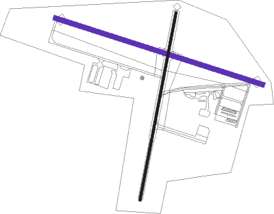
Runway info
| Runway 11 / 29 | ||
| length | 1429m (4688ft) | |
| bearing | 106° / 286° | |
| width | 30m (100ft) | |
| surface | asphalt | |
| displ threshold | 0m (0ft) / 131m (430ft) | |
Runway 1 / 19  | ||
| length | 1255m (4117ft) | |
| bearing | 21° / 201° | |
| width | 15m (50ft) | |
| surface | asphalt | |
| displ threshold | 415m (1362ft) / 114m (374ft) | |
Nearby beacons
| code | identifier | dist | bearing | frequency |
|---|---|---|---|---|
| CMY | MC COY NDB | 4.3 | 102° | 412 |
| VOK | VOLK (CAMP DOUGLAS) TACAN | 20.7 | 92° | 110.40 |
| LS | MINDI (LA CROSSE) NDB | 22.7 | 275° | 272 |
| LSE | CROSSE DME | 22.9 | 261° | 108.40 |
| DAF | NECEDAH NDB | 28.6 | 83° | 233 |
| ODI | NODINE VORTAC | 31.6 | 266° | 117.90 |
| LNR | ROCK DME | 47.7 | 138° | 116.05 |
| DLL | DELLS (BARABOO) VORTAC | 48.8 | 113° | 117 |
| UKN | DME | 53.5 | 230° | 116.60 |
| EAU | EAU CLAIRE VORTAC | 64.7 | 322° | 113.65 |
Instrument approach procedures
| runway | airway (heading) | route (dist, bearing) |
|---|---|---|
| RW11 | BOOTY (54°) | BOOTY JADKU (10mi, 292°) 3000ft ESOKY (11mi, 29°) 3000ft |
| RW11 | ODI (86°) | ODI ESOKY (20mi, 71°) 3000ft |
| RNAV | ESOKY 3000ft EJIVY (8mi, 106°) 2900ft CEKUS (3mi, 106°) 1960ft KCMY (4mi, 107°) 862ft (5437mi, 116°) 1700ft FAPKO (5427mi, 296°) 4000ft FAPKO (turn) | |
| RW29 | FAPKO (316°) | FAPKO KOLGY (11mi, 1°) 3200ft |
| RNAV | KOLGY 3200ft HUVEG (4mi, 287°) 3000ft BEJAY (2mi, 286°) 2500ft FASGO (2mi, 286°) 1720ft KCMY (3mi, 285°) 871ft (5437mi, 116°) 1107ft ESOKY (5451mi, 296°) 4000ft ESOKY (turn) |
Disclaimer
The information on this website is not for real aviation. Use this data with the X-Plane flight simulator only! Data taken with kind consent from X-Plane 12 source code and data files. Content is subject to change without notice.