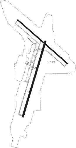
Columbia - Columbia Regl
Airport details
| Country | United States of America |
| State | Missouri |
| Region | K3 |
| Airspace | Kansas City Ctr |
| Municipality | Boone County |
| Elevation | 889ft (271m) |
| Timezone | GMT -6 |
| Coordinates | 38.81810, -92.21963 |
| Magnetic var | |
| Type | land |
| Available since | X-Plane v10.40 |
| ICAO code | KCOU |
| IATA code | COU |
| FAA code | COU |
Communication
| Columbia Regl ATIS | 128.450 |
| Columbia Regl UNICOM | 122.950 |
| Columbia Regl Ground Control | 121.600 |
| Columbia Regl Tower | 119.300 |
| Columbia Regl MIZZU Approach/Departure | 124.375 |
Approach frequencies
| ILS-cat-I | RW02 | 110.7 | 18.00mi |
| 2.8° GS | RW02 | 110.7 | 18.00mi |
Nearby Points of Interest:
Maplewood
-Bond's Chapel Methodist Episcopal Church
-Samuel E. Hackman Building
-David Gordon House and Collins Log Cabin
-East Campus Neighborhood
-Frederick Apartments
-Sanford F. Conley House
-Senior Hall
-Missouri State Teachers Association Building
-Coca-Cola Bottling Company Building
-Virginia Building
-Stephens College South Campus Historic District
-Ballenger Building
-Kress Building
-Sigma Alpha Epsilon Fraternity House
-Eighth and Broadway Historic District
-Downtown Columbia
-Central Dairy Building
-Missouri, Kansas, and Texas Railroad Depot
-McCain Furniture Store
-Columbia National Guard Armory
-John W. Boone House
-Wright Brothers Mule Barn
-Samuel H. and Isabel Smith Elkins House
-Second Christian Church
Nearby beacons
| code | identifier | dist | bearing | frequency |
|---|---|---|---|---|
| COU | COLUMBIA VOR/DME | 0.4 | 169° | 110.20 |
| JE | ALGOA (JEFFERSON CITY) NDB | 17.6 | 151° | 397 |
| HLV | HALLSVILLE VORTAC | 18.2 | 17° | 114.20 |
| VIH | VICHY (ROLLA/VICHY) VOR/DME | 46.6 | 142° | 117.70 |
| SHY | SUNSHINE (KAISER) VOR/DME | 50 | 206° | 108.40 |
| MCM | DME | 51.6 | 343° | 112.90 |
Instrument approach procedures
| runway | airway (heading) | route (dist, bearing) |
|---|---|---|
| RW02 | LIDPE (56°) | LIDPE ULUFA (6mi, 107°) 3100ft |
| RW02 | RAGVE (351°) | RAGVE ULUFA (6mi, 287°) 3100ft |
| RW02 | ULUFA (26°) | ULUFA 3100ft |
| RNAV | ULUFA 3100ft FECFE (7mi, 27°) 2500ft SHAME (2mi, 27°) 1820ft KCOU (4mi, 25°) 927ft (5509mi, 113°) 1089ft AGVOY (5504mi, 293°) 3100ft AGVOY (turn) | |
| RW13 | NAHWI (161°) | NAHWI NAYLU (6mi, 232°) 3100ft |
| RW13 | NAYLU (130°) | NAYLU 3100ft |
| RW13 | OPNEJ (104°) | OPNEJ NAYLU (6mi, 52°) 3100ft |
| RNAV | NAYLU 3100ft RIYVO (6mi, 128°) 2500ft ROPSE (3mi, 128°) 1680ft KCOU (3mi, 134°) 933ft (5509mi, 113°) 2000ft NAYLU (5517mi, 293°) 3100ft NAYLU (turn) | |
| RW20 | AGVOY (207°) | AGVOY 3100ft |
| RW20 | UZOTY (245°) | UZOTY AGVOY (9mi, 287°) 3100ft |
| RW20 | YEGSA (160°) | YEGSA AGVOY (9mi, 107°) 3100ft |
| RNAV | AGVOY 3100ft FEZFY (6mi, 207°) 2500ft PUNTY (2mi, 207°) 1800ft KCOU (3mi, 209°) 931ft (5509mi, 113°) 1139ft ULUFA (5514mi, 293°) 3100ft ULUFA (turn) | |
| RW31 | AJQUR (307°) | AJQUR 3100ft |
| RW31 | JOTUD (282°) | JOTUD AJQUR (6mi, 232°) 3100ft |
| RW31 | WEGSI (339°) | WEGSI AJQUR (6mi, 52°) 3100ft |
| RNAV | AJQUR 3100ft IHJAK (6mi, 309°) 2500ft JUBAX (2mi, 309°) 1760ft KCOU (3mi, 304°) 931ft (5509mi, 113°) 1138ft NAYLU (5517mi, 293°) 3100ft NAYLU (turn) |
Disclaimer
The information on this website is not for real aviation. Use this data with the X-Plane flight simulator only! Data taken with kind consent from X-Plane 12 source code and data files. Content is subject to change without notice.

